After a very slow storm season in 2020 with only 17 tornadoes (NCEI Storm Database), the 2021 storm season is following suit. Only two tornadoes have been reported thus far and none occurred in April. There was one land spout in Cheyenne County and one EF-0 in Johnson County, both in March. A quiet April is notable since the three core severe weather months in Kansas are April, May, and June. However, this wasn’t the first time that no tornadoes have been reported for the April. In fact, this has happened 14 times previously (Figure 1). Note that before 1990, record keeping was less reliable. However, recent years such as 2020, 2018, 2004 and 1996 recorded zero tornadoes for April. While this doesn’t occur often, it definitely is possible.
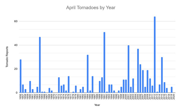
Figure 1. April reported tornadoes since 1956 (Data from NCEI Storm Database).
What does a quiet April mean for the rest of the severe weather season?
Kansas tornado season peaks in May, averaging 27 tornadoes across the state. That is just shy of half the yearly average of 67 over the last 65 years. These small scale events rely on daily to weekly weather patterns and with only small implications from preceding weather in the months before. While the prior months still influence the tornado season, it isn’t an accurate indicator of what will come. Of the 14 years of which there were no April tornadoes, the following Mays totals ranged from 66 in 2004 to 1 in 1967. The average May tornadoes following a quiet April fall about five tornadoes shy of the typical May average (23, Table 1). However, normally the overall tornado count for the entire year is much less than average by over 20 tornadoes. Very active Aprils (11+ tornadoes) yield the same average tornado count as below normal but closer to average Aprils (1-10). However, the final tornado counts for the year are over 20 more than the 65-year average.
Table 1. Average tornadoes for April, April count, and the May/yearly totals for those respective years (Data from NCEI Storm Database).
|
|
April |
May |
Year |
|
|
65-Yr Average |
10 |
27 |
67 |
|
|
April Tornado Count |
Zero |
0 |
23 |
44 |
|
One to Ten |
5 |
28 |
61 |
|
|
Eleven Plus |
26 |
28 |
93 |
|
Lastly, one of the big factors that meteorologists mention going into a new season is the overall global weather influencers - the biggest being the El Niño-Southern Oscillation. This includes the eastern Pacific Ocean temperatures which often have warm/dry and wet/cool impacts for the United States in the Fall/Winter/Spring. This winter consisted of a La Niña (-0.5°C, cooler-than-normal waters at the surface). While many other “destructive” or interfering patterns existed which reduced La Niña impacts across the Central Plains this winter, it is still a significant factor considered going into spring. Recent research indicated that La Niña events yielded an increase in both tornadoes and hail occurrences in the southeast part of the state (https://www.climate.gov/news-features/blogs/enso/enso-and-tornadoes).
Examining the NCEI Storm Database, with La Niña conditions in place from December through February, April tornadoes are usually just slightly above normal (13, Table 2) with May tornadoes ever so slightly below normal. Interestingly enough, La Niña typically sees more tornadoes than either Neutral or El Nino conditions in April. May however, typically favors neutral conditions for above normal tornado reports. All conditions still yield near average annual tornado counts. That is most likely the result of ENSO conditions usually changing (slowly) through the year as summers typically favor Neutral conditions.
Table 2. ENSO conditions and April, May, and yearly tornado averages for Kansas (Data from NCEI Storm Database and Climate Prediction Center).
|
Kansas Tornadoes and ENSO (DJF) |
|||
|
|
April |
May |
Year |
|
Average |
10 |
27 |
67 |
|
La Nina (-0.5) |
13 |
24 |
67 |
|
Neutral |
7 |
29 |
66 |
|
El Nino (+0.5) |
8 |
27 |
67 |
In conclusion, evidence doesn’t show that quiet Aprils result in quiet Mays. However, they do often imply overall below-normal tornado numbers for the year. Factors that influence tornado occurrences usually result from dynamic storm systems that bring outbreak-type events and/or a long duration persistent severe weather events. Thus far in 2021, we haven’t seen that. This spring, drought conditions have expanded and abnormally dry now stretches across most of southern Kansas. Another concern resides in the southwest with persistent extreme drought. Strong storm systems move that dry air to the northeast over the Central Plains (Figure 2). This results in warm/dry air above the surface in the mid-levels of the atmosphere. It can contribute to increased instability but it also aids in “capping” or subsidence just above the surface. Stronger caps usually prevent storm development. This could help suppress storm activity but can also aid in severe weather. Should a storm develop, they are often isolated in nature and result in more severe weather over a localized area - possibly increasing tornado concerns. Lastly, this type of pattern requires an active jet-stream with strong systems in the western US. So far this year though, high pressure has been persistent in the west and not allowed development of these dynamic systems.
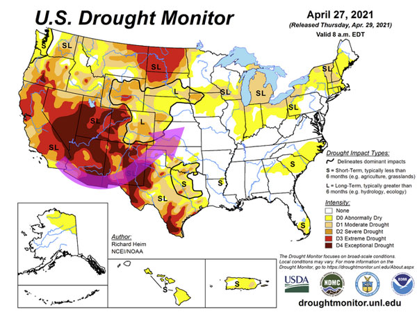
Figure 2. Current drought monitor and favorable atmospheric flow for severe weather in the Central Plains (Drought Monitor).
All we can hope for in May is a more favorable pattern for moisture without tornadoes and severe weather. That combination is hard to get in spring but one can always hope!
Chip Redmond, Kansas Mesonet Manager
christopherredmond@ksu.edu
Madison Flory, K-State student
Mary Knapp, Assistant State Climatologist
mknapp@ksu.edu
Tags: weather severe weather tornado