Despite two cold weeks in January, winter 2023-2024 has been warm. Precipitation was much above normal until February. Now, things are drying out and greening up, and the landscape is in need of precipitation. This article will look to the future and provide some ideas of what to expect for spring and early summer 2024.
The Past
Since meteorological winter began in December, many locations in the state are running in the top five warmest and wettest winters on record. This is despite a very cold middle of January and a very dry last 20 days across the region. During typical El Niño winters, Kansas usually finds itself on the battleground of typical above/below normal precipitation and temperature with anomalies near normal. However, we usually see an increased probability of warm extremes (Figure 1, left) and wet extremes (Figure 1, right). This has been well aligned with conditions across the state in the winter.
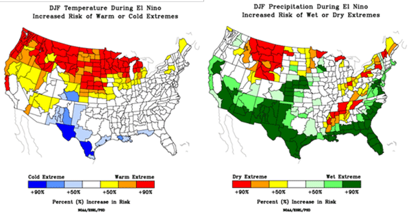
Figure 1. Probability of extremes during El Niño winters (December, January and February) for temperatures (left) and precipitation (right). Source: https://psl.noaa.gov/enso/climaterisks/.
This is great news with the drought significantly improved this winter (Figure 2). In fact, we completely removed all D4 (exceptional) and D3 (extreme) drought across the state. This has resupplied soil moisture compared to November (Figure 3) and helped improve the wheat to 57% rated good or excellent (compared to only 19% this time in 2023), according to USDA NASS.
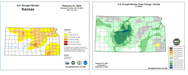
Figure 2. The United States Drought Monitor as of February 20, 2024 (left) and the change in the Drought Monitor over the last 12 weeks.
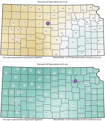
Figure 3. Soil moisture percent of saturation at the 5 cm (2 inches) depth in November (left) and February (right) on the Kansas Mesonet. Source: https://mesonet.k-state.edu/agriculture/soilmoist/
The Current
While El Niño has contributed to our weather pattern this winter, it wasn’t the only influencer. The Pacific Decadal Oscillation (PDO) in the North Pacific, the Polar Vortex, and the Madden-Julian Oscillation (MJO) have all played roles in this warm and wet winter. As we move further into early spring, the Polar Vortex climatologically weakens and is usually a shrinking factor. So, we will focus on the North Pacific (PDO) and the equatorial East Pacific ENSO (where El Niño resides) for this outlook.
With the persistent El Nino enhanced jet stream, we continue to have an active weather pattern across North America as in a classic Niño winter pattern (Figure 4). Additionally, we have a negative PDO, basically warm water in the middle North Pacific and cold water off the Alaska/Canadian Pacific coast. This decadal oscillation often lasts around ten years. We are several years into the current cycle and it has weakened some. However, this helps drive more of a dry, northwest flow into the United States and usually contradicts El Niño. This has resulted in a split flow (two active jet streams) across the US (Figure 4, right). This does several things. First, it allows for a continued active pattern with storm systems and frequent cold fronts. It doesn’t allow for a true “arctic” air mass to build but rather allows for short-duration frequent “cooler” air masses to push south into the US. This, in turn, typically steers Gulf of Mexico moisture, our main source of precipitation, off to the east and away from Kansas. This is the main reason we have been dry across the Central Plains for the last 25+ days. Until the pattern breaks with a more “phased” or unified jet stream, we won’t get a stout weather change. This means more warmth, wind, and fire weather, and less precipitation and cold. While the current outlook for March is for wetter than normal precipitation and equal chances of at/above/below normal temperatures from CPC, this may be a challenge to verify with the current expected pattern into mid-March.
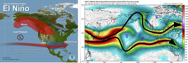
Figure 4. Typical winter El Nino pattern from the Climate Prediction Center (left) and the current upper-level wind/jet streams across the Pacific Ocean (right) from TropicalTidbits.com and arrows annotated by the author.
The Future
As we move into mid-spring, there are many concerns despite recent positives with soil moisture and drought. First is winter wheat. While it is rated well, the early green-up will lead to extreme vulnerability to freeze and frost in late spring (see the companion article in the eUpdate about the risk of warm winter temperatures on wheat). Even with a warmer-than-normal spring, one or two brief cold air intrusions could be detrimental. Secondly, precipitation will need to keep up with actively growing vegetation to ensure that there is topsoil moisture for crop planting.
First, with the persistence of the PDO and the upwelling of colder water in the Pacific, it is almost guaranteed that El Niño will diminish. In fact, we are already seeing a downward trend in the temperature anomalies in the East Pacific. This transition isn’t uncommon for the spring but does bring with it some challenges. We still face the “spring barrier” that usually results in some forecast uncertainty for the summer. Some models even suggest that waters cool to the point of potential La Niña emergence mid-summer. There have been ten years in which we transitioned from El Niño in December through February to La Niña in the June - August timeframe. This transition is favorable for severe weather and regional tornado outbreaks (Figure 5), according to a 2016 NOAA study (Lee et al. 2016).
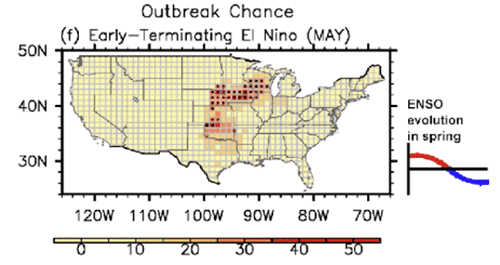
Figure 5. Regional tornado outbreak probability during a weakening El Niño centered on a transition in May (Lee et al. 2016).
When we consider an increase in severe weather, we must also consider the increased probability of moisture as a result. When an active El Nino jet stream seasonally shifts north, this opens the door for increased storm systems that also provide precipitation. In the ten years of the previous El Niño to La Niña transition, the months of March-May have yielded a statewide average precipitation departure from normal of +0.52”. However, that doesn’t mean the precipitation was spread equally.
Spring-driven storm systems usually have a dry side that is oriented along the High Plains with an easterly pushing dryline. These dry areas of the storm often setup in the same area that had above-normal precipitation last growing season. This resulted in a substantial amount of grass growth, which then increased wildfire concern (see companion article on wildfires). We have already seen large fires in Texas, Oklahoma, and Nebraska. The probability of an increase in wildfires in western Kansas is higher than normal during these events. With these considerations, the CPC is calling for above-normal moisture for March-May in eastern portions of the state where storms are most favored (Figure 6). Further west, with those dryline intrusions, there is less precipitation certainty with equal chances of at/above/below normal moisture being favored.
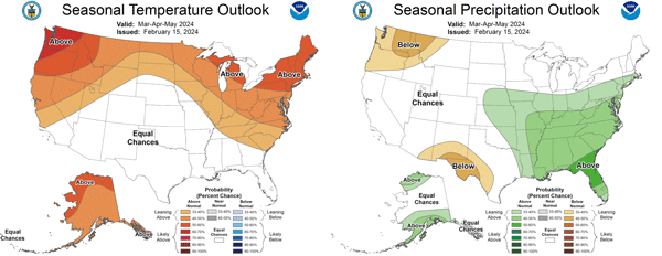
Figure 6. CPC probability outlooks for the three-month average of March, April, and May 2024.
Unfortunately, the average precipitation becomes less than normal for the summer in the ten El Niño spring transitions to La Niña. While there were wetter years and some areas of above-normal precipitation, the June - August average for those summers is -0.17” below normal. Additionally, the probability of precipitation dry extremes during a La Niña period in the summer is higher for portions of Kansas, the Rockies, and the northern Plains (Figure 7, left). Using an average of all the climate models that can forecast precipitation anomalies, a drier-than-normal signal is prominent for the June - August timeframe (Figure 7, right). Therefore, it seems likely that drier than normal would emerge this summer. Some models even have the switch occurring rapidly in the middle of spring. Our focus turns towards the southern High Plains where drought has already been re-established. This could be a source area for drier/warmer conditions to create a negative feedback cycle, potentially expanding northward into Kansas during the summer. Therefore, there is a higher likelihood of greater agricultural stress on warm-season crops. The CPC seems to agree about these trends with their June - August outlook (Figure 8). Above-normal temperatures are also favored. This would lead to an increased risk of flash drought and higher atmospheric moisture demands.
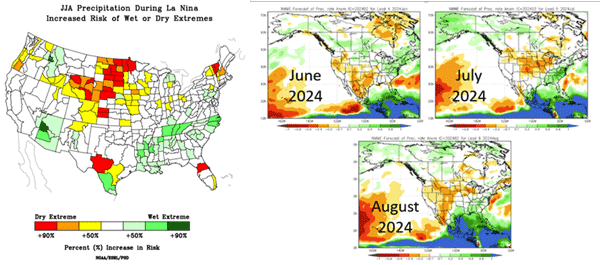
Figure 7. Probability of wet and dry extremes during La Niña summers (https://psl.noaa.gov/enso/climaterisks/) and the precipitation anomalies forecasted from an average of all climate models for June, July, and August 2024 as of February 2024 model runs (https://www.cpc.ncep.noaa.gov/products/NMME/).
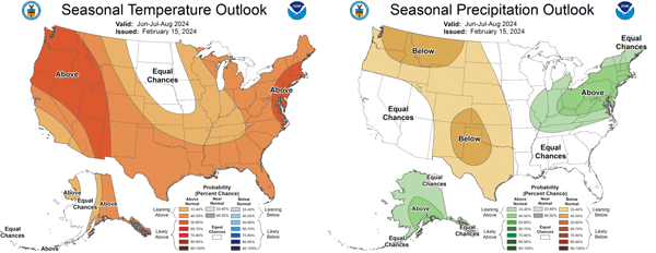
Figure 8. CPC probability outlooks for the three-month average of June, July, and August 2024.
The Bottom Line
As with any transition season (spring and fall) there are many unknowns of the expected weather. El Niño remains our most dominant seasonal driver, but as it weakens, the negative Pacific Decadal Oscillation and underlying potential emerging La Niña may take over late spring and early summer. This would likely result in a more active than normal spring with severe weather and potentially moisture, especially for eastern Kansas. Unfortunately, drought is already established in southern New Mexico and southwest Texas. This dryness is likely to expand northward with a drier and warmer than normal summer favored for Kansas.
Reference
Lee, S.-K., A. T. Wittenberg, D. B. Enfield, S. J. Weaver, C. Wang, and R. M. Atlas. US regional tornado outbreaks and their links to spring ENSO phases and North Atlantic SST variability. 2016. Environmental Research Letters. DOI:10.1088/1748-9326/11/4/044008
Chip Redmond, Kansas Mesonet Manager
christopherredmond@ksu.edu
Tags: weather spring climate spring outlook