This year has had a slow start to fire season across the state. This has been in part to dry conditions not aligning with environmental conditions. As a result, fire weather concerns have been marginal and there have been fewer than normal large fires across the state. Unfortunately, conditions are changing as several wind events are forecasted for the coming days combined with very dry air. Therefore, it’s important to understand the different types of fire weather products issued by the National Weather Service as they are issued in the coming days: Red Flag Warnings and Fire Weather Watches.
A Red Flag Warning is issued for critical fire danger and signifies that those weather conditions are occurring, or will occur shortly. These critical weather conditions consist of a combination of strong winds, low relative humidity, and warm temperatures – all of which make fire suppression very challenging. Thresholds for these warnings vary by your local associated NWS forecast office (see Table 1).
A Fire Weather Watch is issued in advance of critical fire danger. These Watches signify the forecasted possibility of critical fire weather occurring in the next 24-48 hours. Some offices issue these more than others. These Watches are meant to provide you advance notice so that you can take proper precautions and/or make better decisions based upon these forecasts.
Table 1. Red Flag thresholds by National Weather Service Forecast Office
|
Red Flag Warning Thresholds |
||
|
Forecast Office |
Relative Humidity |
Wind Speeds/Gusts |
|
Goodland |
15% |
Gusts 25 mph or greater |
|
Dodge City |
15% |
Gusts 25 mph or greater |
|
Hastings, NE |
20% |
Sustained winds 20mph/gusts 25 mph |
|
Wichita |
Extreme Grassland Fire Danger Index |
|
|
Topeka |
20% |
Sustained winds 20mph/gusts 25 mph |
|
Pleasant Hill, MO |
25% |
Gusts 25 mph or greater |
|
Springfield, MO |
25% |
Gusts 25 mph or greater |
Generally, these weather conditions create an atmosphere with explosive fire growth potential. Any spark has the potential to create a large fire that will resist typical suppression efforts. Use appropriate caution, such as avoiding outdoor burning, watching for hot exhaust systems over grass, and extra care with welding or anything that might create sparks.
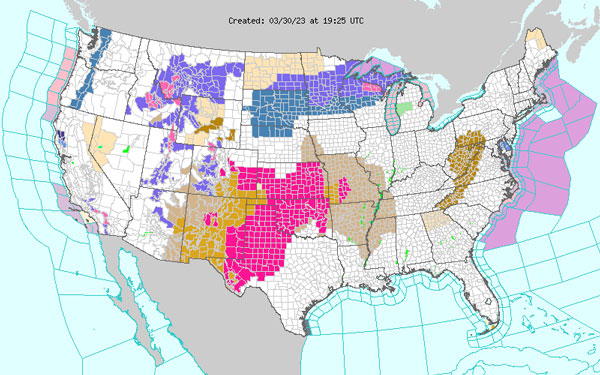
Note that these Warnings/Watches only occur when fuels (material that burns such as grass, leaves, cedars, etc.) are able to efficiently carry fire. During the winter, our grasses are dormant and dead. This provides ample fuel for the fire to easily carry. Therefore, these alerts most often occur between October and May (Figure 1), until the spring rains arrive to drive grass growth again. This doesn’t mean that the fire weather potential isn’t there for the remaining months. During periods of drought, grasses can become dormant and carry fire. These particular situations are more difficult to forecast in advance. Reports of fire carrying exceptionally well and being difficult to suppress are critical to the forecast process. If you feel these conditions are occurring, don’t hesitate to contact your local office and spread that information.

Figure 1. Red flag warnings (bright pink) on March 30, 2023. Source: National Weather Service
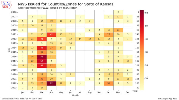
While 2023 Red Flag Warnings have numbered less than the last few years so far (Figure 2), it is important to note that our fire season stretches for several more months. With the increase in fire conducive conditions, these numbers will increase as well in the coming days. Similar to last year when fire season peaked in April, the recent cold spell in March has slowed down spring green up. This allows for vegetation across the state to be continually conducive to fire spread. It will remain this way until multiple significant moisture events occur and warmer temperatures remain consistent, allowing for cool season grasses to green.

Figure 2. Red Flag Warnings issued in Kansas by month since 2006. Image from the Iowa Environmental Mesonet.
Christopher "Chip" Redmond, Kansas Mesonet
Christopherredmond@ksu.edu