Meteorological summer came to an end on August 31. We are now entering the second week of meteorological fall, and so far, temperatures have been reminiscent of autumn. Below normal temperatures have been the rule as of late. September 8 was the 17th consecutive day of below-normal temperatures, based on the average daily temperature across the Kansas Mesonet. You may be surprised to learn that this is the longest such run since a 25-day run in February and March of 2019, about six and a half years ago! This string is partly responsible for pulling August’s average temperature down, which in turn pulled summer’s average temperature down as well. The official monthly average temperature for August was released by the National Centers for Environmental Information on September 9. The average of 75.9°F was 1.2° below normal and ranked as the 40th coldest August in 131 years of record keeping. Combined with June and July’s average temperatures, meteorological summer finished 0.1° below normal. The summer of 2024, by comparison, finished 0.9° above normal.
Are we completely done with the heat? We may not be quite through with 90-degree temperatures (more on that later), but the likelihood of temperatures that warm is decreasing daily. Average daily highs and lows have already begun their annual retreat from their summertime peaks. For example, Goodland’s hottest average daily high is 91°, which is the average high from July 9 through 25. As of today, September 11, the average high is down to 82° and, in less than three weeks, the average high on the last day of September will be just 74°. The descent into cooler readings is slow at first but increases more rapidly in autumn. Let’s take a closer look at the timeline for the annual arrival of cooler days and nights, and when during fall that average highs and lows reach various thresholds.
We are in the opening act of Mother Nature’s magic show, where summertime warmth vanishes into thin air. On September 1 (the first day of meteorological fall), average high temperatures across the state ranged from 84° in the northeast to 88° in the southwest and south central Kansas. Highs in the 90s are common in early September. By the end of September, average highs are in the mid and upper 70s statewide. During October, daily averages fall more rapidly; the rate of decrease is nearly half a degree per day. By Halloween, highs are normally in the low to mid 60s. By Thanksgiving, daytime highs average only in the low 50s. Table 1 lists the average dates each of Kansas’ nine climate divisions reaches thresholds starting at 85° and decreasing by five degrees down to 50°.
Table 1. Dates when divisional average daily high temperatures fall to the thresholds listed at the top and bottom of each column.
|
Division |
85 °F |
80 °F |
75 °F |
70 °F |
65 °F |
60 °F |
55 °F |
50 °F |
|
Northwest |
Sep 5 |
Sep 19 |
Sep 30 |
Oct 11 |
Oct 22 |
Nov 2 |
Nov 13 |
Nov 24 |
|
North Central |
Sep 4 |
Sep 19 |
Oct 1 |
Oct 12 |
Oct 23 |
Nov 2 |
Nov 13 |
Nov 23 |
|
Northeast |
Aug 29 |
Sep 15 |
Sep 29 |
Oct 11 |
Oct 22 |
Nov 2 |
Nov 12 |
Nov 23 |
|
West Central |
Sep 6 |
Sep 21 |
Oct 2 |
Oct 13 |
Oct 24 |
Nov 4 |
Nov 15 |
Nov 27 |
|
Central |
Sep 8 |
Sep 22 |
Oct 4 |
Oct 15 |
Oct 26 |
Nov 6 |
Nov 17 |
Nov 27 |
|
East Central |
Sep 1 |
Sep 16 |
Sep 30 |
Oct 12 |
Oct 24 |
Nov 4 |
Nov 15 |
Nov 26 |
|
Southwest |
Sep 13 |
Sep 26 |
Oct 8 |
Oct 19 |
Oct 30 |
Nov 10 |
Nov 21 |
Dec 3 |
|
South Central |
Sep 11 |
Sep 24 |
Oct 6 |
Oct 18 |
Oct 29 |
Nov 9 |
Nov 20 |
Dec 1 |
|
Southeast |
Sep 6 |
Sep 21 |
Oct 4 |
Oct 17 |
Oct 29 |
Nov 9 |
Nov 20 |
Dec 2 |
Table 2 lists average dates for low temperatures at thresholds ranging from 65° down to 30°. On September 1, averages range from 57° in northwest to 64° in southeast Kansas. These lows are 5 to 7 degrees lower than their mid-summer peak values. Cooler nights are the rule by month’s end, as average lows on September 30 range from the mid-40s to the low-50s across the state. Like high temperatures, low temperatures during October drop nearly half a degree each day. Concerns over a killing freeze are on the minds of everyone with agricultural interests by mid-month. By Halloween, the poetic sight of “frost on the pumpkin” has often become reality, as lows on October 31 average near freezing in northwest and west central Kansas and are in the 30s everywhere but southeast Kansas, where the average low is still 40°. Nights grow ever longer in November, and low temperatures continue to cool. By November 22, average lows are at or below freezing in every division in the state, and normal lows range from 21 to 29 degrees by month’s end.
Table 2. Dates when divisional average daily low temperatures fall to the thresholds listed at the top and bottom of each column. * indicates a division where the low temperature never averages above the threshold value during the year.
|
Division |
65 °F |
60 °F |
55 °F |
50 °F |
45 °F |
40 °F |
35 °F |
30 °F |
|
Northwest |
* |
Aug 22 |
Sep 7 |
Sep 19 |
Sep 30 |
Oct 10 |
Oct 22 |
Nov 3 |
|
North Central |
Aug 12 |
Sep 1 |
Sep 15 |
Sep 27 |
Oct 8 |
Oct 19 |
Oct 30 |
Nov 11 |
|
Northeast |
Aug 18 |
Sep 5 |
Sep 18 |
Sep 30 |
Oct 12 |
Oct 24 |
Nov 5 |
Nov 19 |
|
West Central |
* |
Aug 24 |
Sep 9 |
Sep 21 |
Oct 2 |
Oct 12 |
Oct 23 |
Nov 5 |
|
Central |
Aug 18 |
Sep 6 |
Sep 19 |
Sep 30 |
Oct 11 |
Oct 22 |
Nov 3 |
Nov 16 |
|
East Central |
Aug 23 |
Sep 8 |
Sep 21 |
Oct 3 |
Oct 15 |
Oct 28 |
Nov 10 |
Nov 23 |
|
Southwest |
Aug 6 |
Aug 31 |
Sep 15 |
Sep 26 |
Oct 7 |
Oct 17 |
Oct 29 |
Nov 11 |
|
South Central |
Aug 24 |
Sep 10 |
Sep 22 |
Oct 4 |
Oct 15 |
Oct 26 |
Nov 8 |
Nov 21 |
|
Southeast |
Aug 27 |
Sep 12 |
Sep 24 |
Oct 6 |
Oct 18 |
Oct 31 |
Nov 13 |
Nov 28 |
What will fall 2025 hold for Kansas?
In the short term, the 8 to 14-day outlook from the Climate Prediction Center (Figure 1) favors above-normal temperatures. Since average highs are dropping, above normal may mean more 80s than 90s, but 90-degree readings are not unusual this time of year. For Manhattan, the average date of the last 90-degree day is September 28. Highs over 100 degrees have happened on occasion as late as October. It hit 101° in Dodge City on October 17, 2016, and Wallace topped out at 102° last October 5th.
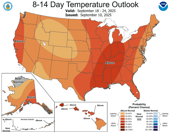
Figure 1. The Climate Prediction Center’s 8 to 14-day temperature forecast, valid for the period September 18-24, 2025.
Does an above-normal forecast like this suggest Kansas’ first frost and freeze will be delayed? Not necessarily. It only takes one chilly airmass to bring a killing freeze. Medium-range forecasts don’t contain any information regarding the probability of an early-season, singular, short-lived cold-air outbreak; these are impossible to accurately predict well in advance. In October, keep an eye on the 6-to-10 and 8-to-14-day outlooks. Watch for higher probabilities of cooler-than-normal temperatures, as these can suggest a threat for frost and freezing conditions.
The Kansas Mesonet (https://mesonet.k-state.edu) is a great resource to track temperature data. When you visit, you’ll find a Freeze Monitor page with information regarding the number of hours each Mesonet site has spent below freezing and sub-freezing thresholds. Fortunately, we have a few more weeks to prepare for the arrival of freezing conditions, but the journey towards frosty mornings has begun; we’re already headed for colder temperatures as the normal highs and lows drop a little bit each day.
Matthew Sittel, Assistant State Climatologist
msittel@ksu.edu