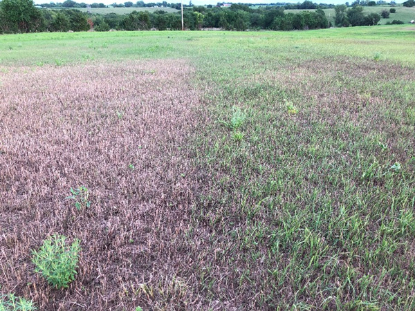
Fall armyworms (FAW) are destructive pests to various Kansas crops, including corn, sorghum, wheat, alfalfa, and cool and warm-season grass forages. They feed rapidly on the leaf area of plants, reducing the active photosynthetic area and slowing plant growth. The FAW make their appearance in mid to late July, eat incredibly large amounts of grassy material, and caterpillars not killed by timely applications have likely pupated. This leads to another generation capable of damage, as they will not be killed until frost. Severe FAW infestation cases lead to stand losses (Figure 1). Therefore, regular field scouting is required for early detection and timely management before it leads to severe loss. Scouting and monitoring can be done using a combination of both visual inspection of the field and remote sensing technology by using satellite imagery.
For example, satellite imagery can identify a stressed area in the field, but it does not show causation. This imagery can guide field scouting to ground truth the issue. FAW are small and require the human eye for identification and determining the presence level. Stressed areas detected with satellite imagery can be used to determine if a pattern is random or uniform, as seeing an entire field from the ground is often difficult. Hot spots, or continuously stressed areas, can be found and receive targeted scouting for improved efficiency.

Figure 1. Fall armyworm infestation in a brome field showing distinct brown patches of damaged forage compared to adjacent healthy green growth. Such visible damage highlights the importance of regular monitoring and early detection. Photo by David Hallauer, K-State Research and Extension.
Satellite Imagery
Various freely available and commercial satellite imagery can be used to monitor the FAW infestation. Different satellites provide different spatial, spectral, and temporal resolutions of the satellite imagery. For example, Sentinel-2 provides free imagery with a resolution of 10-meter pixel size every 5 days for the entire Earth and has 10 different bands of information. Similarly, Planet Scope is commercial satellite imagery that provides 3-meter resolution imagery daily. Such moderate to high resolution imagery can be useful to track the FAW infestation, pest movement pattern, and early outbreak by using different indices such as NDVI (Normalized Difference Vegetation Index) using the equation below:

The NDVI value of the crop normally ranges from 0 to 1. When the crop is FAW-free, it is green, healthy, and has dense green foliage, which usually results in a higher NDVI value. However, when FAW feeds on crops, their leaves are striped, reducing canopy density, leaving stems bare and green, resulting in a lower NDVI value. FAW larvae usually infest the fields by gathering or clustering in the fields instead of spreading out scattered. Therefore, NDVI maps can be used to identify such clusters of worms and their patchy damage.
A real case scenario
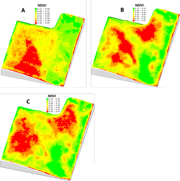
A FAW-infested brome field in eastern Kansas was monitored using a higher resolution commercial PlanetScope satellite, which has a spatial resolution of 9.84 feet (3 m) pixel size. The first image from July 27 (Figure 2a) shows red or low NDVI patches in the southern to central part of the field. Such red patches expanded further to the central and northern parts of the field. FAW clusters feed in a marching pattern, reducing the leaf area of smooth brome (Figure 2b). Such infestation expanded further, with red and yellow irregular patches almost throughout the field (Figure 2c). Satellite imagery, as shown, can be effectively used to identify the hot spot FAW areas and track their feeding march. Since FAW exhibits a moving patchy pattern in the field, they can be separated from other moisture or nutrient stress, as they usually have a uniform pattern throughout the field. However, visiting such low NDVI spots to confirm the presence of FAW is preferred.

Figure 2. NDVI maps of a brome field derived from Planet Scope satellite imagery on (A) July 27, (B) August 8, and (C) August 19. Progressive development of patchy low-NDVI areas (red zones) indicates increasing canopy damage associated with fall armyworm infestation. Images by Deepak Joshi, K-State Research and Extension.
Conclusion
Regular scouting and monitoring for fall armyworms are critical for timely management. The information from satellite imagery, when combined with field scouting, provides more accurate information. This imagery can identify the stressed patches and their proximity and size in a field. The scouting efforts can then be focused on these satellite-found areas to determine FAW presence and pressure, or if the lower productivity is due to other factors. However, satellite imagery can be used from the start of crop growth to flag potential stress hotspots. These hotspots can then be prioritized for targeted scouting, leading to earlier FAW detection, better use of resources, and more effective pest management.
Deepak Joshi, Precision Ag Extension Specialist
drjoshi@ksu.edu
Logan Simon, Southwest Area Agronomist
lsimon@ksu.edu
Tina Sullivan, Northeast Area Agronomist
tsullivan@ksu.edu
Anthony Zukoff, Extension Entomology - Garden City
azukoff@ksu.edu
Tags: crop scouting fall armyworms precision agriculture satellite imagery