We have reached the end of meteorological summer; it concluded on August 31. But you wouldn’t know it, given the recent temperatures. On August 24th, southwest Kansas was baking in triple-digit heat. Leading the way was Medicine Lodge, where the high temperature was a sizzling 115°. Not only was this the hottest temperature in the state this year, but it was also the hottest day in Medicine Lodge in 70 years! Other locations had their hottest day of the year last week, including Ashland (111° on Aug. 24), Dodge City (106°, Aug. 25), Manhattan (104°, Aug. 25) and Topeka (102°, Aug. 26). With temperatures this hot, it certainly doesn’t feel like summer is about to come to an end. But there is an unmistakable sign that cooler weather is surely on its way. Average daily highs and lows have begun their retreat from their summertime maxima. You might be surprised to find out that the start of the decline was a few weeks ago. For example, Dodge City’s average high for August 30 is 89°, down 5 degrees from its peak of 94° in late July. The descent into cooler readings is slow at first but increases more rapidly in autumn. In this report, we look at the timeline for the annual arrival of cooler days and nights and when, during the fall, average highs and lows reach various thresholds.
On September 1, the first day of meteorological fall, average high temperatures across the state range from 84° in northeast to 88° in southwest and south central Kansas. Highs in the 90s are occasionally common in early September and even triple-digit heat. Last year, Dodge City hit 101° on September 1, and Goodland reached 100°. But highs this warm become less likely as the month progresses. Manhattan, for example, has only reached 100° a dozen times on or after September 16th in their 131-year climate record. By the end of September, average highs are in the mid and upper 70s statewide. During October, daily averages fall more rapidly; the rate of decrease is nearly half a degree per day. By Halloween, highs are normally in the low to mid-60s. Come Thanksgiving, daytime highs average only in the low 50s. Table 1 lists the average dates each of Kansas’ nine climate divisions reach thresholds starting at 85° and decreasing by five down to 50°.
Table 1. Dates when divisional average daily high temperatures fall to the thresholds listed at the top and bottom of each column.
|
Division |
85 °F |
80 °F |
75 °F |
70 °F |
65 °F |
60 °F |
55 °F |
50 °F |
|
1 – Northwest |
Sep 5 |
Sep 19 |
Sep 30 |
Oct 11 |
Oct 22 |
Nov 2 |
Nov 13 |
Nov 24 |
|
2 – North Central |
Sep 4 |
Sep 19 |
Oct 1 |
Oct 12 |
Oct 23 |
Nov 2 |
Nov 13 |
Nov 23 |
|
3 – Northeast |
Aug 29 |
Sep 15 |
Sep 29 |
Oct 11 |
Oct 22 |
Nov 2 |
Nov 12 |
Nov 23 |
|
4 – West Central |
Sep 6 |
Sep 21 |
Oct 2 |
Oct 13 |
Oct 24 |
Nov 4 |
Nov 15 |
Nov 27 |
|
5 – Central |
Sep 8 |
Sep 22 |
Oct 4 |
Oct 15 |
Oct 26 |
Nov 6 |
Nov 17 |
Nov 27 |
|
6 – East Central |
Sep 1 |
Sep 16 |
Sep 30 |
Oct 12 |
Oct 24 |
Nov 4 |
Nov 15 |
Nov 26 |
|
7 – Southwest |
Sep 13 |
Sep 26 |
Oct 8 |
Oct 19 |
Oct 30 |
Nov 10 |
Nov 21 |
Dec 3 |
|
8 – South Central |
Sep 11 |
Sep 24 |
Oct 6 |
Oct 18 |
Oct 29 |
Nov 9 |
Nov 20 |
Dec 1 |
|
9 - Southeast |
Sep 6 |
Sep 21 |
Oct 4 |
Oct 17 |
Oct 29 |
Nov 9 |
Nov 20 |
Dec 2 |
Table 2 lists average dates for low temperatures at thresholds ranging from 65° down to 30°. On September 1, averages range from 57° in northwest to 64° in southeast Kansas. These lows are 5 to 7 degrees lower than their mid-summer peak values. Cooler nights are the rule by month’s end, as average lows on September 30 range from the mid-40s to the low 50s across the state. Like high temperatures, low temperatures during October drop nearly half a degree daily.
Concerns over a killing freeze are on the minds of everyone with agricultural interests by mid-month. Last year, Wichita’s first freeze was on October 30, and a low of 23° on the 31st marked the end of the growing season. The previous year, Wichita’s first freeze was much earlier, on October 18. By Halloween, the poetic sight of “frost on the pumpkin” has often become a reality, as lows on October 31 average near freezing in the northwest and west central Kansas and are in the 30s everywhere but southeast Kansas, where the average low is still 40°. Nights grow ever longer in November, and low temperatures continue to cool. By November 22, average lows are at or below freezing in every division in the state, and normal lows range from 21 to 29 degrees by month’s end.
Table 2. Dates when divisional average daily low temperatures fall to the thresholds listed at the top and bottom of each column. A * indicates a division in which the low temperature never averages above the threshold value during the year.
|
Division |
65 °F |
60 °F |
55 °F |
50 °F |
45 °F |
40 °F |
35 °F |
30 °F |
|
1 – Northwest |
* |
Aug 22 |
Sep 7 |
Sep 19 |
Sep 30 |
Oct 10 |
Oct 22 |
Nov 3 |
|
2 – North Central |
Aug 12 |
Sep 1 |
Sep 15 |
Sep 27 |
Oct 8 |
Oct 19 |
Oct 30 |
Nov 11 |
|
3 – Northeast |
Aug 18 |
Sep 5 |
Sep 18 |
Sep 30 |
Oct 12 |
Oct 24 |
Nov 5 |
Nov 19 |
|
4 – West Central |
* |
Aug 24 |
Sep 9 |
Sep 21 |
Oct 2 |
Oct 12 |
Oct 23 |
Nov 5 |
|
5 – Central |
Aug 18 |
Sep 6 |
Sep 19 |
Sep 30 |
Oct 11 |
Oct 22 |
Nov 3 |
Nov 16 |
|
6 – East Central |
Aug 23 |
Sep 8 |
Sep 21 |
Oct 3 |
Oct 15 |
Oct 28 |
Nov 10 |
Nov 23 |
|
7 – Southwest |
Aug 6 |
Aug 31 |
Sep 15 |
Sep 26 |
Oct 7 |
Oct 17 |
Oct 29 |
Nov 11 |
|
8 – South Central |
Aug 24 |
Sep 10 |
Sep 22 |
Oct 4 |
Oct 15 |
Oct 26 |
Nov 8 |
Nov 21 |
|
9 - Southeast |
Aug 27 |
Sep 12 |
Sep 24 |
Oct 6 |
Oct 18 |
Oct 31 |
Nov 13 |
Nov 28 |
Fall weather outlooks for Kansas
What will autumn 2024 hold for Kansas? It’s too soon to say with any certainty. Still, the most recent seasonal outlook for the fall months, issued by NOAA’s Climate Prediction Center in mid-August, favors above-normal temperatures for the state, particularly in western Kansas (Figure 1). But this doesn’t mean that a delay in the occurrence of a first frost and freeze is a guarantee. It only takes one chilly airmass to bring a killing freeze. In the case of Wichita, after the October 18th first freeze in 2022, it was over three weeks until the second sub-freezing day was recorded on November 11. Seasonal forecasts don’t contain any information regarding the probability of an early season, singular, short-lived cold air outbreak; these are impossible to predict well in advance accurately. Keep an eye on shorter-lead forecasts such as the 6 to 10 and 8 to 14-day outlooks in October. Watch for high probabilities of cooler-than-normal temperatures, often indicating a threat of frost and freezing conditions. The Kansas Mesonet website (https://mesonet.k-state.edu) is also a great resource for tracking temperature data. When you visit the site, you’ll find a Freeze Monitor page with information regarding the hours each Mesonet site has spent below freezing and sub-freezing thresholds. No site has recorded a low in the 40s since July 1 yet, so there’s nothing but zeroes at the moment, but now is a good time to familiarize yourself with the page so you can refer back to it this fall. Fortunately, we have a few more weeks to prepare for the arrival of freezing conditions. However, the autumnal journey has begun; we’re already heading for colder weather as the daily normal highs and lows drop a little bit each day.
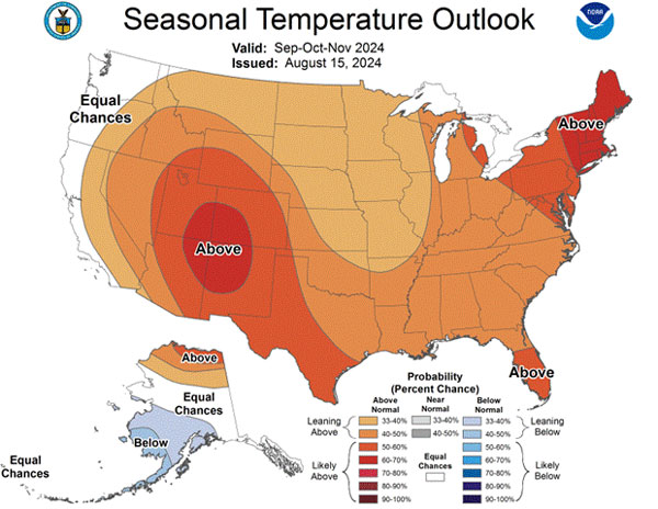
Figure 1. The Climate Prediction Center’s seasonal temperature forecast for the month of September through November 2024, issued on August 15.
Matthew Sittel, Assistant State Climatologist
msittel@ksu.edu