The Kansas Ag-Climate Update is a joint effort between our climate and extension specialists. Every month the update includes a brief summary of that month, agronomic impacts, relevant maps and graphs, 1-month temperature and precipitation outlooks, monthly extremes, and notable highlights.
May 2022: Water supply significantly increased in the eastern region of Kansas
Statewide average temperature in May was 0.8oF above normal, with an average temperature of 64oF across the state (Fig. 1). Central and western Kansas had the larger temperature departures, which made the drought conditions worse in May. From a climate perspective, the entire wheat season (October 2021 to May 2022) was the warmest since 2017.
Climatologically, May has the highest precipitation amount of any month, with a 30-year average of 4.3 inches in Kansas. This May was wetter than usual across the state (1.3 inches higher than normal) -- especially in the central and eastern portions of the state (3 inches higher than normal in the east) (Fig. 1). Still, when considering the 8-month accumulated precipitation (October to May) for wheat growth, crop-season precipitation was the driest since 2018. This certainly has the potential to affect wheat grain yields this year.
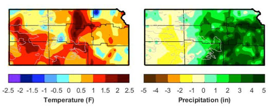
Figure 1. Departures from normal temperature (°F) and precipitation (inches) for May 2022.
View the entire May 2022 Ag-Climate Update, including the accompanying maps and graphics (not shown in this short summary), at http://climate.k-state.edu/ag/updates/
Xiaomao Lin, State Climatologist
xlin@ksu.edu