Soil moisture and precipitation
Current status
Current moisture status at 2” depth (5 cm) across Kansas is slightly wet on the east side of the state, with severe dry conditions for much of the west (Figure 1). The last two weeks have provided little widespread precipitation with below normal amounts for most of the state except a narrow band in the east (Figure 2).
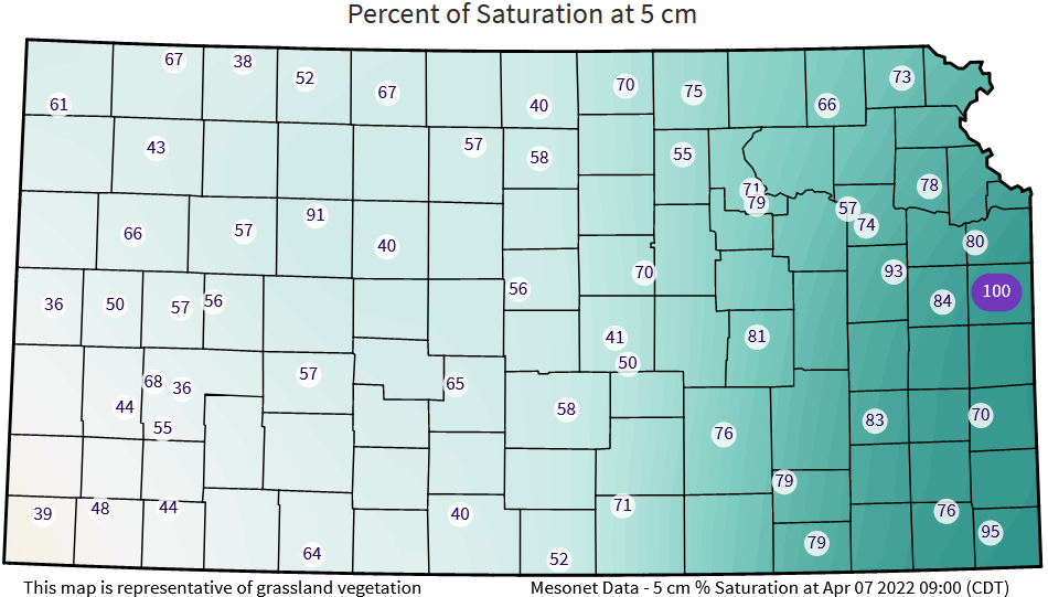
Figure 1. Soil moisture as % of saturation at 0-5 cm layer as of April 7, 2022 (Kansas Mesonet).
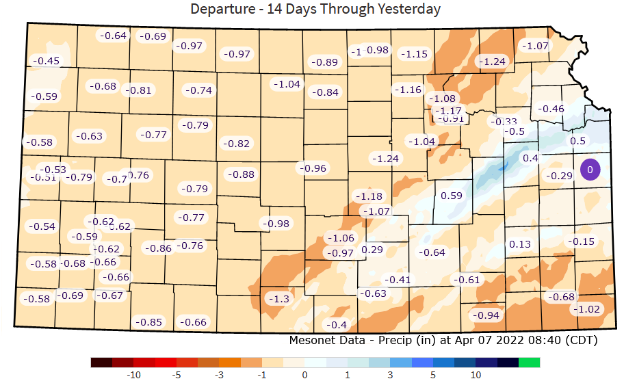
Figure 2. Departure from normal precipitation for the 14 days ending April 7 , 2022.
Precipitation projections
Short-term outlook (8-14 days)
Very dry and windy conditions brought in April. These conditions are notorious for decreasing soil moisture across the state. In addition, dry conditions are favored into mid-late April with a 40% probability of below normal precipitation (Figure 3).
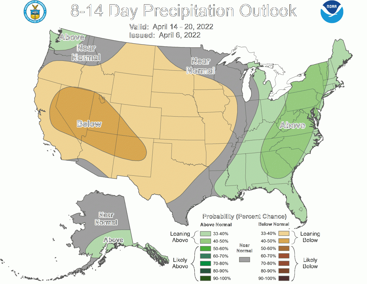
Figure 3. Short-term (8 to 14-day) outlook precipitation probability for April 14 – April 20, 2022. Source: NOAA.
Seasonal outlook (April-May-June)
Following a similar trend, projections for the April-May-Jun period indicate a high probability of below-normal, particularly more likely towards the southwest region of the state (Figure 4).
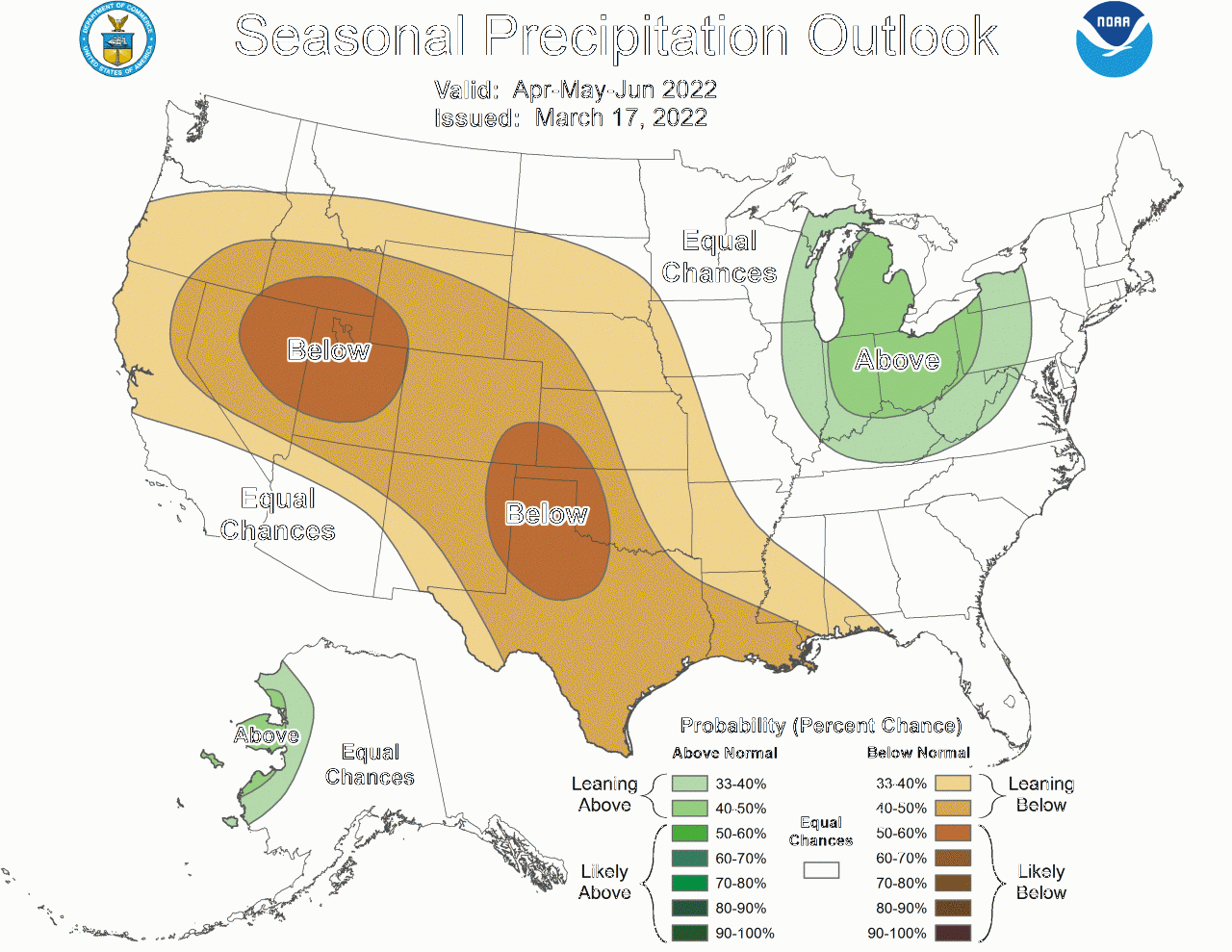
Figure 4. Seasonal outlook precipitation probability for April-May-June 2022. Source: NOAA.
Temperature
Current status
For the first week of April, average soil temperatures at 2 inches among crop reporting districts ranged from 43oF to 56oF, with a trend of the coolest temperatures in the northeast and the warmest towards the southwest corner of the state (Figure 5). Soil temperature varies based on local soil moisture, residue, and soil types. For instance, the weekly average at WaKeeney is 50oF, while it is 45oF at the Sheridan Mesonet.
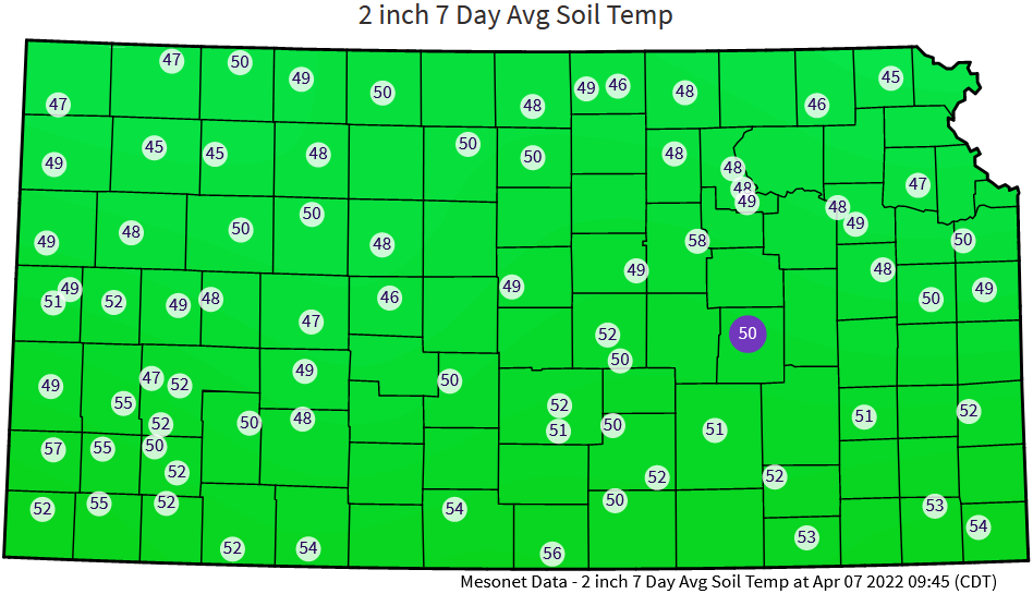
Figure 5. Average soil temperatures at 2-inch soil depth for the week of March 31-April 7, 2022. Source: Kansas Mesonet (http://mesonet.k-state.edu/).
Temperature projections
Short-term outlook (8-14 days)
Temperature projections call for a statewide cooler-than-normal outlook (Figure 6). This will slow the process of warming up the soils for planting. Remember that wet soils under a no-tillage system will be slower to warm, while dry soils will fluctuate more rapidly, matching air temperatures, particularly if skies are clear.
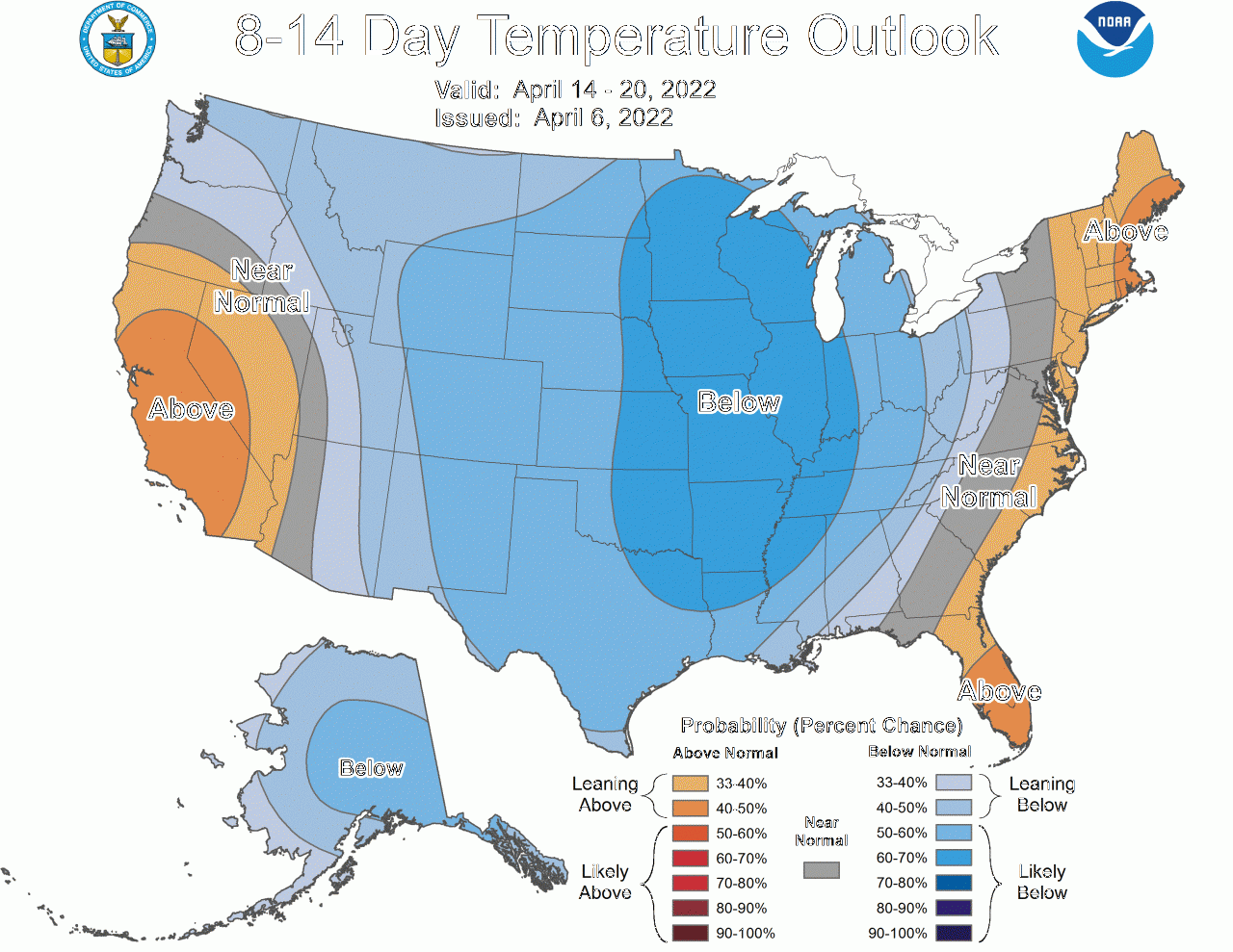
Figure 6. Short-term (8 to 14-day) outlook precipitation probability for April 8 – April 14, 2022. Source: NOAA.
As for the long-term projection on temperatures (April, May, and June), the outlook portrays a situation with most likely above temperatures for the entire state of Kansas (Figure 7).
Seasonal outlook (April-May-June)
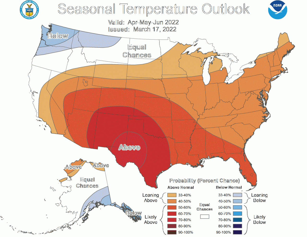
Figure 7. Seasonal outlook precipitation probability for April-May-June 2022. Source: NOAA.
Optimal soil temperature for crop emergence
Every summer row crop has an optimal soil temperature for emergence. A minimum for corn is 50 oF for germination and early growth. However, uniformity and synchrony in emergence is primarily achieved when soil temperatures are above 55 oF for corn and above 60 oF for soybeans. Uneven soil temperatures around the seed zone can produce non-uniform crop germination and emergence. Lack of uniformity in emergence can greatly impact corn potential yields. This is particularly true for corn, since it is the earliest summer row crop planted. When soil temperatures remain at or below 50 oF after planting, the damage to germinating seed can be particularly severe.
Impact of a hard freeze on corn
Corn is also more likely than other summer crops to be affected by a hard freeze after emergence if it is planted too early. The impact of a hard freeze on emerged corn will vary depending on how low the temperature gets, the intensity and duration of the low temperatures, field variability and residue distribution, tillage systems, soil type and moisture conditions (more severe under dry conditions), and the growth stage of the plant. Injury is most likely on very young seedlings or on plants beyond the V5-6 growth stage, when the growing point is above the soil surface.
The average day for last spring freeze (32 oF) is quite variable around the state (Figure 10). The largest variability is from southeast to northwest Kansas; with the earliest last spring freeze date for the southeast region (April 5-15) and latest for the northwest area (>May 3). Corn planting dates before April 15 in the southeast region would increase the likelihood of the crop suffering from a late spring freeze. Similar conditions can be projected for northwest Kansas if corn is planted before May 3 (Figure 8).
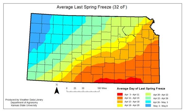
Figure 8. Average last spring freeze (32 degrees F) for Kansas.
Producers should consider all these factors when deciding on the optimal planting time.
‘Reminder of the 2012 season’
The above-detailed weather outlook for the 2022 season brings some memories from the 2012 season, one of the driest and warmest during the last decades. Thus, if current weather projections are realized, yields for summer row crops will be compromised during the coming season. Adjust your use of inputs (seeding rate, fertilizer) based on yield target expectations.
More information about the planting status of summer row crops will be provided in upcoming issues of the Agronomy eUpdate. Stay tuned!
Ignacio Ciampitti, Farming Systems
ciampitti@ksu.edu
Adrian Correndo, Postdoctoral Fellow
correndo@ksu.edu
Christopher “Chip” Redmond, Kansas Mesonet Network Manager
christopherredomond@ksu.edu