The Kansas Ag-Climate Update is a joint effort between our climate and extension specialists. Every month the update includes a brief summary of that month, agronomic impacts, relevant maps and graphs, 1-month temperature and precipitation outlooks, monthly extremes, and notable highlights.
November 2021: A warm ending towards dry condition
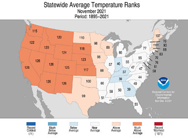
Statewide average temperature for the month was 46 oF, which is 3.5 oF warmer than normal. The normal temperature in the west is usually colder than the east region but this month’s average temperatures were uniform across the state. This November was warmer than last year’s November. Overall, the last three months together have been the coolest since 2014. There were only 3 record high daytime temperatures in western Kansas. The statewide average temperature ranked 117th (Figure 1).
Precipitation anomaly was slightly drier on average across the state. The normal precipitation gradient is from 0.6” in the west to 2” in the east. The eastern regions, especially SE region, were drier at -1.2” below normal. Statewide average precipitation for the month was 1.3 inches, about 0.9 inches drier than normal. If we consider the last three months (September to November), the fall season’s preciption was a normal season.

Figure 1. Statewide average temperature ranks for November 2021. Source: NOAA
View the entire November Ag-Climate Update, including the accompanying maps and graphics (not shown in this short summary), at http://climate.k-state.edu/ag/updates/.