Scientists with the National Center for Atmospheric Research (NCAR) stated in a recent press release that a Super El Niño will likely occur this winter. The name conjures up images of a meteorological superhero; as it turns out, a Super El Niño could be a hero for Kansans. This article discusses El Niño, what it takes for an ordinary El Niño to be called super, and how it might affect Kansas’ weather.
What is a regular El Niño?
El Niño conditions occur when there are extended periods of above-normal sea surface temperatures in the equatorial Pacific Ocean. Scientists at NOAA identified a specific part of the Pacific Ocean to use when determining if there is an El Niño event: a box extending from 5°N to 5°S latitude and from 120°W to 170°W longitude. This box even has a name: Niño 3.4. There are other Niño boxes in the Pacific, numbered 1, 2, 3, and 4, and 3.4 gets its name because it contains parts of both Niño 3 and Niño 4 (Figure 1).
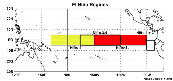
Figure 1. The bounds of Niño regions used in determining El Niño conditions. Source: NOAA.
NOAA also has a specific definition regarding how much above normal sea surface temperatures must be and for how long to be classified as an El Niño event. Sea surface temperatures inside the Niño 3.4 region must average at least 0.5°C (0.9°F) above normal for five consecutive three-month periods to be classified as an El Niño. Each three-month period overlaps with the one before and after it. For example, November-December-January (NDJ for short, using the first letter of each month’s name) comes before December-January-February (DJF), but each share two consecutive months with the other. Thus, five consecutive three-month periods include parts of seven consecutive calendar months. The opposite event, La Niña, is defined the same way, only the threshold is the negative of the one for El Niño: less than -0.5°C (-0.9°F).
To simplify things, scientists created an index that describes the average sea surface temperature anomalies across the entire box: the Oceanic Niño Index, or ONI. Since each Niño box can have its own ONI, the number of the box inside which the ONI was calculated becomes part of the name of the index, so for El Niño classification, the index used to make that determination is called ONI 3.4.
What is a Super El Niño?
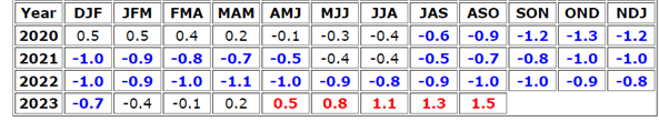
There is a single ONI 3.4 value that covers each three-month period, based on weekly values that are averaged together since, just like air temperature, sea surface temperatures fluctuate from week to week and from location to location. The most recent ONI 3.4 reading for August-September-October (ASO) of 2023 was +1.5°C. Since this was the fifth consecutive three-month period with an ONI greater than or equal to +0.5°C, we are officially in an El Niño phase for the first time since 2018-19 (Table 1). You may recall that before this, last year, scientists and the media talked about a “Triple Dip La Niña,” which occurred when we had three consecutive years with La Niña conditions. This El Niño event is getting stronger as the ONI 3.4 value increases. If the three-month average ONI 3.4 reaches +2.0°C, this current El Niño event will be dubbed a Super El Niño. The NCAR press release stated that one of their models forecasts a peak ONI 3.4 of +2.4°C this winter. Until this threshold is reached, we could consider ourselves under a “Super El Niño Watch.”
Table 1. Three-month average ONI 3.4 values since 2020. Source: NOAA’s Climate Prediction Center.
How does a Super El Niño affect Kansas?
Should we be concerned if the Super El Niño Watch gets upgraded to a Warning (which will happen if a future ONI 3.4 three-month index reaches +2.0°C)? Not at all! Kansans should root for a Super El Niño to occur, especially this year, because we tend to get more precipitation in Kansas during El Niño events, and given the drought conditions plaguing the state, any additional rainfall would be welcome. Let’s look back at what has happened in Kansas during previous El Niño events.
The beginning of historical ONI 3.4 records started in 1950. We can classify each winter since 1950 as El Niño, La Niña, or neither (“neutral”) by applying the five consecutive three-month periods ONI 3.4 data threshold discussed earlier and by including a requirement that the ONI 3.4 value for the winter months of December, January, and February (DJF) be one of those five periods. We looked at monthly precipitation provided by NCEI, the National Centers for Environmental Information. NCEI has archived average monthly precipitation back to 1895, and there are no missing years in their data record, so that we can examine all 73 winters between 1950-51 and 2022-23.
Of the 73 winters since 1950, based on the ONI 3.4 criteria, 21 are classified as El Niño, 19 as La Niña, and the remaining 33 are neutral winters. When we sum up the DJF precipitation totals for all occurrences of each of the three events, we see there is a tendency for Kansas to receive more winter precipitation during El Niño events (Table 2). During an El Niño winter, Kansas averages about 0.4 inches more precipitation than in a neutral winter. Interestingly, La Niña winters also average more precipitation than neutral events but less precipitation during El Niño winters.
Table 2. Average December-February precipitation during El Niño, La Niña, and neutral events.
|
Event |
# of Winters |
Average DJF Precipitation (inches) |
|
El Niño |
21 |
2.72 |
|
Neutral |
33 |
2.34 |
|
La Niña |
19 |
2.48 |
We can further examine precipitation during El Niño winters and see if there is more precipitation during strong El Niño events than during weak events. Suppose we change the minimum ONI 3.4 threshold to be higher than +0.5°C and average winter precipitation for the stronger El Niño events that meet the more stringent requirement. Do we see a tendency towards even higher precipitation? When we classify by this method (Table 3), we see that there is a tendency for precipitation to increase even more as the ONI 3.4 threshold increases. The last line in Table 3 is the threshold for Super El Niño events. Since 1950, there have been only five El Niño events during which the ONI reached at least +2.0°C. These were in the following years: 1965-66, 1972-73, 1982-83, 1997-98 and most recently in 2015-16.
Table 3. Average December-February precipitation for El Niño events of varying magnitudes.
|
ONI 3.4 El Niño Threshold |
El Niño Events |
Average DJF Precipitation (inches) |
|
≥ +0.5°C |
21 |
2.72 |
|
≥ +1.0°C |
14 |
2.75 |
|
≥ +1.5°C |
9 |
3.17 |
|
≥ +2.0°C |
5 |
3.49 |
It does appear that the stronger the El Niño event, the more precipitation Kansas gets on average. Those last two words are key. On average, it does not mean every year was above normal. There are La Niña and neutral years that had above-normal precipitation, and there were also El Niño years with below-normal precipitation. There is no guarantee that a Super El Niño event will result in above-normal precipitation if it happens this winter. Still, the averages suggest reason to be optimistic should a Super El Niño occur.
Matthew Sittel, Assistant State Climatologist
msittel@ksu.edu