The first month of 2023 has drawn to a close. In this report, we take a look back at what was a warm, wet January at many locations, except for northwest Kansas where it was cold and snowy. Also, the Climate Prediction Center has released their one-month temperature and precipitation outlooks for February 2023.
Weather systems across Kansas in January
It was a mild start to the year, with a storm system more characteristic of early spring than winter affecting the state on January 2. Snow fell in the far northwest, with rain and thunderstorms in the east. A period of mild weather followed this system for most areas, but the snow that fell early in the month was slow to melt, keeping the northwest cooler than the rest of Kansas, but still above seasonal normals through mid-month.
In the second half of January, three separate storm systems affected Kansas in the span of just over a week, bringing ample precipitation to the entire state, resulting in above normal monthly totals for many areas (Figure 1). With the first event on January 17-18, snow fell in the northern part of the state, while it was a soaking rain in the east, with sleet mixed in at a few locations. The second event was mainly on the 21st, which brought snow to more areas, particularly in the northern two-thirds of Kansas. The third precipitation event was on the 24th and 25th, which fell in the form of both rain and snow, and was focused on the southeastern half of the state. Late in the month, a strong cold front swept across the state, bringing much colder air. Lows in the single digits above and below zero were common in all but southeast Kansas on the 29th and 30th, with daytime highs remaining well below freezing. This brought final average readings for the month down a couple degrees, but for most areas the monthly mean temperature was still well above normal (Figure 2).
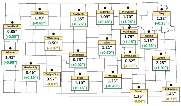
Figure 1. Total precipitation for January 2023 for select locations in Kansas. Values in parentheses are the departures from normal. Normals are based on the period 1991-2020.
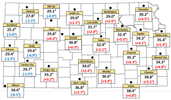
Figure 2. Average temperatures for January 2023 for select locations in Kansas. Values in parentheses are the departures from normal.
While no areas experienced their warmest, wettest or snowiest January on record, there were some places that experienced a top 10 event in each of those categories. It was the 4th warmest January on record in Emporia (35.3°F, 74 years of record keeping). Chanute (38.8°F, 130 years) had their 10th warmest January on record. Meanwhile, Goodland had a monthly average temperature of 25.2°F, 5.0°F below normal. While not top 10, this ranks as the 23rd coldest January on record, dating back to 1888. It was even colder in our northwesternmost county in Kansas. The Kansas Mesonet site in Cheyenne County had an average temperature of 23.4°F, aided in part by a low of -11° on the 30th, the coldest temperature recorded in the state for the entire month of January. Compared to the normal temperatures at nearby St. Francis, this average was 6.0° below normal. Many locations in Kansas had much higher rankings on the list of warmest Januarys through the first three weeks of the month. It was the last 10 days that brought normal temperatures down significantly.
January 2023 was the 4th wettest on record in Greensburg (2.02”, 115 years of record keeping) and Tribune (1.41”, 116 years). It was the 5th wettest January at both Plainville (1.51”, 112 years) and McPherson (2.03”, 130 years). The 1.79 inches at Manhattan’s co-op site on the K-State campus tied for the 7th wettest January out of 129 years on record. Manhattan’s January total was 0.01” greater than the averages for both January and February combined! Goodland’s 0.85” ranked as the 10th wettest January out of 116 years. In addition, Goodland’s 15.9” of snow was their 4th snowiest January in 113 years, and the snowiest January since 1988. Looking at just January 1-21, it was the 2nd warmest on record at Emporia, 3rd warmest at Chanute, 5th warmest at both Wichita and Topeka, and 9th warmest at Manhattan (Table 1). By contrast, the last 10 days of January ranked as 6th coldest on record at Garden City and 10th coldest at Goodland.
Total snowfall values across the state is shown in Figure 3. Additionally, Tables 1 through 3 summarize the average temperatures, highest precipitation, and snowfall amounts across at various locations in Kansas.
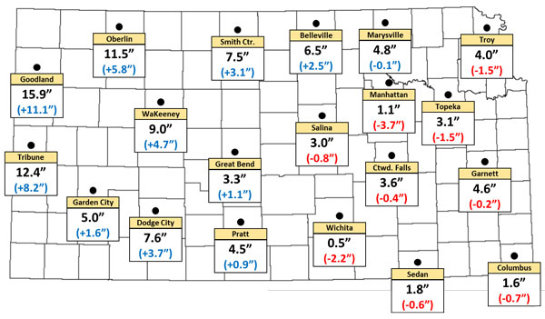
Figure 3. Total snowfall for January 2023 for select locations in Kansas. Values in parentheses are the departures from normal. Normals are based on the period 1991-2020.
Table 1. Average temperatures for select Kansas locations. Normals are based on the years 1991-2020. Red shaded cells are above normal; blue shaded cells are below normal.
|
|
Average Temperature (Departure from Normal) |
|||
|
Location |
County |
Jan. 1-21 |
Jan. 22-31 |
Jan. 1-31 |
|
Goodland |
Sherman |
29.3° (-0.7°) |
16.7° (-13.4°) |
25.2° (-5.0°) |
|
Hill City |
Graham |
33.3° (+0.3°) |
20.3° (-9.9°) |
29.1° (-1.0°) |
|
Salina |
Saline |
36.9° (+6.5°) |
24.6° (-6.7°) |
32.9° (+2.1°) |
|
Manhattan |
Riley |
35.5° (+6.5°) |
25.9° (-3.6°) |
32.4° (+3.3°) |
|
Topeka |
Shawnee |
37.5° (+7.4°) |
27.5° (-3.0°) |
34.3° (+4.1°) |
|
Garden City |
Finney |
34.8° (+3.8°) |
19.1° (-12.9°) |
29.7° (-1.5°) |
|
Dodge City |
Ford |
38.5° (+5.8°) |
21.9° (-11.7°) |
33.2° (+0.2°) |
|
Wichita |
Sedgwick |
40.5° (+7.5°) |
28.4° (-5.4°) |
36.6° (+3.4°) |
|
Emporia |
Lyon |
39.0° (+8.0°) |
27.5° (-3.9°) |
35.3° (+4.3°) |
|
Chanute |
Neosho |
42.5° (+8.9°) |
31.1° (-3.1°) |
38.8° (+5.1°) |
Table 2. Top 10 monthly precipitation totals for January 2023 as reported by Kansas CoCoRaHS observers.
|
Rank |
Location |
County |
Precip. (inches) |
|
1 |
Olathe 1.6 NNE |
Johnson |
3.18 |
|
2 |
Olathe 3.5 NW |
Johnson |
2.61 |
|
3 |
Baldwin City 0.6 W |
Douglas |
2.59 |
|
4 |
Parsons 0.8 SE |
Labette |
2.56 |
|
5 |
Williamsburg 1.5 WSW |
Franklin |
2.48 |
|
6 |
Overland Park 1.7 NE |
Johnson |
2.41 |
|
7 |
McPherson 1.1 NW |
McPherson |
2.41 |
|
8 |
Ottawa 5.6 SW |
Franklin |
2.40 |
|
9 |
Garnett 0.4 NNE |
Anderson |
2.35 |
|
10 |
Greeley 3.6 NE |
Franklin |
2.33 |
Table 3. Top 10 monthly snowfall totals as reported at Kansas observing sites.
|
Rank |
Location |
County |
Snow (inches) |
Network |
|
1 |
Goodland WFO |
Sherman |
16.4” |
COOP |
|
2 |
Goodland Renner Field |
Sherman |
15.9” |
WBAN |
|
3 |
Goodland 0.5 ENE |
Sherman |
15.1” |
CoCoRaHS |
|
4 |
Atwood |
Rawlins |
14.6” |
COOP |
|
5 |
Goodland 16.6 NW |
Sherman |
14.5” |
CoCoRaHS |
|
6 |
Grainfield |
Gove |
13.8” |
COOP |
|
7 |
Wallace |
Wallace |
13.3” |
COOP |
|
8 |
Goodland 10.3 WNW |
Sherman |
13.2” |
CoCoRaHS |
|
9 |
Goodland 12.1 NW |
Sherman |
13.2” |
CoCoRaHS |
|
10 |
Oakley 0.3 NE |
Logan |
13.1” |
CoCoRaHS |
February weather outlook for Kansas
Will February be anything like January? The latest outlooks (Figures 4 and 5) from the Climate Prediction Center call for equal chances of below normal, above normal and near normal temperatures across the entire state. There is a slightly higher chance for above normal precipitation for southeast Kansas, while the rest of the state has an equal chance for above normal, below normal and near normal precipitation. Let’s hope that the wet start to 2023 is just the beginning of a year that will be remembered for more precipitation and not less. Kansas still has a significant precipitation deficit in many areas.
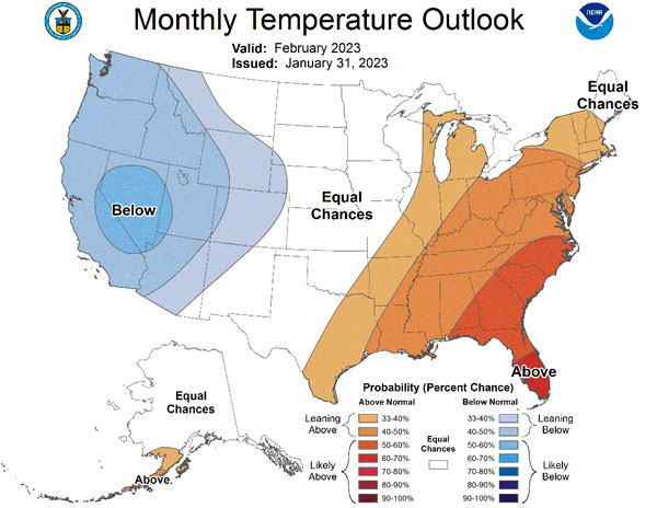
Figure 4. The Climate Prediction Center’s temperature outlook for February 2023.
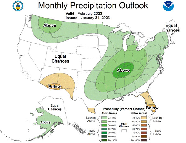
Figure 5. The Climate Prediction Center’s precipitation outlook for February 2023.
Matthew Sittel, Assistant State Climatologist
msittel@ksu.edu