Fire season 2022 never went away in Kansas. In fact, fire activity has occurred every month this calendar year. Large fires have already occurred this fall, however, the official start of Kansas fire season is typically considered a few days following the first freeze. The beginning of this week (October 16-17) featured the first freeze statewide and most of the vegetation/fuels are now available. Additionally, we need to consider a few factors on the upcoming dormant fire season in Kansas through spring.
Fuel for the fire
The vegetation landscape across Kansas varies by each growing season. The primary fuel (burnable material) of wildfires in Kansas is grass. The amount of growth can vary greatly depending on location, precipitation, soil type, and land management practices. Unfortunately, much of the state was in drought this year. Areas in western Kansas, specifically around Scott County and Rawlins County never observed native grass green-up this summer. Therefore, any fuel residing across the landscape was carried over from last year. Elsewhere, despite sudden onset drought and heat during the summer, the Flint Hills region especially, observed above-normal moisture during the primary growth season of April through June (Figure 1). This has likely resulted in higher than normal fuel loading with more available perennial grass to burn. Therefore, increased fire behavior is possible in this region with any fire activity.
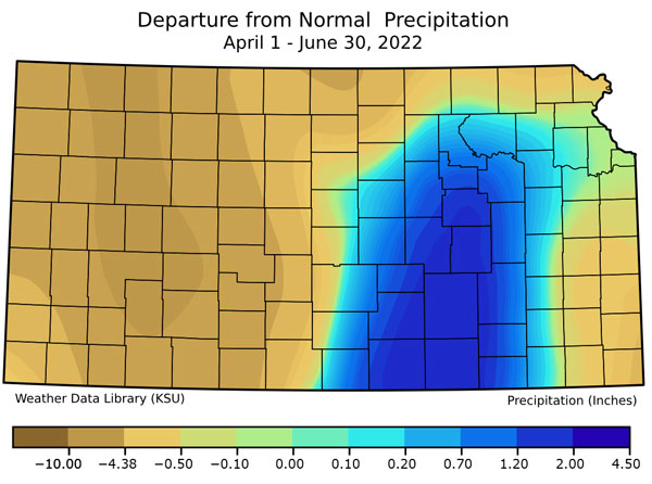
Figure 1. Departure from normal precipitation for Kansas from April 1 - June 30, 2022 from the National Weather Service, CoCoRaHS, and the Kansas Mesonet. Source: K-State Weather Data Library.
The drought has also played a role in the availability of fuel. Drought-stricken fuels have resulted in fires even before a freeze occurred. Due to these drought conditions, fuels that take longer to dry out including logs, timber lines, and grass thatch layers will hold more heat and burn effectively.
These are often sources of catching/slowing a fire down. Right now, they are additional areas that will burn hot and continue to carry fire. On a related suppression note, surface water availability has become limited due to the drought. Water supply may be a challenge for fire suppression.
Lastly, it will take a significant amount of rainfall/precipitation to offset the recent drought conditions. Without a substantial pattern change and weeks of moisture (remember, winter is the driest season of the year), drought will continue into the spring. Even with widespread precipitation, grasses and vegetation are dormant for the winter and can dry out very quickly. Grasses dry out in as little as an hour. Don’t let your guard down after a moisture event and be aware of wildfire concerns until spring green-up.
Ignition Sources
Most often, wildfires in Kansas start due to human causes such as escaped prescribed fire, welding, dragging chains, or parking in tall grass to name a few. In the summer of 2022 the state observed, at a minimum, 40+ lightning ignited wildfires. If these are all reported correctly, this drought year likely set a new record for the most natural started wildfires in a summer. Thankfully, as we move further into late fall and winter, thunderstorms become much less frequent. Lightning is less likely with climatologically low probability of natural ignitions. This means that most wildfires during the winter dormant season are preventable! People across the state need to be mindful of their activities and the potential for new fire starts from sparks, embers, and rekindles. Regardless of day-to-day weather, widespread drought and receptive fuels will be problematic for controlling wildfires until spring green up.
Weather Outlook
Last week’s eUpdate article went in depth on the fall/winter outlook. As a result of the forecast, combined with drought and above-normal fuel loading in the Flint Hills, concern for an above-normal fire season exists. While the weather pattern thus far in fall has been characterized by lighter winds than normal (Figure 2), early winter is typically a secondary peak in winds. Spring is considered the yearly peak (Figure 3) but both seasonal peaks occur in the typical dormant grass Kansas wildfire season. Unfortunately, with the short-term forecast into the next week or two, it appears winds are going to significantly increase across Kansas. With persistent dry conditions expected to prevail, this will greatly enhance fire weather concerns across the state.
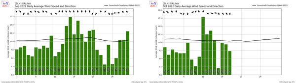
Figure 2. Wind speed compared to the September (left) and October (right) monthly normal (black line) at Salina Airport. Source: IEM Mesonet.
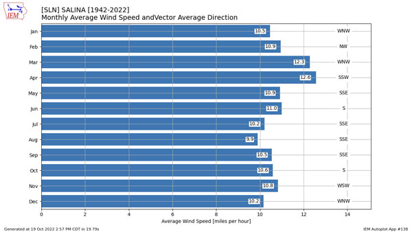
Figure 3. Average wind speed and direction by month for Salina Airport. Source: IEM Mesonet.
The longer term forecast is a bit more complicated. Unfortunately, there isn’t a good linkage between fire seasons and triple dip La Niña’s because of the rarity and lack of data reporting. However, with a similar pattern to last year, warm/dry conditions are definitely a concern. While last year was initially forecasted to trend towards more ENSO neutral conditions by the end of winter, it didn’t verify with the persisting La Niña. With the ENSO forecast again showing the neutral forecast by spring, this brings with it the same concerns as last year’s outlook.
A diminishing La Niña has been historically known to favor a more active spring. This provides a progressive jet stream with an increase in storm systems impacting the western US. While not an analog, it is good to reference the previous two triple dip La Niña’s end (2001 and 1976) and what occurred during March, often the main focus for Kansas fire season. Those two Marchs favored very different overall weather patterns across the United States. The March of 2021 (Figure 4, left) consisted of upper level low pressure in the eastern US favoring cooler conditions and non-conducive fire weather across the Plains. However, 1976 tells a story of a pattern extremely conducive with a prominent, strong upper level low across the western US. This is often a pattern that brings warm, dry strong winds from the southwest, resulting in large fire potential for Kansas.
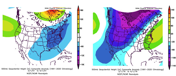
Figure 4. Upper level pattern for March 2021 (left) with blue representing low pressure, green/red high pressure in the upper levels (500mb). March 1976 on the left. Source: NOAA Physical Sciences Library.
The Climate Prediction Center (CPC) just released their new forecasts for the upcoming winter and beyond. These depict a very La Niña-type look to the pattern across the US for late winter focused on March (Figure 5). The equal chances of above/at/below normal temperature place Kansas on the gradient of colder to the north, warmer to the south. Additionally, the CPC favors below normal precipitation for most of the state, trailing from the far southwest US. This would favor the active storm track, more like the 1976 year, and the potential for increased wind events and conducive wildfire conditions across the state for the February through April timeframe.
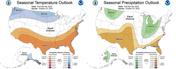
Figure 5. Seasonal temperature (left) and precipitation (right) outlooks for February 2023 through April 2023. Source: CPC.
The Bottom Line
There is a lot of variability in the weather component that is hard to forecast this far in advance. However, due to at/above fuel loading in the Flint Hills region, confidence there is increased for problematic and challenging fire behavior. Additionally, any wildfires there will be harder to suppress under more benign conditions. The Flint Hills is also characterized by continuous fuels with fewer barriers to spread than the remainder of the state. Elsewhere, less 2022 growth will result in reduced behavior, more conducive to suppression. Critical fire weather will be required to obtain extreme fire behavior in these regions. With these factors, above-normal fire activity seems very likely with persistence of winter La Niña weakening in the spring, resulting in an active storm track. When combined with antecedent drought conditions prevailing across the state, this sets the stage for a very long and challenging fire season. Any precipitation that does occur will not mitigate wildfire risk until spring green-up. Most of these fires will be human started. Let’s do all we can to avoid ignitions!
Christopher “Chip” Redmond, Assistant Meteorologist
christopherredmond@ksu.edu
Eric Ward, KFS Assistant Fire Management Officer
eward@ksu.edu
Shawna Hartman, KFS Public Information Officer
shartman@ksu.edu
Walt Fick, Extension Range Management
whfick@ksu.edu
Matthew Sittel, Assistant State Climatologist
msittel@ksu.edu
Tags: fire wildfire fire weather