Meteorological winter recently ended on February 28. In this report, we take a look at precipitation data across the state for winter 2022-2023.
For the 3-month period, Kansas averaged 2.91 inches for winter, slightly above the seasonal normal of 2.76 inches. December was drier than normal in all areas (Table 1). West central and southwest Kansas were the driest divisions, receiving just 0.12 inches of precipitation each. These amounts rank in the top 30 driest Decembers on record in those two divisions. January was wetter than normal in all divisions except for the southwest. The highest percentages were in northwest and west central Kansas in January, thanks to multiple winter storms which dropped generous amounts of snow. It was the 4th snowiest January on record in Goodland, where 16.5 inches of snow fell. February featured above-normal precipitation in eastern Kansas as well as northwest and west central Kansas, where snow was once again plentiful. When the three winter months are combined, six of the nine divisions had above-normal precipitation, with three divisions below normal. Eastern Kansas averaged from 4.5 to 5.0 inches of precipitation. There are some higher totals at individual locations in east central and southeast Kansas of 6.5 up to 7.3 inches of precipitation (Table 2). The wetter-than-normal conditions in the east led to 15% of Kansas being declared drought-free by the end of February (Source: US Drought Monitor). The composite Drought Severity Coverage Index (DSCI) fell from 345 at the end of November, 2022 to 311 at the end of February, 2023. Southwest Kansas, unfortunately, remains in a serious drought. February 2023 was the 17th consecutive month with below-normal precipitation in that division. Since October 2021, southwest Kansas’ total precipitation is just 13.33 inches, or 55% of the normal amount of 24.22 inches. As a result, 35% of the state remains in D4 drought status, the most severe category. This is almost four times larger than the next highest percentage of D4 for any US state (Oklahoma, 9%).
Table 1. Kansas precipitation totals by division for winter 2022-2023. Source: National Centers for Environmental Information. Above normal=green cells; below normal=orange cells.
|
Winter 2022-2023 Monthly Precipitation |
|||||
|
Climate Division |
December (% Normal) |
January (% Normal) |
February (% Normal) |
Winter (% Normal) |
Winter Rank |
|
Northwest |
0.48” (87%) |
0.90” |
0.63” (115%) |
2.01” (133%) |
21st Wettest |
|
North Central |
0.63” (68%) |
1.08” (169%) |
0.72” (85%) |
2.43” (100%) |
49th Wettest |
|
Northeast |
0.82” (63%) |
1.55” (196%) |
2.22” |
4.59” (141%) |
20th Wettest |
|
West Central |
0.12” (21%) |
1.01” (235%) |
0.71” (125%) |
1.84” (116%) |
34th Wettest |
|
Central |
0.66” (62%) |
0.99” (139%) |
0.79” (78%) |
2.44” (88%) |
53rd Wettest |
|
East Central |
1.17” (77%) |
1.52” (157%) |
2.26” (159%) |
4.95” (127%) |
24th Wettest |
|
Southwest |
0.12” (16%) |
0.47” (96%) |
0.37” (74%) |
0.96” (56%) |
44th Driest |
|
South Central |
0.87” (76%) |
0.94” (119%) |
0.84” (77%) |
2.65” |
55th Wettest |
|
Southeast |
1.68” (95%) |
1.37” (112%) |
1.95” |
5.00” |
39th Wettest |
|
STATE |
0.73” (68%) |
1.06” (147%) |
1.12” (115%) |
2.91” (105%) |
40th Wettest |
Table 2. Highest winter precipitation totals across Kansas. Source: SC-ACIS.
|
Location |
County |
Network |
Amount |
|
Fredonia |
Wilson |
COOP |
7.32” |
|
Parsons 0.8 SE |
Labette |
CoCoRaHS |
7.22” |
|
Oswego 1 N |
Labette |
COOP |
7.20” |
|
Ottawa |
Franklin |
COOP |
6.96” |
|
Garnett 1 E |
Anderson |
COOP |
6.92” |
|
Columbus |
Cherokee |
COOP |
6.88” |
|
Bartlett |
Labette |
COOP |
6.77” |
The predominant storm track this winter was one that brought snowfall to northwest Kansas as well as areas along the Kansas-Nebraska border, with rainfall for eastern Kansas. As a result, northwest Kansas is the only area with above-normal snowfall for the six-month period ending February 28, 2023 (Figure 1). Goodland’s 35.5 inches is around 14 inches above normal, and ranks as their 10th snowiest, fall and winter combined, on record. Meanwhile, Manhattan’s 3.3 inches ranks as the 6th least snowfall, and Topeka’s 5.8 inches ranks just outside the top 10 least snowy. Much of the snowfall in the northwest was unable to soak into the ground as it melted, as 4-inch soil temperatures were below freezing for weeks, after a bitter cold spell just before Christmas dropped air temperatures to as low as -19°F. Thus, improvements to drought conditions were not as widespread as the above-normal precipitation amounts would suggest.
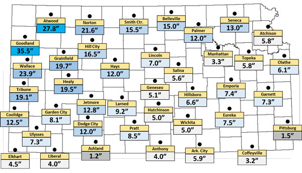
Figure 1. Total snowfall for select Kansas locations from September 1, 2022 through February 28, 2023. Source: SC-ACIS.
Spring precipitation outlook for Kansas
Will 2023 end up being one of the wetter years on record? Eastern Kansas seems to be off to a good start. As we look into spring, the current outlook for March through May shows equal chances of above, below and near normal precipitation for Kansas (Figure 2). There is no clear indication from this map that a wet winter will lead to a wet spring as well, but we can certainly hope for improvement, particularly in the southwest.
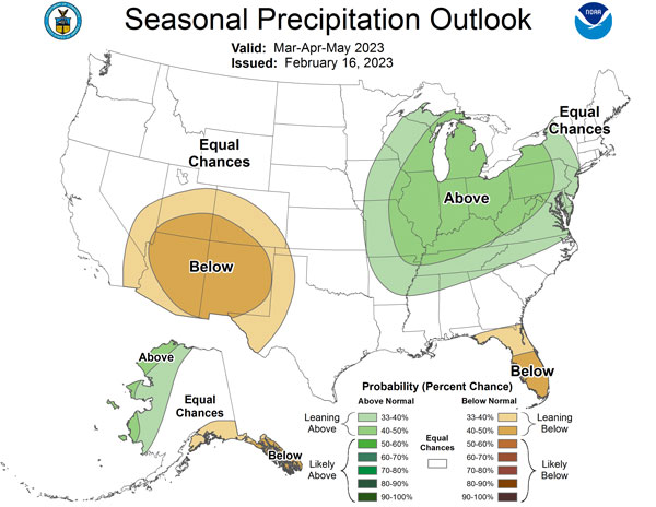
Figure 2. Meteorological spring precipitation outlook. Source: Climate Prediction Center.
Matthew Sittel, Assistant State Climatologist
msittel@ksu.edu