A white Christmas, by meteorological definition, occurs if there is at least 1 inch of snow on the ground on Christmas morning, December 25, at 7 AM local time. The National Centers for Environmental Information (NCEI) has produced an official map with the probabilities of a white Christmas across the lower 48 states. The map is based on 30-year climatological normals updated by NCEI every 10 years. The most recent edition is based on data for the latest set of normals, spanning 1991-2020 (Figure 1).
There are only a few areas of the country where a white Christmas is a near certainty: northern Minnesota, northern New England, and the highest terrain of the western United States, such as the Rockies, the Sierra Nevadas, and the Cascades. There is a very low chance of a white Christmas for the southeastern states, including Florida and along the Gulf Coast. Probabilities are also very low for Texas, the desert southwest, and the west coast. For all other locations, the chances fall between impossible and certain, such as in the central states.
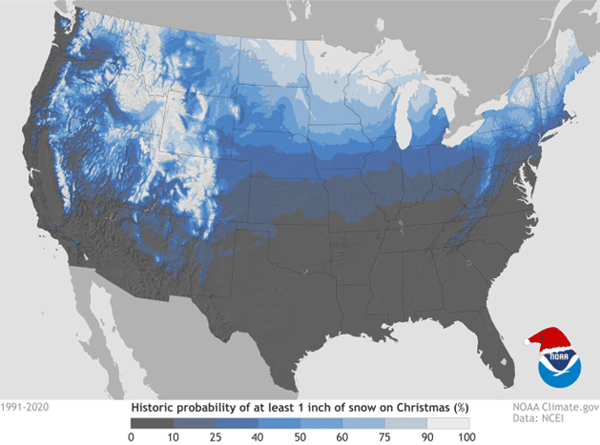
Figure 1. The probability of a white Christmas across the lower 48 states. Source: noaaclimate.gov
In Kansas, the probabilities are highest in the north along the Nebraska border and lowest in the southeast. The highest probability in the state is in Mankato, in Jewell County, with a 33% chance of a white Christmas. Table 1 lists the probabilities of a white Christmas at selected locations around Kansas. The table also includes information such as the most recent white Christmas, average December snowfall, and average and recorded temperatures for Christmas Day.
Table 1. White Christmas probabilities, most recent white Christmas, average snowfall, and record temperatures for selected Kansas locations.
|
City |
White Christmas Probability (1991-2020) |
Most recent (inches) |
Deepest Dec. 25 snow (year) |
Avg. Dec. snow |
Average High/Low Dec. 25 |
Record High/Low (year) |
|
Manhattan |
22% |
2022 (1”) |
7” (2013) |
4.8 |
41° / 20° |
70° (1889) -13° (1983) |
|
Topeka |
18% |
2022 (1”) |
6” (1983) |
4.1 |
41° / 22° |
68° (1922,2016) -11° (1983) |
|
Wichita |
12% |
2022 (2”) |
4” (1962, 2007) |
3.1 |
44° / 24° |
68° (2019) -6° (1983) |
|
Dodge City |
17% |
2013 (3”) |
12” (1997) |
4.0 |
44° / 21° |
74° (1950) -13° (1879) |
|
Goodland |
22% |
2022 (3”) |
13” (1941) |
5.2 |
43° / 17° |
74° (1950) -9° (2012) |
|
Hays |
21% |
2011 (7”) |
11” (1945) |
3.3 |
42° / 17° |
73° (1955) -11° (1983) |
|
Concordia |
23% |
2017 (1”) |
10” (1983) |
4.5 |
39° / 20° |
64° (2016) -8° (1983) |
The most recent white Christmas in parts of Kansas was last year. A bitterly cold air mass arrived in Kansas on the 21st, sweeping the entire state. By the morning of the 22nd, temperatures were as cold as -19°F in Cheyenne County. Some snow accompanied the Arctic air, and for areas where measurable snow was received, it stayed put for a few days as temperatures were slow to moderate. Places like Goodland, Manhattan, and Topeka all had a white Christmas, with 1 to 2 inches of snow on the ground on Christmas morning. Bitter cold temperatures were also the rule that morning, with lows as cold as -7°F at Baldwin City in Douglas County.
Could we have an encore performance this year? Unfortunately, it doesn’t look as promising as last year at this time. The current outlook for the week leading up to Christmas morning has high probabilities of above-normal temperatures statewide (Figure 2). There are slightly elevated chances of above-normal precipitation for the entire state (Figure 3), but with above-normal temperatures expected, it’s more likely that if we get precipitation during this time frame, it will fall as rain rather than snow.
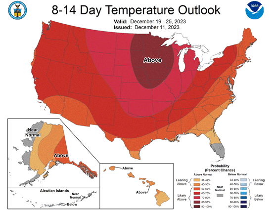
Figure 2. The Climate Prediction Center’s 8 to 14-day temperature outlook for December 19-25, 2023.
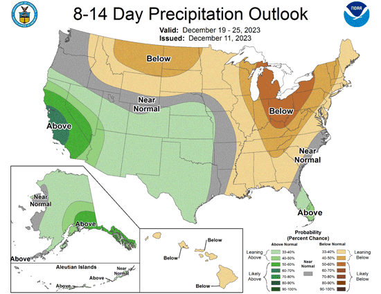
Figure 3. The Climate Prediction Center’s 8 to 14-day precipitation outlook for December 19-25, 2023.
The forecast could change between now and Christmas Day, but a white Christmas looks unlikely for now. While a disappointment for some, above-normal temperatures and no snow would be welcome for those with travel plans before Christmas. Have a happy and safe holiday season!
Matthew Sittel, Assistant State Climatologist
msittel@ksu.edu