Spring has sprung across Kansas! Temperatures are warming, and so has the soil. Let’s take a closer look at where things stand through the first half of April.
The changing of the calendar from March to April coincided with a change in temperatures across the Sunflower State. The average temperature in March across Kansas was 42.2°F or 2.6° below normal. All nine climate divisions averaged below normal last month; departures ranged from -4.9°F in the northwest to -1.5°F in the southeast. The average temperature for the first half of April is 55.7°F or 4.6° above normal. All divisions are above normal, with departures ranging from +3.5° (southeast) to +5.6° (north central). As a result, soil temperatures, which lagged behind seasonal normals for the last three weeks of March, are now well above normal. As of April 16, the 7-day average 2-inch soil temperature across Kansas is 60.0°F, a full six degrees above normal (Figure 1). April 12 and 13 were the warmest days so far this year; the average high and low temperature across the Kansas Mesonet for both days were 86°F and 53°F respectively, well above the normal values for those dates of 66°F and 39°F. Highs in the 90s were common across western Kansas, with widespread 80s across the east. We can thank these warm readings for the recent rapid increase in soil temperatures.
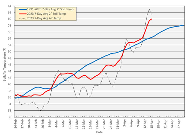
Figure 1. 30-Year average 2-inch soil temperature, 2023 average 2-inch soil temperature, and 2023 average air temperature. Average data plotted are 7-day values. Dates plotted represent the last day of the 7-day average period. Source: Kansas Weather Data Library.
Temperatures this time of year are quite variable though, so 90s in April doesn’t mean summer has come early and is here to stay. This past weekend brought a reality check: colder weather. The mornings of April 16 and 17 were chilly, with below-freezing temperatures recorded in many areas. There was even a trace of snow reported in Goodland. This has resulted in cooler soil temperatures, which in turn has halted the increase of the 7-day average. These rapid switches from one extreme to the other are common this time of year. The 30-year average soil temperature line is much smoother than the 2023’s line because the warm and cool periods in any given year average out when added to all the other years. We shouldn’t expect 2023, or any other year, to mirror the gentle increase of the average line. But now that we’re into the second half of April, it’s very unlikely that average soil temperatures will tumble back down to below 50°F, which is good news for those who use that threshold to determine when to plant crops.
Growing degree day accumulation
Speaking of thresholds, an additional measure of the ground’s readiness for planting is growing degree days (GDDs). Given the switch to warmer weather in April, are the accumulated growing degree days for 2023 above or below normal? Table 1 contains the number of corn GDDs at a few select locations around Kansas. The low and high thresholds for corn GDDs are 50° and 86°F, respectively. The high temperature must reach at least 50°F to accumulate corn GDDs on any given day, and the warmer the average temperature is that day, the more GDDs there are. This year’s accumulated corn GDDs are above normal at all locations, even in northwest Kansas where snow was plentiful and temperatures were often the coldest in the state during winter. At four locations, the total GDDs are above 400, historically considered one threshold for the ground’s readiness to plant corn. As spring continues and temperatures warm, the average number of GDDs accrued each day increases, so the totals will increase faster in the coming weeks and all locations should be above 400 by month’s end.
Table 1. Accumulated corn growing degree days at select Kansas sites through April 15 compared with 1991-2020 normals. 2023 GDDs are taken from the nearest Mesonet site to the listed locations, while 30-year normals are derived from NCEI normal temperatures.
|
Location |
2023 YTD |
Normal YTD |
Difference |
Average Daily Corn GDDs |
||
|
Apr 15 |
May 1 |
May 15 |
||||
|
Ashland |
620 |
437 |
+183 |
11 |
13 |
17 |
|
Belleville |
288 |
237 |
+51 |
8 |
10 |
14 |
|
Garden City |
414 |
358 |
+56 |
9 |
12 |
15 |
|
Goodland |
308 |
272 |
+36 |
7 |
9 |
13 |
|
Hays |
360 |
315 |
+45 |
9 |
11 |
15 |
|
Hutchinson |
427 |
311 |
+116 |
9 |
11 |
15 |
|
Manhattan |
362 |
291 |
+71 |
8 |
11 |
15 |
|
Olathe |
389 |
280 |
+109 |
9 |
12 |
15 |
|
Parsons |
446 |
332 |
+114 |
10 |
12 |
15 |
Soil moisture status
One important variable for a successful start to the growing season that is missing from some locations is adequate moisture. Year-to-date precipitation as of April 15 is below normal in all of Kansas’ nine climate divisions (Table 2). Statewide, the average precipitation is 3.18 inches or 64% of normal. Northeast Kansas is closest to normal (5.60 inches or 95% of normal), with east central Kansas close behind (6.28 inches or 94% of normal). Southwest Kansas is the driest division (0.99 inches or 32% of normal).
Table 2. Year-to-date precipitation totals and percentages of normal for the state and each of Kansas’ nine climate divisions, as of April 15.
|
|
Year-to-date (Jan 1-Apr 15) |
||
|
Average Precip. (inches) |
Departure (inches) |
% Normal |
|
|
Northwest |
2.48 |
-0.75 |
77% |
|
North Central |
2.63 |
-2.11 |
55% |
|
Southwest |
5.60 |
-0.28 |
95% |
|
West Central |
2.02 |
-1.24 |
62% |
|
Central |
2.78 |
-2.30 |
55% |
|
East Central |
6.28 |
-0.37 |
94% |
|
Southwest |
0.99 |
-2.11 |
32% |
|
South Central |
2.36 |
-3.08 |
43% |
|
Southeast |
4.87 |
-2.67 |
65% |
|
STATE |
3.18 |
-1.79 |
64% |
Weather outlooks
Temperatures will continue to warm during the spring, but will undoubtedly vary from week to week. In the short term, another round of cooler air this coming weekend could bring freezing temperatures to parts of Kansas, just as we had this past weekend. The 8 to 14-day temperature forecast issued on April 16 (Figure 2) says there are slightly higher than normal chances for above-normal temperatures for the last week of April, so a freeze this weekend is not currently expected to usher in an extended period of below normal temperatures. The 8 to 14-day precipitation outlook for the same period (Figure 3) has equal chances of above, below, and near-normal precipitation for much of the state. There are slightly elevated chances of above-normal precipitation in the southeast and below-normal precipitation in the far west. At this stage, we need the whole state to be covered in shades of green, indicating above-normal chances for precipitation to erase the growing precipitation deficits in the drought-stricken areas of Kansas. As of now, it doesn’t appear that relief in these areas is imminent.
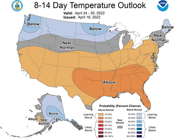
Figure 2. Climate Prediction Center’s 8 to 14-day temperature outlook.
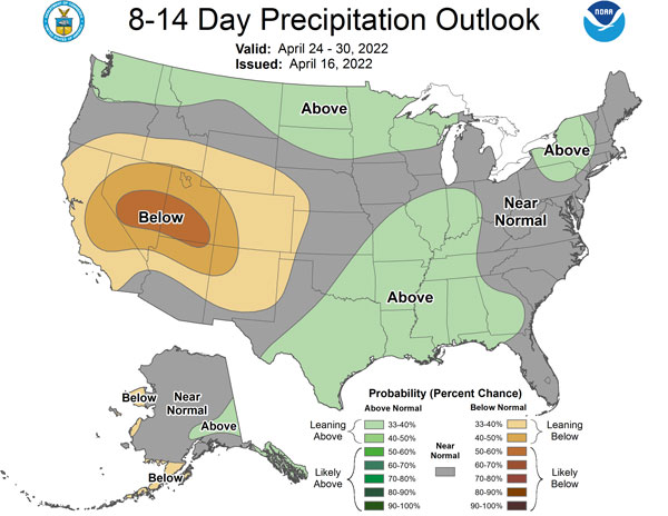
Figure 3. Climate Prediction Center’s 8 to 14-day precipitation outlook.
Matthew Sittel, Assistant State Climatologist
msittel@ksu.edu
Tags: Drought soil moisture spring planting soil temperature growing degree days