Precipitation summary
For the week ending on December 1, 2020, statewide precipitation averaged 0.56 inches, 206 percent of normal. The heaviest precipitation was centered in the Northeast, but trailed to the southwest. (Figure 1). The highest precipitation total reported for the week was 2.71 inches at Fostoria 7NW, Pottawatomie County. Not surprisingly, with additional amounts above an inch, the Northeast Division is the wettest for the week with an average of 1.37 inches, 391 percent of normal (Figure 2). The Northwest Division was the driest with a divisional average of zero. The West Central Division also missed out on most of the precipitation, with a divisional average of 0.05 inches, 38 percent of normal.
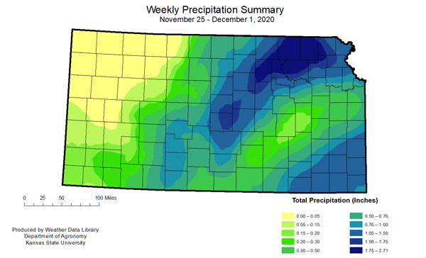
Figure 1. Total precipitation (inches) recorded for the week of November 25 – December 1, 2020. Map by the Kansas Weather Data Library.
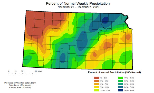
Figure 2. Percent of normal precipitation for the week of November 25-December 1, 2020. Values less than 100 indicate below normal amounts. Map by the Kansas Weather Data Library.
Temperature summary
The week averaged slightly warmer than normal temperatures. There was a 61 °F temperature swing during the period with the highest reading 64°F reported at Atwood, Rawlins County, on Nov. 29 and Coffeyville Airport, Coffey County, on the 27th. The coldest temperature reported was 3°F at Oakley 4W, Logan County, on the 30th. The statewide temperature averaged 37.0 °F for the week, 0.9 degrees warmer than normal (Figure 3). The North Central Division was the warmest with an average of 36.6 °F, 2.7 degrees warmer than normal. The West Central Division was the coolest at 33.6 °F, 0.7 degrees cooler than normal.
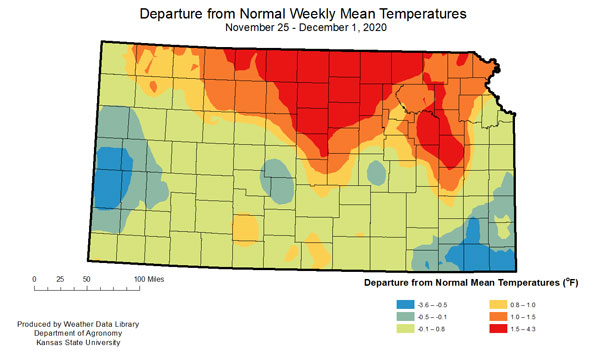
Figure 3. Departure from normal weekly mean temperatures for week of November 25 – December 1, 2020.
Change in drought status for Kansas
Given the widespread precipitation, there was a shift of drought coverage in the Drought Monitor. There was improvement in the North Central, Central and Northeast divisions with decreases in moderate and severe coverage (Figure 4 and Figure 5). There was a small reduction in abnormally dry conditions in the Southeast and South Central divisions where some of the greatest precipitation totals were reported. The Southwest Division saw some expansion of the severe and extreme drought categories. Lighter winds than the previous week, coupled with temperatures closer to normal, resulted in near-average water demand across the state during the period (Figure 6).
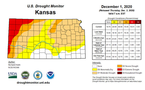
Figure 4. Current weekly drought status (U.S. Drought Monitor).
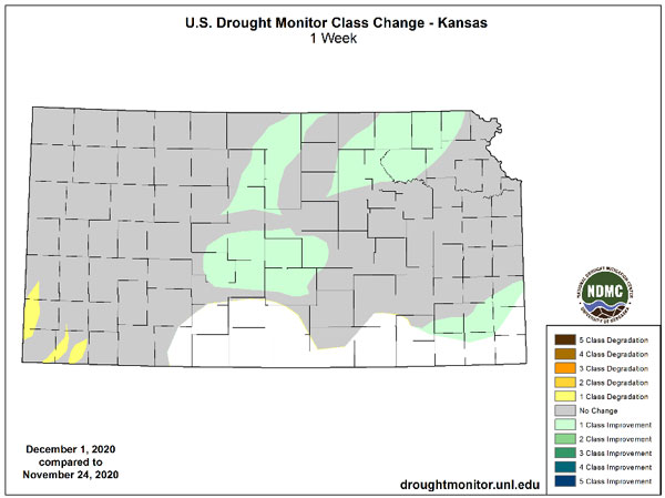
Figure 5. Change in weekly drought status (U.S. Drought Monitor).
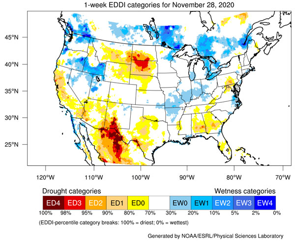
Figure 6. Evaporative Drought Demand Index factoring evaporative demand in respect to wind and moisture availability (NOAA, https://psl.noaa.gov/eddi/).
Looking ahead in December
In the upcoming week, moisture will be limited (Figure 7), with measurable precipitation expected only in the southeast part of the state. Most of this is likely to occur in the first part of the period, as the current winter storm pulls eastward. Moisture from this system, which came after the Tuesday cut-off period, will be included in the drought analysis for next week. A return to drier/warmer weather is expected beyond next week with a chance of below-normal precipitation and above-normal temperatures statewide (Figure 8). As we move into December, average precipitation across the west continues to decrease, while remaining steady in the east. Outlooks for the entire month of December favor above normal temperatures and below normal precipitation statewide (Figure 9).
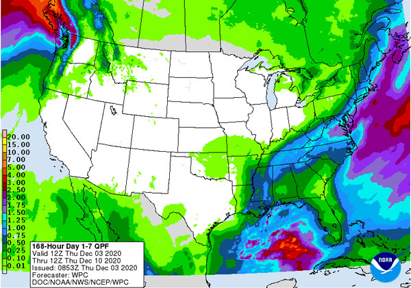
Figure 7. Quantitative precipitation forecast for week ending on 12/10/2020 (Weather Prediction Center).
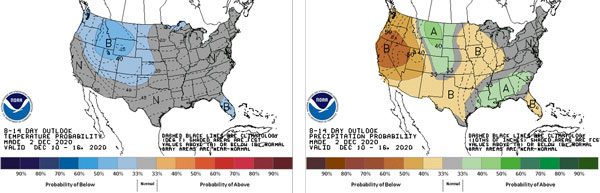
Figure 8. 8 to14 day temperature and precipitation probability outlooks for 12/10 – 12/16 (Climate Prediction Center).
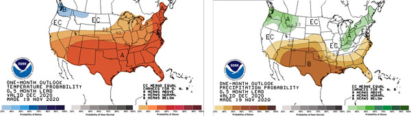
Figure 9. Temperature and precipitation outlooks for December 2020 (Climate Prediction Center).
More details in upcoming webinar
The Kansas Water Office is hosting an informational webinar on Monday, December 7, 2020. This webinar will provide more details on the current drought situation, as well as an updated outlook for the coming months. You can access the webinar details and register here: https://fb.me/e/1X3ZUafzA
Summary
- Heavy precipitation bisects the state
- Near-normal temperatures statewide.
- Some reduction in drought for areas with heaviest precipitation
- Limited precipitation for the week of Dec. 3 –Dec. 10
Mary Knapp, Assistant State Climatologist
mknapp@ksu.edu
Christopher “Chip” Redmond, Kansas Mesonet Manager
christopherredmond@k-state.edu