The start of 2023 has been quiet wildfire-wise across Kansas. Much of central and eastern Kansas received above-normal moisture in January (https://bit.ly/3l7QjTx), helping keep fires at bay despite much above-normal temperatures.. As we approach the core part of Kansas fire season, March and April, this trend may not remain the same.
Background conditions conducive for large fires in Flint Hills
While last year only had slightly above normal large fire activity, overall fires through the year were substantially increased due to drought. Most remained small and were handled locally with no issues. Our concern is the potential for large wildfires that are extremely impactful and disruptive. One reason Kansas had numerous smaller fires was because of persistent availability to burn. Many portions of western Kansas never “greened up” or observed active spring/summer grass growth due to dry conditions. These areas saw continuous fire activity in 2022. However, they also have less grass/fuel to burn this year and, under critical fire weather conditions, can be controlled more easily (Figure 1). Further east into the Flint Hills, precipitation during the peak grass growing months of April to June was above normal by several inches. Therefore, fuel loading in this region is at or above normal and the concern is higher for aggressive fire behavior under even moderated conditions. We saw this in the fall with multiple large wildfires occurring in the Marion and Butler County region.
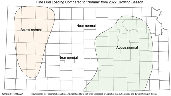
Figure 1. Areas of estimated above/below/at normal grass (or fuel) loading. Above normal areas observed increased moisture during the growing season and have potentially more potential for increased fire behavior and large fire potential. The opposite is expected in the below normal area. Estimates from numerous sources were also considered. Source: Kansas Forest Service.
Weather patterns play a role
Contrary to popular belief, large wildfires in Kansas are usually independent of long term drought conditions. Short term weather drives fire potential in the state and determines availability of grass to burn. This makes predicting a fire season challenging because one or two conducive days can skew an entire season. We see similar challenges to seasonal tornado predictions in Kansas.
There are several weather events that are responsible for the biggest wildfires in Kansas history. The most dangerous is what meteorologists call a “mid-latitude cyclone”, a low pressure system that typically forms east of the Rocky Mountains and moves eastward across the Plains. These dynamic systems typically feature strong winds and drastic air masses separated by fronts as they spin counter clockwise around the center. Systems of this nature provide significant challenges with shifting winds that make firefighting dangerous and fire spread nearly impossible to suppress.
Mid-latitude cyclones are also often responsible for severe weather and even blizzards - all dependent on your location to the center of the low. The area between the dryline and cold front are most conducive for wildfires. Historical fires such as Four Corners, Starbuck, and Anderson Creek all developed in the shaded orange area of a low pressure system (Figure 2).
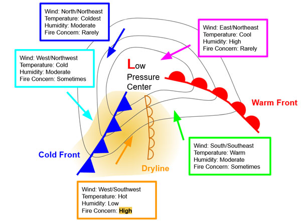
Figure 2. Diagram depicting a surface low pressure system responsible for the most active weather on the Plains. Significant wildfires may develop south of the center of the low pressure between the dryline and the cold front.
Strong low pressure systems are usually well forecasted at most one to two weeks in advance. Beyond that, we must look at whether upcoming patterns are favorable for such systems. La Niña remains the main contributor in the extended forecast despite showing signs of weakening. It is important to note that despite persistent La Niña the last three winters, the outcomes of each spring have been very different. January 2023 was a great example with an active “atmospheric river” event providing significant moisture to the southwest, Rockies, and central Plains. This pattern persisted for several weeks and provided very different conditions than a typical La Niña. Results of this anomalous pattern will likely drive future local influences, potentially dominating the overarching oceanic oscillations.
Looking to the future
Thus far in February, overall temperatures have continued the theme of above normal for a majority of the state. While there is a brief period of cooler-than-normal temperatures expected to start March, the Climate Prediction Center (CPC) is calling for equal chances of at/below/above normal temperatures for Kansas for the month. Additionally, the CPC calls for a similar scenario for precipitation and carries these equal chances through the three-month spring period of March - April - May.
Currently, an active pattern is set to continue with one to two storm systems a week favored across the central US. This will be enhanced somewhat by the still persistent impacts of La Niña and amplified by the results of the recent pattern. Therefore, it appears likely that those that have received moisture will likely continue to see precipitation. This doesn’t favor the central/western portion of the state that will remain mostly dry, even though this area recently received some snow.
As spring progresses, we can expect storm systems to bring wilder weather and stronger winds. Typically, weakening La Niña’s can result in even more active spring weather. This has been found to both increase hail and tornado occurrences in the eastern part of the state. These low pressures, as mentioned earlier, also favor an increase in fire weather conditions west of the storms, potentially in central and west Kansas. These regions are likely to observe an increase in fire activity as a result. Some of the drier conditions exist in the western Flint Hills where there is increased fuel loading. Potential in this area is highest for large fires this spring before green up. Large wildfires could still occur further west, however, weather conditions would have to be rather extreme and/or a fire would have to start in a location with locally higher fuel load for large fire potential.
Shrinking the 2023 wildfire potential window
The conclusion of fire season is typically considered if/when grasses green up across the state. This varies by year and is mostly dependent on soil moisture and temperatures. Thus far in 2023, green up nationally is moving northward at record pace and arriving up to a month early (Figure 3). With the current projection of temperatures, it is expected to continue. However, once it reaches the current drought center point in Kansas (Figure 4) and its respective dry soil profiles, green up should slow.
Elsewhere, especially in the eastern part of the state, moisture surpluses will likely bring a quick green up and end to wildfire season. Fires will still be possible; however, for a limited period of time. Additional challenges such as mud will complicate fire suppression. Early green up could also increase potential for late frost/freezes which may damage grasses and make them able to burn later in spring.
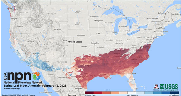
Figure 3. National Phenology Network Spring Leaf Index Anomaly as of February 16, 2023. Red areas represent where green up is occurring up to a month early.
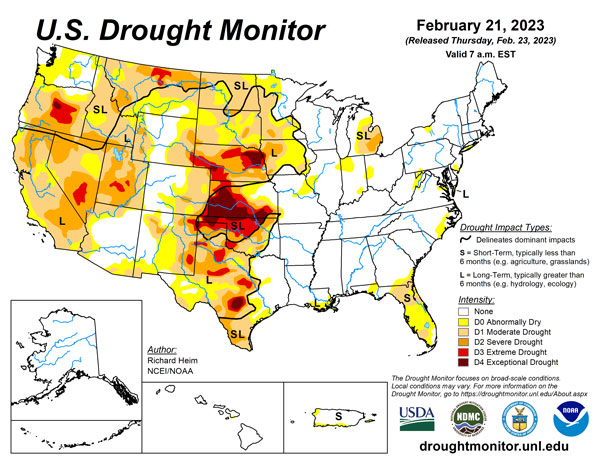
Figure 4. United States Drought Monitor as off February 21, 2023. Kansas is the center of the worst drought conditions in the country currently.
Preparing for wildfires
Most fires in Kansas are caused by human activity. Debris burning, escaped prescribed burn, welding or cutting in dry grass, dragging chains, and defective equipment are examples of human-induced fires. Be especially cautious on any dry, breezy day – which is pretty common during spring in Kansas before green up.
Take steps to prepare your property to survive a fire. Clearing brush from the house, keeping gutters cleaned out, having non-combustible siding and roofing material, and more. In a major wildfire, the fire department will simply not have enough resources to protect every home or property, so those that can survive on their own have the best chance. For more information, please refer to KSRE publication MF2241 Protecting your home from wildfire at https://bookstore.ksre.ksu.edu/pubs/MF2241.pdf
More information on how to have a successful and safe prescribed burn will be available in an upcoming eUpdate.
The bottom line
Conditions into spring will become increasingly conducive for wildfires in the western Flint Hills and central/western Kansas. Overall, fire season is expected to be at/near average for the March through April timeframe. Wildfires are a real risk for Kansas even with recent moisture. People should have a plan and take proper precautions to avoid fire starts and limit fire spread.
Christopher “Chip” Redmond, Kansas Mesonet
christopherredmond@ksu.edu
Eric Ward, Assistant Fire Management Officer – Kansas Forest Service
eward@ksu.edu