The Kansas Ag-Climate Update is a joint effort between our climate and extension specialists. Every month the update includes a brief summary of that month, agronomic impacts, relevant maps and graphs, 1-month temperature and precipitation outlooks, monthly extremes, and notable highlights.
October 2021: A precipitation dipole but warm planting dates for winter wheat
Statewide average temperature for the month was 59 oF, which is 2.8 oF warmer than normal, the 24th warmest October during the past 127 years. This month was the warmest October since 2016, following three consecutive below average Octobers from 2018 to 2020 (Figure 1). A higher temperature departure from normal was observed in eastern Kansas. There were 84 record high daytime temperatures and 9 record high nighttime temperatures observed, mostly in eastern Kansas.
Precipitation amount was slightly wetter on average (27th wettest month in 127 wet rankings), however, there was a dipolar distribution across Kansas. The eastern regions, especially in the southest, were quite wet at +2.6 inches above normal, which contrasts with western Kansas being dry at 0.6 inches below normal. Statewide average precipitation for the month was 3.2 inches, about 1 inch wetter than normal.
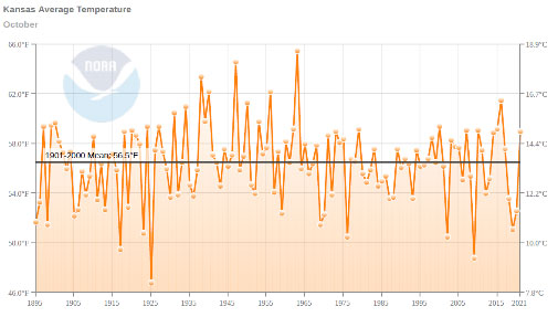
Figure 1. Long-term average temperature during October for Kansas. Source: NOAA
View the entire October Ag-Climate Update, including the accompanying maps and graphics (not shown in this short article), at http://climate.k-state.edu/ag/updates/.