The Kansas Ag-Climate Update is a joint effort between our climate and extension specialists. Every month the update includes a brief summary of that month, agronomic impacts, relevant maps and graphs, 1-month temperature and precipitation outlooks, monthly extremes, and notable highlights.
November 2020: Warming winter season started with a band of heavy precipitation
November was on the dry side of the distribution for precipitation. It ranked as the 72nd driest November since 1895. There was a significant split in moisture across the state. Statewide average precipitation for the month was 1.23 inches, 88 percent of normal (Figure 1). The Northwest Division was the driest, with an average of 0.05 inches, 6 percent of normal. In contrast, the Northeast Division averaged the most precipitation, at 2.48 inches, 142 percent of normal.
Temperatures were above normal (Figure 1). The statewide average for November was 5.3 degrees warmer than normal. The thermal heat unit was driven by warm minimum temperatures. There were 52 daily record high maximum temperatures and 126 daily record warm minimum temperatures.
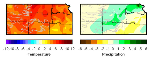
Figure 1. Departures from normal temperature (°F) and precipitation (inches).
View the entire November Ag-Climate Summary, including the accompanying maps and graphics (not shown in this summary), at http://climate.k-state.edu/ag/updates/.