The Kansas Ag-Climate Update is a joint effort between our climate and extension specialists. Every month the update includes a brief summary of that month, agronomic impacts, relevant maps and graphs, 1-month temperature and precipitation outlooks, monthly extremes, and notable highlights.
March 2022: Near-normal temperatures statewide with water supply pumped up in the east
Statewide average temperature in March was closer to the normal, with an average temperature of 43oF across the state. This was only about -0.5oF cooler on average than normal (Fig. 1). The temperature ranked as the 77th coldest and 52th warmest month of March during the past 128 years. However, considering the 5-month window for winter wheat growth, the average recent 5-month ( November to March) temperature is ranked as the 14th warmest since 1895.
Climatologically, Kansas March precipitation was about 2 inches. This month was slightly drier in the west but significant wetter across the eastern portion of the state (1.1” above the normal) (Fig. 1). It ranked as the 29th wettest March during the past 128 years. Similarly, considering the 5-month accumulated precipitation for winter wheat growth, it was less than 1.9 inch drier than the 5-month normal with a marked east-west gradient (Fig. 2). This 5-month precipitation was still the driest since 2018, which has the potential to decrease wheat grain yields.
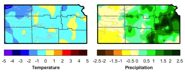
Figure 1. Departures from normal temperature (°F) and precipitation (inches) for March 2022.
View the entire March 2022 Ag-Climate Update, including the accompanying maps and graphics (not shown in this short summary), at http://climate.k-state.edu/ag/updates/