After a relatively cool start to July, things are expected to change in early August. Excessive heat is forecasted by the National Weather Service (Figure 1) beginning this weekend, with high likelihood it will continue into early next month. While warm temperatures are expected in the summer, the combination of warmer overnight low temperatures and humid conditions can quickly accumulate on people and develop heat stress.
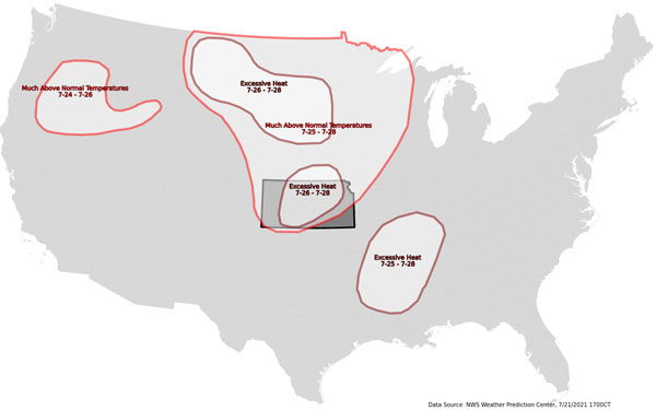
Figure 1. Hazard map for July 24-28, 2021 using the National Weather Service Weather Prediction Center data with focus on Kansas.
Though much of the state did observe a warm period in mid-June, we were lucky enough to not have high humidity. As a result, temperatures felt cooler than they actually were. For the upcoming week (and likely longer), afternoon dew points are forecasted to remain above 60°F and reach as high as 70-75°F (lower in the west). This will yield much higher humidity than the 15-30% observed in June. In addition, higher moisture content in the air prevents overnight low temperatures from dropping much, as lows won’t drop below the dew point. These warmer lows prevent the body from recovering and can rapidly increase heat stress for those without air conditioning.
The science behind the heat
Recent record-setting heat in the northwest US has many wondering if this period of above-normal temperatures is related. The answer is yes and no. That extremely strong high pressure broke down with the storm system that provided rain to much of Kansas a week ago. As a result, the accumulated heat has been modified significantly (hence why we aren’t seeing additional 110°F+ readings. Since then, the focus of the high pressure and its associated air (blue H in Figure 2 and impacts of heat outlined in red) have moved eastward into the central US. The ridge of high pressure is of similar origins, just much cooler air than what was observed in the northwest. Secondly, the once-absent “monsoon season” in the southwest has now appeared with a large broad low pressure (red L in Figure 2 with impacts highlighted in an orange circle). This has helped the ridge remain in place with a stagnant upper level flow. Moisture continues to feed this area from both the Gulf of Mexico (and origins southwest). Any time you see reasonable upper level flow from east to west as occurring to our south, flow is likely stagnant and big weather pattern changes aren’t likely in the near future. The only way this pattern would change is if a strong hurricane can impact the flow, either in the Atlantic or Pacific, which is possible mid-August. Otherwise, the doldrums of summer are in full swing.
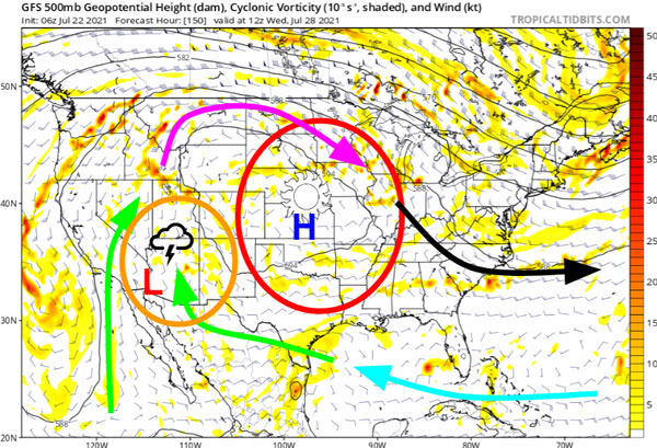
Figure 2. Upper level winds forecasted for next week (mid-week). Easterly flow is represented by the blue arrow. Green arrows represent moisture flow into the southwest “monsoons.” Purple arrow signifies the overall weak storm track taking occasional moisture to our north. Black is stronger flow to the east associated with increased storminess and cooler weather. Area of high pressure (H) is highlighted in red with broad low pressure (L) highlighted in orange. Image source: tropicaltidbits.com with annotations by author.
Be prepared
In advance of this heat, it is recommended that you begin to prepare now. Some simple ways to counteract these oppressive temperatures and humidity include:
- Check your air conditioning and ensure it is operating properly.
- Reschedule plans of outdoor work/activity in advance to limit exposure during peak afternoon hours.
- Check on your neighbors and sensitive groups (such as expectant mothers, elderly, or children), ensuring they are prepared.
- Increase water intake. Thorough hydration begins days before outdoor activities.
- Locate areas of shelter should you need to cool off.
- Familiarize yourself with the symptoms of heat illness.
For additional information, visit https://www.weather.gov/wrn/summer-heat-sm for more graphics and tips!
To monitor current heat indices, visit the Mesonet at: http://mesonet.k-state.edu/weather/heat/

Mary Knapp, Assistant State Climatologist
mknapp@ksu.edu
Christopher "Chip" Redmond, Kansas Mesonet Manager
christopherredmond@ksu.edu