Spring wildfire season in Kansas can be highly variable and depends on residual impacts from the previous growing season and often short duration weather events. While prolonged drought and climate conditions impact the availability of fuels, wind events and dry periods several months out are impossible to predict. However, using specific global circulations, trends, and previous weather, we can approximate the expected fire conditions next spring.
2020 Spring fire weather summary
Winter precipitation was above normal most of Kansas last year. Combined with warmer than normal temperatures, this led to an earlier than normal spring green up across the region. Fortunately, this saved Kansas from seeing an above normal fire season as the months following green up were quite dry (Figure 1). As a result, a relatively quiet fire season occurred. Fire reports increased early summer as a result of such a dry late spring but quickly receded in July with above normal precipitation for all but the far west.
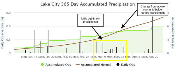
Figure 1. Timely precipitation to avoid heightened fire weather while trending below normal at Lake City (mesonet.ksu.edu/precip/daily).
Fuel loading - Precipitation varied greatly across the state over the past growing season. A few areas have seen below average fuel growth compared to normal, including the southeast and portions of central and far southwest Kansas, in part due to poorly timed drought. Other areas, especially the northwest into the north-central and the south-central part of the state, received timely rains and have observed above normal fuel growth. These areas will be of increased concern going into the 2021 fire season.
Current drought - Drought became very prevalent across Kansas during the late fall with an extended period of warm/dry/windy conditions (Figure 2-left panel). As a result, we have seen another unusually busy fall/early winter fire season with several large fires. Thankfully, recent precipitation especially in the central/east portions of the state have seen rebounds in fuel moisture, greatly reduced fire behavior, and decrease of drought conditions (Figure 2-right panel). Further west, the greatest concern resides in the northwest where some areas haven’t seen wetting moisture (greater than or equal to 0.1 inch) in several months.
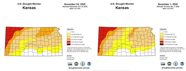
Figure 2. Drought monitor last week (November 24, 2020 - left) and this week (December 1, 2020 - right) via the Drought Monitor (droughtmonitor.unl.edu).
Climate trends - A moderate La Niña event is underway in the east Pacific. Colder than normal water at and below the surface suggests it will remain through most of the winter. This typically spells warmer (averaged between swings of warm/cold periods) and drier conditions for the state of Kansas into spring. However, as we have already seen with the recent storms, periods of moisture are definitely still possible for the east, but will be much harder to come by for western Kansas. In addition, the next few months are typically the driest months of the year - therefore, any moderate precipitation event can easily skew statistics from a “dry” winter to a “wet” winter.
Another concern for Kansas relies on the mountains to our west. Much of the west resides in an exceptional, and growing, drought. While precipitation across the Southwest and Rocky Mountains have been increasing in recent weeks - these long term deficits will play a role in incoming Pacific moisture, as well as system dynamics, to bring Gulf moisture northward. Current models depict a dry March across the southwest US (Figure 3). La Niña’s aren’t very beneficial to the southwest and if the dry predictions verify, expect an increase in dry systems to impact Kansas in early spring - usually an indicator of an active fire season.
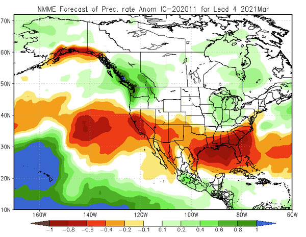
Figure 3. Precipitation rate anomalies using the NMME via NOAA (https://www.cpc.ncep.noaa.gov/products/NMME/monanom.shtml).
Spring 2021 forecast
This spring, we expect an average, to slightly above average Kansas fire season. This would entail an increased number of large fires than in the last two springs.
The Kansas recipe for large fires typically includes a dynamic storm system with wind shifts and associated dry fronts. While antecedent dry conditions can aid in extreme fire behavior, most large fires have fallen into a “gray” area that aren’t specifically in extreme drought but see enough drying to exhibit spotting concerns and suppression difficulty. Light flashy fuels (one hour fuels) are the primary carrier with poor humidity recovery and larger burn windows required for large fires.
With all indications of warmer than normal conditions over the next few months, increased evaporation and breezy dry frontal passages are preferred and will be exacerbated in dry conditions. This will be especially a concern for the northwest if they continue to miss out in precipitation leading into March. With above normal fuels, focus will also be on the southern portion of the state (Figure 4). While we will definitely receive some needed rain/snow as we have observed over the past few weeks, the positive impacts are rapidly diminished with these warm/dry periods which will be common this winter.
Normally, the fire season runs from late February to as late as mid-April. With warmer than normal temperatures, early green up will be likely should there be suitable moisture. There are some indications that the season will be shorter than normal for portions of east and south-central Kansas as moisture becomes more widespread with a possibly active spring storm season.
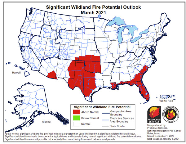
Figure 4. Significant wildland fire potential outlook from National Interagency Fire Center Predictive Services (https://www.predictiveservices.nifc.gov/outlooks).
Highlights
- Timely green up, and warmer than normal temperatures aided in a below average 2020 spring fire season.
- Grass fuel loading varies by location but remains generally above normal in areas of north-central and south-central Kansas.
- Prominent La Niña conditions are expected to result in warmer than normal temperatures and drier than normal predictions this winter.
- Kansas fire season (Feb - Apr) is expected to be average to slightly above average with an increased number of large fires than the last two spring seasons.
Christopher “Chip” Redmond - Kansas Mesonet
christopherredmond@ksu.edu
Mary Knapp - Weather Data Library
mknapp@ksu.edu
Eric Ward - Kansas Forest Service
eward@ksu.edu
Tags: wildfire fire weather