The meteorological winter of 2025-26 began on December 1, 2025, and concluded on February 28, 2026. This 90-day period was one for the record books, as it contained unseasonably warm temperatures and, for some areas, unusually dry conditions. In this report, we take a look back at the past three months and some of the records that were set.
Temperature Summary
The average temperature for the winter of 2025-26 in Kansas was 37.9° F. While that may sound cold, it was nearly five degrees above the 30-year average (1991-2020) of 33.0°. More significantly, it was the second warmest of the past 131 winters, based on data from the National Centers for Environmental Information that dates back to 1895. We didn’t miss the record by much; we finished two-tenths of one degree below the record warmest winter: 38.1° set in 1991-92. Still, it was Kansas’ warmest winter in 34 years!
If we look at individual divisions within the state, western Kansas was the most above-normal area (Table 1/Figure 1). Northwest Kansas averaged +7.0° above normal, easily setting a new record for the warmest winter in that division by 2.2 degrees! The previous record warmest winter in northwest Kansas was 35.8° in 1999-2000. West central and southwest Kansas also set new records for the warmest winter, west central by 2.0 degrees and southwest by 1.9 degrees. Even the two divisions that were the least above normal, northeast and southeast, managed top-10 warmest winters (10th in northeast, 7th in southeast) by finishing 3.5° above normal. Within individual counties, 32 set new records for warmest winter, with Cheyenne (+7.9°) and Sherman (+7.8°) the most above normal in the state. Even Linn County, the least above normal, was still 2.8° above normal. Impressively, just over two-thirds of Kansas’ 105 counties, 71 in all, had a top-5 warmest winter, and 20 more ranked between 6th and 10th warmest. Doniphan County had the lowest ranking at 16th warmest.
Table 1. Divisional departures from normal for precipitation and temperature in Kansas during the winter of 2025-26 (Source: NCEI).
|
Dec. 2025 – Feb. 2026 |
Precipitation |
Temperature |
|||||||
|
Total (in.) |
Dep. (in.) |
% of Normal |
Rank Wettest |
Rank Driest |
Avg. (°F) |
Dep. (°F) |
Rank Warmest |
Rank Coldest |
|
|
Northwest |
0.71 |
-0.79 |
47 |
106 |
24 |
38.0 |
+ 7.0 |
1 |
131 |
|
North Central |
1.58 |
-0.85 |
65 |
81 |
51 |
35.5 |
+ 4.9 |
2 |
130 |
|
Northeast |
2.22 |
-1.03 |
68 |
91 |
41 |
33.9 |
+ 3.5 |
10 |
122 |
|
West Central |
1.20 |
-0.38 |
76 |
73 |
58 |
38.8 |
+ 6.5 |
1 |
131 |
|
Central |
1.62 |
-1.15 |
58 |
90 |
42 |
37.1 |
+ 4.4 |
2 |
130 |
|
East Central |
3.07 |
-0.81 |
79 |
75 |
57 |
36.6 |
+ 3.7 |
7 |
125 |
|
Southwest |
0.89 |
-0.83 |
52 |
93 |
38 |
40.1 |
+ 5.8 |
1 |
131 |
|
South Central |
1.36 |
-1.64 |
45 |
101 |
31 |
39.3 |
+ 4.4 |
2 |
130 |
|
Southeast |
2.51 |
-2.04 |
55 |
112 |
20 |
39.1 |
+ 3.5 |
7 |
124 |
|
STATE |
1.66 |
-1.09 |
60 |
98 |
34 |
37.9 |
+ 4.9 |
2 |
130 |
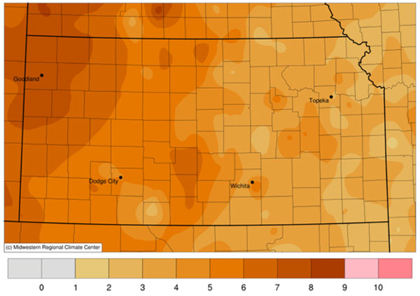
Figure 1. Map of departures from normal temperature during the winter of 2025-26. Source: Midwest Regional Climate Center.
Of the 90 days in meteorological winter, 64 of them averaged above normal, based on data from the Kansas Mesonet. The longest stretch of below normal weather was from January 22 through 31, the only Arctic outbreak of the winter, when temperatures as cold as -20° were recorded by the Mesonet sites in Saline and Osborne Counties. By contrast, the Harper and Chautauqua County sites never recorded a low below zero this winter; both recorded seasonal minimums of +1°. The towns of Medicine Lodge (+2°) and Coffeyville (+1°) also stayed above zero all winter. Highs at or above 70 degrees were far more common across the state. The Mesonet site in Stevens County reached that mark 24 times during winter. Elkhart (23), Syracuse (23), Liberal (22), and Cimarron (21) all hit 70 at least 20 times during the winter. Goodland reached 70° thirteen times during winter, six more than their previous high count, which last occurred 40 years ago. Goodland’s warmest December on record was followed by its second warmest February. February 2026 finished just one-tenth of one degree below the record set in 1930. But Goodland’s warmth contributed to Sherman County achieving a double superlative this past winter: warmest December and warmest February, a feat matched by Rooks and Stanton Counties.
Precipitation Summary
As for precipitation, the average for the winter of 2025-26 was 1.66”. This was 1.09” below the normal of 2.75” and ranked as the 34th driest winter on record. All nine divisions in the state were below normal, with percents of normal ranging from 45% in south central to 79% in east central Kansas (Table 1/Figure 2). Northwest Kansas averaged just 0.71” for winter, which ranked as the 24th driest. Within this division, Decatur County averaged only 0.30” for winter, making it their third driest winter on record, and the driest in over a century, since a 0.19” average back in 1923. In all, 21 counties averaged 1 inch or less of precipitation for the entire winter.

Figure 2. Map of total precipitation during the winter of 2025-26. Source: Southern Regional Climate Center.
One reason for the high rankings on the lists of driest winters in this area was a lack of snowfall (Figure 3). Goodland received only 4.1 inches of snow during the winter, their lowest total in 80 years. That is about 1 foot below their winter normal of 16.2 inches. A few locations had even less snow than Goodland, such as Oberlin (3.0”) and Atwood (3.3”). The lowest snowfall total in the state was 2.1”, reported by two CoCoRaHS observers: one north-northwest of Traer in Decatur County and the other 12 miles northwest of Goodland in Sherman County. Where did it snow the most? That honor goes to Hamilton County, where the CoCoRaHS observer 7 miles west-southwest of Syracuse measured 18.0” for the winter. Other double-digit totals for the winter include 14.1” at Utica, 13.5” at Johnson City, 11.9” at Topeka, and 10.6” at Clay Center.
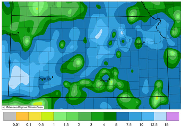
Figure 3. Total snowfall during the winter of 2025-26. Source: Southern Regional Climate Center.
Where was the most precipitation? East central Kansas had the highest divisional average with 3.07”, with Coffey (3.82”) and Franklin (3.72”) Counties the wettest. The co-operative observer near Williamsburg in Franklin County recorded the most winter precipitation, picking up 5.91”. Nearly 70% of this total came from a single rainfall event on February 13-14, when 4.10” fell. Even with a few bright spots, every county in the state averaged below normal for the winter. Greeley and Lyon Counties were closest to normal, each just 0.01” below normal. A total of 56 of Kansas’ 105 counties averaged at least one inch below normal, and eleven of those were at least two inches in arrears. Cherokee County had the largest departure from normal: -3.56”. It’s important to note that Cherokee also averages more precipitation than any other county in the state during winter, normally receiving just over 6 inches (6.02”). But of the four other counties in the state that average 5 or more inches of precipitation in winter, all were at least 2 inches below normal. Southeast Kansas averaged a little over two inches below normal (-2.04”), and it was the 20th driest winter in that division.
Matthew C. Sittel, Assistant State Climatologist
msittel@ksu.edu
Tags: Climate winter weather weather