The meteorological winter of 2023-24 began on December 1, 2023, and ended on February 29, 2024. This past winter was the 129th in the National Centers for Environmental Information (NCEI) climate record, which is continuous all the way back to the winter of 1895-96. NCEI’s records include average temperature and precipitation information for the entire state, each of Kansas’ nine climate divisions, and for all 105 counties. In this report, we take a look back at the winter of 2023-24 and where it ranks compared to previous winters.
December 2023
December was an unseasonably mild month. There were only 7 days in December when the average temperature was below normal. The temperature never fell below zero anywhere in the state; the coldest reading was 5°F at the Hamilton County Mesonet site on the 10th. The 6th and 7th were the warmest days of the month, when highs were in the 60s and 70s statewide, with a few locations reaching nearly 80 degrees. Over 40 daily record highs were set on the 7th. This helped to make December 2023 the second-warmest on record, with a statewide average temperature for the month of 39.2°F, or a departure from normal of +6.0°F. The only December warmer than 2023 was two years ago in 2021 (41.1°F). Divisional departures from normal for the month ranged from +4.8°F to +6.7°F (Table 1). While no county experienced its warmest December on record, it was the second warmest in 43 counties. All counties finished in the top 8 warmest on record.
Table 1. Average monthly/seasonal temperatures (bold), in degrees Fahrenheit, departures from normal (in parentheses) and ranks of each amongst all years, dating back to 1895, by Kansas climate division. Source: National Centers for Environmental Information. Ranks preceded by a “T” indicate a tie with at least one other year.
|
Division |
Dec 2023 |
Jan 2024 |
Feb 2024 |
Winter |
|
Northwest |
36.0° (+5.0°) 5th warmest |
24.0° (-5.8°) 31st coldest |
41.4° (+8.8°) T 2nd warmest |
33.8° (+2.8°) 8th warmest |
|
North Central |
37.3° (+6.2°) 2nd warmest |
23.2° (-5.2°) 32nd coldest |
43.2° (+10.7°) 2nd warmest |
34.6° (+4.0°) 4th warmest |
|
Northeast |
38.2° (+6.7°) T 3rd warmest |
23.6° (-4.1°) T 34th coldest |
43.4° (+11.0°) 2nd warmest |
35.1° (+4.6°) 2nd warmest |
|
West Central |
36.9° (+4.8°) 6th warmest |
24.9° (-6.1°) 27th coldest |
42.5° (+8.5°) 3rd warmest |
34.8° (+2.5°) 10th warmest |
|
Central |
39.0° (+6.1°) 2nd warmest |
24.7° (-6.0°) 27th coldest |
44.4° (+9.7°) 3rd warmest |
36.0° (+3.3°) 6th warmest |
|
East Central |
40.5° (+6.7°) 2nd warmest |
25.6° (-4.6°) 29th coldest |
45.5° (+10.7°) 2nd warmest |
37.2° (+4.3°) 2nd warmest |
|
Southwest |
39.2° (+5.4°) T 3rd warmest |
28.2° (-4.7°) T 32nd coldest |
44.5° (+8.1°) 3rd warmest |
37.3° (+3.0°) 8th warmest |
|
South Central |
41.2° (+6.4°) 2nd warmest |
28.1° (-4.9°) 30th coldest |
46.1° (+9.1°) 3rd warmest |
38.5° (+3.6°) 2nd warmest |
|
Southeast |
42.4° (+6.3°) 2nd warmest |
28.3° (-4.8°) 27th coldest |
47.4° (+9.8°) T 1st warmest |
39.4° (+3.8°) T 3rd warmest |
|
STATE |
39.2° (+6.0°) 2nd warmest |
25.9° (-5.2°) 28th coldest |
44.5° (+9.5°) 3rd warmest |
36.5° (+3.5°) 4th warmest |
Precipitation was well above normal during the month. Much of the precipitation that fell in the state in December came from two events. The first event lasted from the 13th to the 15th, and the other from the 24th to the 26th. Southwest Kansas had the most precipitation with the first event, and with mild temperatures in place, it was primarily a heavy rain event rather than snow, but there were some reports of freezing rain at the onset of the event. Rainfall totals of 2 to 3 inches were common across many counties in the southwest, with a 3.59” total from Meade County, the highest storm total reported. Eastern Kansas received the most rainfall from the second event, with most areas picking up from 1 to 2 inches of rain, but there were isolated higher amounts of over two inches in the Kansas City, Topeka, and Emporia areas. The second event was primarily rain, but colder air behind the departing storm system brought snow to some areas. Heavy snow fell in the northwest, where as much as 8.5” was measured in Cheyenne County. Totals from 3 to 5 inches were common in north central Kansas, with 1 to 2 inches in northeast Kansas.
The average statewide precipitation for December was 2.16”, or 1.09” above normal. This ranked as the 9th wettest December on record in Kansas. The highest-ranked division was southwest Kansas (3rd wettest) (Table 2). The remaining divisions finished in the top 15 except for northwest Kansas, where it was the 22nd wettest December. Nearly half of Kansas’ 105 counties 45 had a top 10 wettest December, and 16 of those ranked in the top five. The highest ranking was third wettest, shared by seven counties: Cowley, Gray, Greenwood, Haskell, Meade, Seward, and Stevens.
Table 2. Average monthly/seasonal precipitation (bold), in inches, departures from normal (in parentheses) and ranks of each amongst all years, dating back to 1895, by Kansas climate division. Source: National Centers for Environmental Information (NCEI). Ranks preceded by a “T” indicate a tie with at least one other year.
|
Division |
Dec 2023 |
Jan 2024 |
Feb 2024 |
Winter |
|
Northwest |
0.85” (+0.30”) 22nd wettest |
0.54” (+0.13”) T 33rd wettest |
1.09” (+0.55”) T 17th wettest |
2.48” (+0.98”) 12th wettest |
|
North Central |
1.68” (+0.75”) 12th wettest |
1.04” (+0.40”) T 17th wettest |
1.03” (+0.18”) 38th wettest |
3.75” (+1.32”) 13th wettest |
|
Northeast |
2.33” (+1.03”) 14th wettest |
1.74” (+0.95”) 11th wettest |
0.57” (-0.60”) 35th driest |
4.64” (+1.39”) T 18th wettest |
|
West Central |
1.19” (+0.61”) 10th wettest |
1.00” (+0.57”) 12th wettest |
0.93” (+0.36”) 23rd wettest |
3.12” (+1.54”) 9th wettest |
|
Central |
2.18” (+1.12”) 11th wettest |
1.34” (+0.63”) 11th wettest |
1.01” (+0.00”) 48th wettest |
4.53” (+1.76”) T 8th wettest |
|
East Central |
2.83” (+1.32”) 13th wettest |
2.20” (+1.23”) 12th wettest |
1.03” (-0.39”) T 56th driest |
6.06” (+2.18”) 7th wettest |
|
Southwest |
2.14” (+1.41”) 3rd wettest |
0.87” (+0.38”) 18th wettest |
0.64” (+0.14”) 48th wettest |
3.65” (+1.93”) 5th wettest |
|
South Central |
2.65” (+1.50”) 9th wettest |
1.30” (+0.51”) T 18th wettest |
0.90” (-0.19”) 57th wettest |
4.85” (+1.85”) 12th wettest |
|
Southeast |
3.12” (+1.35”) 15th wettest |
1.84” (+0.62”) T 28th wettest |
1.52” (-0.07”) T 49th wettest |
6.48” (+1.93”) 14th wettest |
|
STATE |
2.16” (+1.09”) 9th wettest |
1.31” (+0.59”) T 16th wettest |
0.98” (+0.01”) 48th wettest |
4.45” (+1.70”) 4th wettest |
January 2024
Unlike December, January was colder than normal, thanks partly to an Arctic air mass that plunged the state into a deep freeze in the middle of the month. There were thirteen consecutive days with below-normal temperatures, from the 9th through the 21st, with the period from the 13th through the 15th being the coldest days in the state in nearly three years. The average high in Kansas on all three of those days was below zero, some 35 degrees below normal readings. Morning lows fell to -10°F or colder at most locations, with a few places registering four consecutive mornings below that mark from the 13th through the 16th. The Wallace County Mesonet site dropped to -22°F on the 15th, the coldest reading in the state since February 2021. Temperatures rebounded starting on the 22nd and stayed above normal for the remainder of the month. The month finished 5.2°F below normal, placing January 2024 as the 28th coldest on record. All nine divisions finished the month below normal; departures ranged from -6.1°F to -4.1°F.
There was more snow in January than in December. Early in the month, an event on the 4th and 5th brought as much as 5 inches of snow to southern and eastern Kansas. The most significant precipitation event during the month was a major winter storm on the 8th. Precipitation fell entirely as snow in the west and changed from rain to snow in the northeast quarter of the state as colder air overspread the state. Up to 14” of snow was measured in Scott County. Totals from 10 to 12 inches were reported in parts of western and eastern Kansas. Dodge City’s 8.1” of snow on the 8th was their second-highest 1-day snow total in the last 15 years. High winds accompanied the snow in the west, leading to blizzard conditions. Additional rounds of light snow accompanied the Arctic air, adding up to as much as 8” of snow in Washington County. Precipitation on the 21st through the 23rd fell into warmer air, but with surface temperatures near to below freezing, the result was freezing rain in some parts of southeast Kansas. The combination of all the precipitation events resulted in above-normal precipitation in all divisions for the month. The average precipitation for January across Kansas was 1.31”, or 0.59” above normal, ranking it as the 16th wettest January on record. Divisional rankings for wettest January ranged from 11th in both northeast and central Kansas to 33rd in northwest Kansas. Four counties had their fifth wettest January on record: Geary, Pottawatomie, Stafford, and Wabaunsee. Seventeen additional counties had a top 10 wettest January. Every county finished in the top 30.
February 2024
February was much like December with respect to temperatures, as mild weather dominated the month. There were just four days when the average temperature across the state was below normal. On nearly half the days (14 of 29), temperatures averaged at least 10 degrees above normal. There were no subzero readings anywhere in the state; the coldest temperature recorded by the Kansas Mesonet in February was 3°F at the Decatur County site on the 17th and in Wallace County on the 28th. The warmest readings occurred in the latter half of the month. The average high temperature across the state exceeded 70°F on the 20th and 21st, and the first 80-degree reading of the year came on the 21st when Medicine Lodge in Barber County reached 82°F. The month finished with a mean temperature of 44.5°F or 9.5°F above normal. February 2024 was the 3rd warmest on record and the warmest February in 70 years, finishing behind only 1954 (44.9°F) and 1930 (45.1°F). All divisions notched a top 3 warmest February, with one superlative: Southeast Kansas tied 1930 for their warmest February on record. It was also the warmest February on record in 13 counties, and all 105 counties finished in their top 3 warmest except for Morton County in far southwestern Kansas, where 2024 ranked as 4th warmest. In 42 of Kansas’ 105 counties, the average temperature in February was at least 10 degrees above normal, with Brown County the most above normal (+11.8°F). The least above normal was Greeley County, with a departure of +6.9°F.
The only significant precipitation event occurred early in the month, and with above-normal temperatures in place, there was only liquid precipitation. From the 2nd through the 4th, much of northern and eastern Kansas received over an inch of rainfall. Higher totals were reported in north central Kansas, as a CoCoRaHS observer in Rooks County measured 2.58”. There were two minor snow events during the month. Western and southern Kansas picked up measurable snow on the 10th through the 12th, with the highest totals in Labette County where nearly 5” of snow fell. Additional snow fell on the 15th through the 17th, with northern and western counties generally receiving 1 to 3 inches of snow, but there were isolated totals of up to 5 inches of snow in Decatur and Rawlins Counties. The early month rainfall event ensured February would finish with above-normal precipitation in some of Kansas’ climate divisions for the third straight month. The statewide average monthly precipitation was 0.98”, or 0.01” above normal. Four of Kansas’ nine divisions finished the month below normal, and one was exactly normal. The remaining four divisions were above normal, with northwest Kansas ranking highest at 17th wettest.
Winter 2023-24
Considering the past three months as a winter season, the winter of 2023-24 was both the fourth warmest and the fourth wettest on record. It was the warmest winter in eight years but the wettest winter in over 30 years, since 1992-93 (Table 3). While no division or county recorded their warmest or wettest winter on record, a few achieved runner-up status. It was the second-warmest winter in three divisions: northeast, east central, and south central, as well as in 18 counties (Figure 1). Southeast Kansas had its third-warmest winter, as did 21 additional counties. All divisions managed a top-10 finish, as did 95 of Kansas’ 105 counties. The lowest-ranking division was west central Kansas (10th), while Greeley and Wallace Counties tied for the lowest-ranked county (13th). With respect to precipitation, four divisions recorded a top 10 wettest winter. Of these, southwest Kansas was the highest ranked at 5th. In nearly half of Kansas’ 105 counties, 48 had a top 10 wettest winter (Figure 2). Eleven of those managed a top 5 finish, and three finished in 2nd place: Osage, Seward, and Stevens. All three missed out on their wettest December by less than two-tenths of an inch.
Table 3. The five wettest and warmest winters on record in the state of Kansas. Source: NCEI.
|
Total Precipitation (in.) |
Rank |
Average Temperature (°F) |
||
|
Years |
Value |
Years |
Value |
|
|
1984-1985 |
5.34” |
1 |
1991-1992 |
38.1° |
|
1992-1993 |
5.11” |
2 |
1999-2000 |
37.0° |
|
1918-1919 |
4.50” |
3 |
2015-2016 |
36.8° |
|
2023-2024 |
4.45” |
4 |
2023-2024 |
36.5° |
|
2006-2007 |
4.44” |
5 |
1975-1976 |
36.4° |
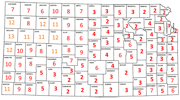
Figure 1. Rank of the winter of 2023-24 on each Kansas county’s list of its warmest winters on record. Source: NCEI.
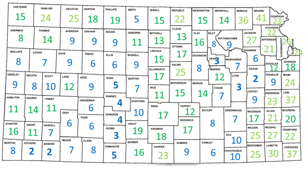
Figure 2. Rank of the winter of 2023-24 on each Kansas county’s list of its wettest winters on record. Source: NCEI.
The overall departure from normal temperature for the state of Kansas this past winter was an impressive +3.5°F. As unseasonably mild as we were, Kansas was nowhere near the most above-normal state. Believe it or not, there were 25 states that finished their winter more above normal than we were! As a result, the winter of 2023-24 will go down in the record books as the warmest winter on record in the lower 48 United States. The lower 48’s average temperature of 37.60°F was 0.82°F above the previous record holder, the winter of 2015-16. Eight states registered their warmest winter on record (Figure 3a), all in the northern part of the country: North Dakota, Minnesota, Iowa, Wisconsin, Michigan, New York, Vermont, and New Hampshire. Minnesota was the most above-normal state in the country this past winter; their average departure from normal was an amazing +11.3°F. This mark was 2.7°F ahead of their previous warmest winter (1997-98). Neighboring Wisconsin was next highest with an anomaly of +9.8°F, a new record by 2.2°. One reason for the record warmth in these northern states was a lack of snowfall. Duluth, MN, averages 90” of snow annually. Since July 1, 2023, Duluth has had only 19” of snow. Should no more snow fall between now and June 30th, this will be the least-snowiest year on record there by about 8 inches. Despite some areas lacking snow, it was a wet winter in many parts of the country, Kansas included. Overall, 2023-24 ranked as the 21st wettest winter for the entire lower 48 (Fig. 3b). Kansas’ ranking of 4th wettest was an anomaly in this part of the country. Our neighbor to the east, Missouri, finished at 61st wettest. Our other three neighbors ranked higher on their respective lists of wettest winters on record but nowhere close to our finish: Colorado finished at 36th wettest, Oklahoma at 18th wettest, and Nebraska was highest at 14th wettest. Only two states finished higher than we did; 2023-24 was the third wettest winter in Connecticut and Delaware.
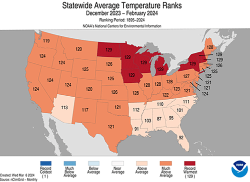
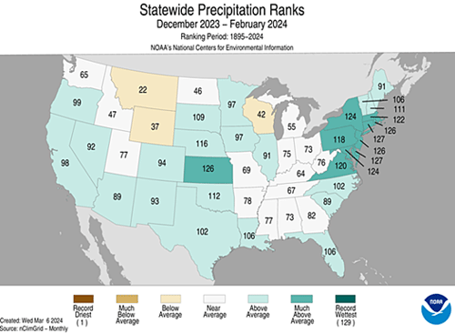
Figures 3a-b. Ranking of each state on the list of coldest (top) and driest (bottom) winters. Kansas’ ranking of 126th coldest corresponds to 4th warmest, and 126th driest corresponds to 4th wettest. Source: NCEI.
Could we be in line for the warmest spring on record? We are off to a good start. Through the first 12 days of March, the statewide average temperature is running 6.2°F above normal. If we were to finish March that much above normal, it would be the 4th warmest March on record. Time will tell if we can sustain this extended stretch of mild conditions; stay tuned!
Matthew Sittel, Assistant State Climatologist
msittel@ksu.edu
Tags: winter winter weather weather