Spring is a critical time for growers as it is when the most essential agricultural decisions are made. During this time, fields are scouted to monitor crop residue cover, standing water, weed presence, plant stand counts, and nutrient status. Such monitoring can help to make decisions such as the proper planting time, replanting decisions, weed control, drainage, and fertilizer application plans, which will impact the overall crop yield of the year. Therefore, early season field scouting is essential and significantly affects our ability to make all our early season management decisions. Generally, such monitoring is done by walking or driving through the field in a zigzag or ‘W’ shape pattern and is quite accurate; however, it might be challenging as it is time-consuming, labor intensive, and only describes a limited portion of the field.
The advancement of precision agriculture technology, such as drones, can provide an efficient solution for early-season field scouting. In contrast to traditional scouting, drone scouting can be less time-consuming, have more thorough field coverage, and be less labor intensive. Such a drone has a sensor or camera that can provide a bird’s-eye view of the whole field and complete scouting in 15–30 minutes, depending on the field size.
Drone types
Three different types of drones and sensors are used in scouting agricultural fields. The most used drones are fixed-wing and multi-rotary. Fixed wings, which have wings that give a small airplane look, usually have more considerable coverage due to longer battery life (Figure 1). Still, their limitation is that they cannot hover around any particular area while flying. Moreover, fixed-wing drones need larger take-off and landing areas, as they cannot do vertical take-off and landing. On the other hand, multi-rotary types of drones have rotating propellers, and compared to fixed wings, they generally have slower speeds and less coverage. However, they can hover around certain areas to scout specific field parts. The third type of drone is a hybrid drone with features including fixed wings and a multi-rotor.
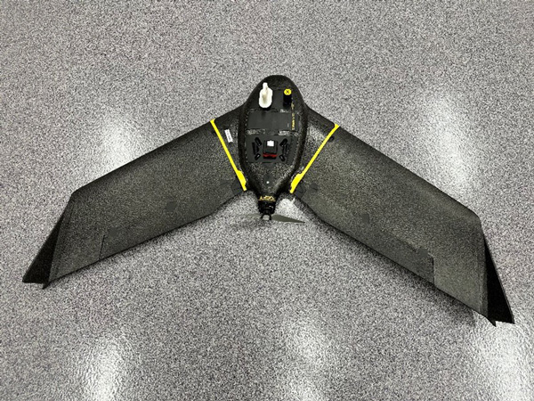
Figure 1. Fixed wing drone with multi-spectral sensor that can be used for agricultural field scouting. Photo by Deepak Joshi, K-State Research and Extension.
Sensor types
Two types of sensors are particularly used for scouting purposes. The first is an ‘RGB camera, which can detect only visible lights reflected by objects, i.e., Red, Green, and Blue, as our human eyes do. Such RGB camera-based drones provide true–color images of the field (Figure 2-left) and can be useful in visual assessments such as counting plants, detecting weeds, and more. Another type of sensor used is a multi-spectral sensor that can capture additional spectrum of lights beyond visible lights, such as near-infrared (NIR). Various vegetation indices can be calculated using multispectral sensor imagery, such as Normalized Difference Vegetation Indices (NDVI), Green Normalized Difference Vegetation Indices (GNDVI), etc. (Figure 2-right). These can provide more information than the RGB camera, including the soil nutrient and moisture status, plant disease, and weed identification not provided by visible lights.
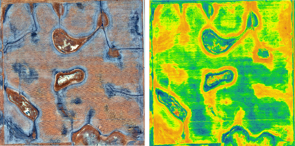
Figure 2. A true-color image (left) and a GNDVI map (right) of the field were collected using a drone during the early season to monitor standing water, weed patches, early germination, and canopy coverage. Darker areas in the true-color image indicate higher soil moisture or standing water; brown areas represent plant density; dark brown with rough texture represents weed patches. Similarly, in the GNDVI map, darker green indicates higher plant density or greater canopy coverage. Images provided by Deepak Joshi, K-State Research and Extension.
Besides sensor/camera quality, flight altitude also impacts the quality of the image. For example, the higher the flight altitude, the lower the ground resolution, and vice versa. However, a lower flight altitude covers less ground area per image and might take longer to cover the entire field. So, it is all about finding the right balance based on our scouting goal. In general, flight altitudes of 200-400 feet are commonly used for precision agriculture scouting. Also, it is essential to remember that the FAA regulations don’t allow the drone to be flown higher than 400 feet above ground. More details about FAA rules and regulations can be found at https://www.faa.gov/uas?utm_source=chatgpt.com.
Using images collected by the drone, NDVI, GNDVI, or true color images can be derived, and based on such field maps, we can use them to monitor crop emergence, soil moisture monitoring, weed pressure, and soil nutrient status. Therefore, such drone-based tracking can be used to make multiple early-season management decisions. It can detect walking through the field and monitoring the crop and field, which often might take an entire morning; however, with a drone, you can assess field conditions in a fraction of the time. It is quicker and can provide entire field monitoring, including the areas that are difficult to reach. Aerial scouting should supplement ground truthing for issue spots when applicable.
Deepak Joshi, Precision Ag Specialist
drjoshi@ksu.edu
Jeremie Kouame, Weed Scientist – Hays
jkouame@ksu.edu
Sarah Lancaster, Extension Weed Scientist
slancaster@ksu.edu
Logan Simon, Southwest Area Agronomist
lsimon@ksu.edu
Tina Sullivan, Northeast Area Agronomist
tsullivan@ksu.edu