Modern-day precision agriculture relies heavily on sensor technology, and among these, remote sensing is the most widely used tool. The term remote sensing consists of two words, “remote”, which means from a distance, and “sensing”, which means the collection of information or data. Therefore, remote sensing refers to studying or collecting information about objects such as crops, soil, water, or the surrounding environment from a distance, without direct contact.
Common examples of remote sensing are drone and satellite imagery, as well as handheld devices or sensors mounted on any of our farm equipment, such as tractors. These technologies use sensors to measure sunlight reflected by the crops and soil to create a map that can be used to understand the crop health, soil condition, and water stress, which our eyes usually cannot see (Figure 1).
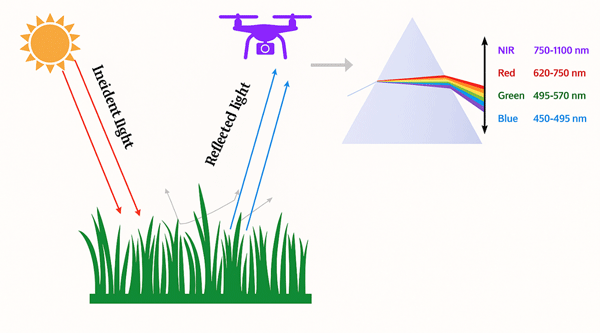
Figure 1. Illustration of the principle of drone-based remote sensing: Sunlight travels to the Earth, reflects off crop canopies or soil, and is captured by drone-mounted sensors in different spectral bands (blue, green, red, NIR, etc) to monitor and assess crop and soil conditions. Image credit: Deepak Joshi, K-State Research and Extension.
Application of Remote Sensing in Agriculture
Understanding field variability: Each field is unique and consists of different soil types, soil nutrients, moisture levels, disease, and pest pressure. Due to these reasons, crop growth is not uniform throughout the same field. Therefore, remote sensing can help farmers to understand such variability of crop growth by creating maps of the fields (Figure 2).
For example, a drone was flown to collect field variability information at the Flickner Innovation farm in McPherson County. In such collected drone imagery, green areas represent higher canopy cover, healthier crops, and better growth. Yellow areas indicate moderate crop vigor, while red areas show little to no canopy cover, corresponding to reduced growth, bare soil, and equipment tracks, particularly caused by pivot irrigation. Such maps provide valuable insights for monitoring and managing field variability using drone-based remote sensing.
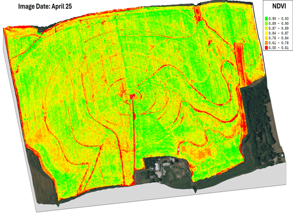
Figure 2. Crop growth variability within the same field based on NDVI derived from drone imagery. Image credit: Deepak Joshi/Flickner Innovation Farm.
Crop stress detection: Remote sensing can help farmers by detecting the early signs of crop stresses such as nutrient deficiency, moisture issues, disease, and pests that may not be seen early enough with the naked eye. Such information can be used as a guide for site-specific nitrogen, irrigation, or pesticide applications by applying inputs only in the areas where it is needed.
Weed identification: High-resolution remote sensing images, especially using drones, can help identify the weeds in the fields. As the weeds have different colors, leaf structure, shape, or growth patterns compared to the crops, using remote sensing, we can identify them to create a weed map of the field. These weed maps can be used for site-specific herbicide application using spray drones or any other farm applicators.
Different types of remote sensing tools
- Satellite: Satellite images are now used for various on-farm decisions, including variable-rate technology. Satellites provide large-scale imagery that can cover an entire farm, county, state, or even the whole earth. Many satellite datasets, such as Sentinel-2 and Landsat, are freely available at no cost, which can be used by growers for various on-farm decisions. However, weather conditions, especially cloud cover, can affect the availability and quality of these images.
- Drones: Drones provide high-resolution images and can capture crop and soil information at the centimeter level. They can also be flown as needed, offering greater flexibility. Drone imagery is commonly used for early-season scouting, detecting crop stress, and identifying weeds.
- Handheld sensors: Some sensors can be handheld or mounted on farm equipment to collect information about soil and crops. Common handheld sensors used in agriculture include CropScan, GreenSeeker, fluorometers, and chlorophyll meters.
Conclusion
Remote sensing has become very popular and is accessible to farmers to make more informed and smarter decisions. This technology can help farmers to “see” crops and soil conditions that are not visible to the naked eye, thus allowing for more timely and precise decisions on their farms.
Deepak Joshi, Precision Ag Specialist
drjoshi@ksu.edu
Matias Lucero, Research Scholar
Sangam Bishwakarma, Graduate Student
Kaden Spencer, Graduate Student