As we approach spring, this means the return of Kansas wildfire season, which usually peaks before vegetation initiates greenup. Recent cold/snow has provided another slow start to the fire season across the state. This is an ideal time to increase awareness, check equipment, and consider environmental conditions and how they may impede fire suppression or prescribed fire.
2024 drought and precipitation impacts to vegetation
Drought persisted through the state in 2024. However, it underwent several shifts and remains in focus for northern and eastern areas of Kansas. Surprisingly, the driest part of the state, the southwest, was the region that observed the most rainfall compared to normal. This region had significant cool/warm season grass. These considerations are then justified by on-the-ground observations to create a statewide map of grass growth in the state (Figure 1). This grass is considered a “fuel” for wildfires and is the primary fire carrier in the state. Above-normal grass/fuel results in increased/erratic fire behavior on the landscape, even in benign weather conditions. Additionally, despite drought in the northeast portion of the state, timely precipitation helped drive above-normal grass growth in the northeast. Outside of these regions, persistent drought with less timely rainfall provided an area of below-normal grass growth in northwest and much of central Kansas.
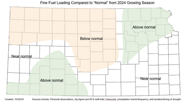
Figure 1. Areas of estimated above/below/at normal grass (or fuel) loading. Above-normal areas observed increased moisture during the growing season and have potentially more potential for increased fire behavior and large fire potential. The opposite is expected in the below-normal area. Estimates from numerous sources were also considered. Source: Kansas Forest Service and Kansas Mesonet.
Weather patterns play an important role
As we enter spring 2025, the overall weather setup is much different than that of 2024 when we had El Niño in the east Pacific. This year, we have a weak La Niña, which means the tracks of low-pressure systems (Figure 2) tend to track across the US differently. La Niña favors a track that typically places Kansas in the southwest quadrant of these storms. The southwest is characterized by much warmer/drier conditions from the desert southwest transported northeast into the region. This provides a pattern much more favorable for large fires in the state. In fact, Kansas sees almost a triple of acres burned in La Niña springs compared to El Niño.
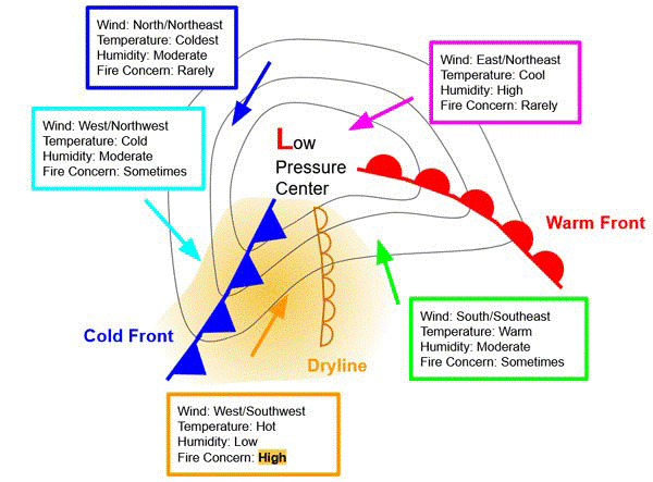
Figure 2. Diagram depicting a surface low-pressure system responsible for the most active weather on the Plains. Significant wildfires may develop south of the low-pressure center between the dryline and the cold front.
Looking at the southwestern US, drought has continued to expand and slowly move northeast over the last few months. Therefore, when the air is pushed into the region with these storm systems, they will be characterized by even warmer/drier conditions than normal. This can aid in more potent fire weather conditions, especially for Kansas's west and central portions. When we combine these atmospheric conditions with the increased fuel loading, we have a recipe for large to significant wildland fires this spring.
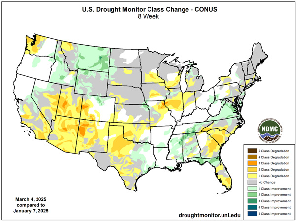
Figure 3. Drought changes over the last two months (eight weeks). Note the expansion of several drought categories in the southwest as conditions continue to degrade under typical La Niña conditions. Source: United States Drought Monitor.
The forecast for the 2025 wildfire season
With climatology and the fuel landscape, the conditions exist for large fire potential this spring, especially considering last year's quieter-than-normal fire season. However, a few elements still need to align to bring this forecast to fruition. Thus far in 2025, the weather pattern has favored the storm systems to track just slightly further south. This has allowed for cold air and snowfall for January and February - keeping fire danger in check. However, as noted with this week’s potent windstorm, they are beginning their seasonal transition northward. With an active storm pattern expected, Kansas will gradually start observing more fire weather with each. This is apparent considering the forecasts of lower humidity and higher windier-than-normal conditions favored for the next week of March (Figure 4). This is potentially more amplified by widespread drier-than-normal conditions favored with models for April (Figure 5).
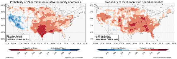
Figure 4. Favored humidity (left) and wind (right) compared to normal for March 14-20, 2025 from the Climate Prediction Center using beta NOAA/Earth System Research Laboratory modeling.
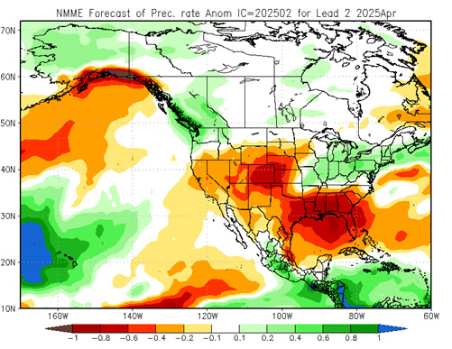
Figure 5. Modelled precipitation anomalies for the month of April from the NMME (average of all models weighted accordingly). Source: Climate Prediction Center.
When will fire season end?
The end of fire season is determined upon when the greenup of dormant vegetation exceeds the dead grasses and, thus, inhibits fire spread. This is a gradual process that typically initiates in southeast Kansas first and expands north/west depending on soil moisture, precipitation, temperature, and day length. After the very wet November, soil moisture profiles are doing well, with 80% or better saturation at the 20cm level (Figure 6). In fact, soil moisture is problematic for much of eastern Kansas with muddy conditions. This could result in stuck trucks during prescribed fires or wildfire response. Personnel should take extra precautions to ensure they avoid muddy locations on the fireground. This ample moisture should allow for a quick greenup over the coming weeks. While it won’t stop fire completely, it should help prevent spreading in shorter grass of yards as we go into April and hopefully mitigate some fire spread. As the moisture is utilized by vegetation, it will need to be restored by precipitation. With dry conditions expected this spring (and the potential expansion of drought), growth may slow later in spring and even stop altogether. This would result in the extension of fire season later into the spring than normal. Kansas can observe large fire activity into May, potentially into summer if drought conditions become extreme enough.
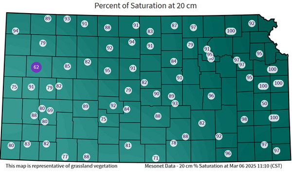
Figure 6. Kansas Mesonet soil moisture percent of saturation at the 20 cm (8 inches) depth. Higher values provide increased soil moisture content compared to 100% saturation. Data from the Kansas Mesonet: https://mesonet.k-state.edu/agriculture/soilmoist/.
Preparing for wildfires
Most fires in Kansas are caused by human activity. Debris burning, escaped prescribed burn, welding or cutting in dry grass, dragging chains, and defective equipment are examples of human-induced fires. Be especially cautious on any dry, breezy day – which is pretty common during spring in Kansas before green up.
Take steps to prepare your property to survive a fire - Clear brush from the house, keep gutters cleaned out, have non-combustible siding and roofing material, and more. In a major wildfire, the fire department will not have enough resources to protect every home or property, so those who can survive independently have the best chance. For more information, please refer to KSRE publication MF2241 Protecting your home from wildfire at https://bookstore.ksre.ksu.edu/pubs/MF2241.pdf.
More information on how to have a successful and safe prescribed burn will be available in an upcoming eUpdate.
The bottom line
After a below-average fire season in 2024 and a slow start to 2025, we anticipate conditions to align for a rapid increase in late March and April wildfires. With current climatic and fuel conditions, we are currently forecasting an average to above-average spring 2025 fire season. You can look at the fire danger forecast for the next five days on the Mesonet at: https://mesonet.k-state.edu/fire/danger/. Wildfires are a real risk for Kansans, even with recent moisture. People should have a plan and take proper precautions to avoid fire starts and limit fire spread.
Christopher “Chip” Redmond, Kansas Mesonet
christopherredmond@ksu.edu
Eric Ward, Assistant Fire Management Officer – Kansas Forest Service
eward@ksu.edu
Tags: safety wildfire fire weather