The start of 2024 has been quiet wildfire-wise across Kansas. However, as we have seen this week, fire season is here for the Central Plains. Take this opportunity to refresh your situational awareness resources and make preparations so you can be ready should there be a wildfire near you.
Last year’s rain helps drive fire season
Last year was an interesting year for wildfires with most occurring in late March and April. Overall, the fire season was near normal. There were not many large and/or disruptive wildfires like we had seen the previous year with the Four County, Starbuck, and Anderson Creek Fires. Despite growing drought in the Plains early season, timely moisture delayed fire season somewhat. As a result, fire season was mainly driven by copious prescribed fire escapes and driven by increased grass growth in the Flint Hills.
Precipitation in the preceding year is a deciding factor on how much grass growth (or fine fuels) we see across Kansas for the coming fire season. 2023 consisted of a rainfall pattern opposite to what we would climatologically expect for the region. The state's western portion saw above-normal precipitation during the spring and early summer. Meanwhile, drought continued to expand and worsen further east in central and east Kansas. The increased moisture led to above-normal grass growth (Figure 1) in the southwest and along the Oklahoma border. This is where fires could burn more aggressively and be much harder to suppress. Meanwhile, below-normal grass growth and fuel loading are expected in the north-central part of the state. Fires are still possible here, but the overall available fuel to burn is likely less than a normal year.
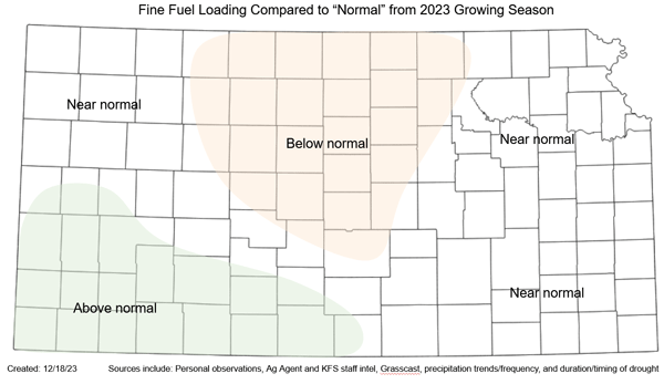
Figure 1. Areas of estimated above/below/at normal grass (or fuel) loading. Above-normal areas observed increased moisture during the growing season and have potentially more potential for increased fire behavior and large fire potential. The opposite is expected in the below-normal area. Estimates from numerous sources were also considered. Source: Kansas Forest Service and Kansas Mesonet.
Weather patterns play an important role
Contrary to popular belief, large wildfires in Kansas are usually independent of long-term drought conditions. Short-term weather drives fire potential in the state and determines the availability of grass to burn. This makes predicting a fire season challenging because one or two conducive days can skew an entire season. We see similar challenges to seasonal tornado predictions in Kansas.
Several weather events are responsible for the biggest wildfires in Kansas history. The most dangerous is what meteorologists call a “mid-latitude cyclone,” a low-pressure system that typically forms east of the Rocky Mountains and moves eastward across the Plains. These dynamic systems typically feature strong winds and drastic air masses separated by fronts as they spin counterclockwise around the center. Systems of this nature provide significant challenges with shifting winds that make firefighting dangerous and fire spread nearly impossible to suppress.
Mid-latitude cyclones are also often responsible for severe weather and even blizzards - all dependent on your location to the center of the low. The area between the dryline and cold front is most conducive for wildfires. Historical fires such as Four Corner, Starbuck, and Anderson Creek all developed in the shaded orange area of a low-pressure system (Figure 2).
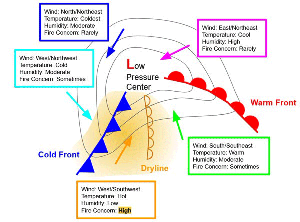
Figure 2. Diagram depicting a surface low-pressure system responsible for the most active weather on the Plains. Significant wildfires may develop south of the low pressure center between the dryline and the cold front.
Strong low-pressure systems are usually well forecasted at most one to two weeks in advance. Beyond that, we must consider whether upcoming patterns favor such systems. By looking at large-scale patterns across the globe, like the ENSO region and El Nino, we can usually get an idea of how frequent these events may be.
Looking to the future
Despite the two-week cold period in January 2023, winter 2023-2024 has been extremely warm. In fact, December and February (likely) are on the top five list of warmest Kansas months on record. The impressive warmth of February has taken a toll, with numerous records broken across the region. In addition, dry conditions during the last month (as of this writing, much of the state has gone 20+ days without 0.1 inches of moisture, https://mesonet.k-state.edu/precip/consecutive/) have offset the previous wet conditions. This has primed the Kansas landscape for wildfires. These conditions are fueled by an active weather pattern with prevalent winds that combine for a recipe for large fires.
Fortunately, the Climate Prediction Center (CPC) calls for above-normal moisture to be centered around a storm system on March 8th (give or take a day or two). With very potent fire weather conditions up to that event, the track of that storm system will determine who gets continued fire weather concerns into mid-March and who will get a much-needed moisture event that slows things down. Kansas fire season typically extends into April, and as we saw last year, we can have large fires into mid and even late that month. Any precipitation would just be a slowing event. Especially considering the amount of fire that is put down in the Flint Hills each March/April.
This winter has been characterized by an El Niño phase of the ENSO. This warmer water off the equatorial east Pacific region drives a stronger-than-normal jet stream into the southern United States. This has been the main contributor to warmer-than-normal temperatures and the above-normal moisture of December and January. It also tends to result in less large wildfire activity, with only about 500,000 acres burned during El Niño Springs. La Niña, the opposite (of which we have been in the previous three winters), tends to lead to much more wildfire activity, with an average of 1.5 million acres burned during those springs. Therefore, we typically expect less fire activity during an El Niño spring.
Shrinking the 2024 wildfire potential window
The conclusion of fire season is typically considered when cool season grasses green up and prevent fire spread. This varies by year and is primarily dependent on soil moisture and temperatures. Thus far in 2024, green up nationally is moving northward at (for the second year in a row) record pace and arriving up to a month early (Figure 3). With the current projection of temperatures and continued abundance of soil moisture (Figure 4), it is expected to continue to proceed rapidly. It is important to note that fires will still be possible; however, barriers to spread and smoke production will increase. Early green-up also increases the potential for late frost/freezes, which may damage wheat/grasses and make them able to burn later in spring.
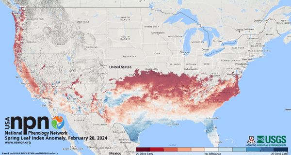
Figure 3. National Phenology Network Spring Leaf Index Anomaly as of February 28, 2024. Red areas represent where green up is occurring up to a month early.
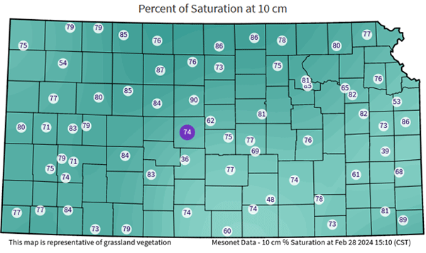
Figure 4. Kansas Mesonet soil moisture percent of saturation at the 10 cm (4 inches) depth. Higher values provide increased soil moisture content compared to 100% saturation. Data from the Kansas Mesonet: https://mesonet.k-state.edu/agriculture/soilmoist/.
Preparing for wildfires
Most fires in Kansas are caused by human activity. Debris burning, escaped prescribed burn, welding or cutting in dry grass, dragging chains, and defective equipment are examples of human-induced fires. Be especially cautious on any dry, breezy day – which is pretty common during spring in Kansas before green up.
Take steps to prepare your property to survive a fire - Clear brush from the house, keep gutters cleaned out, have non-combustible siding and roofing material, and more. In a major wildfire, the fire department will not have enough resources to protect every home or property, so those who can survive independently have the best chance. For more information, please refer to KSRE publication MF2241 Protecting your home from wildfire at https://bookstore.ksre.ksu.edu/pubs/MF2241.pdf.
More information on how to have a successful and safe prescribed burn will be available in an upcoming eUpdate.
The bottom line
Conditions into spring will become increasingly conducive for wildfires statewide until widespread moisture or green-up occurs. Overall, fire season is expected to be at/below average for March and April. You can monitor the forecasted fire danger on the Mesonet here: https://mesonet.k-state.edu/fire/danger/. Wildfires are a real risk for Kansans, even with recent moisture. People should have a plan and take proper precautions to avoid fire starts and limit fire spread.
Christopher "Chip" Redmond, Kansas Mesonet
christopherredmond@ksu.edu
Eric Ward, Assistant Fire Management Officer – Kansas Forest Service
eward@ksu.edu