Shorter days, longer nights, and cooler weather: these are all inevitable events that occur every fall. Another fall event is the first frost that marks the end of the growing season. Northwest Kansas typically observes the state’s first freeze in early October, but it has happened earlier during September. However, the first freeze is running behind schedule this year; it has yet to occur anywhere in the state as of October 15. The coldest temperature recorded by the Kansas Mesonet this fall is 39.8°F, recorded at the Sheridan County site near Seguin on October 8 (Figure 1). Most locations have dipped into the 40s at least once, but there are a few spots in southern Kansas that have yet to reach a temperature below 50. How unusual is this fall’s lack of chilly air?
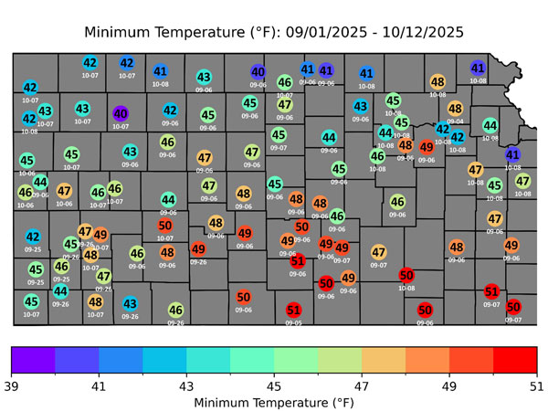
Figure 1. Coolest temperature recorded across the Kansas Mesonet this fall, through October 12th. Plotted dates indicate the date (in MM-YY format) that the coolest readings were observed.
Warm start to October
Figure 2 shows the average date of the first low in the 30s across Kansas. Most of the state should already have fallen into the 30s at least once by now. Instead, we have had an extended period of unseasonably warm weather. In the past five weeks, the average daily temperature across the Kansas Mesonet has been below normal just three times: September 18, and October 6 and 7.
The average temperature in Kansas for the first 15 days of October is 68.4°F, or 8.9° above normal. A few individual locations are more than 10° above normal (Figure 3). If we finish October at the current +8.9° departure, October 2025 will rank as the second warmest on record, behind only 1963. That year, the average monthly temperature was 65.5°, 9.3° above normal. In terms of departures, we are slightly behind 1963’s mark, but with respect to average temperature, we are nearly 3 degrees ahead of the current record.
It’s unlikely that October will finish at or above the current average temperature of 68.4°F, as we are in a period during which average temperatures are steadily decreasing, and highs in the 80s will become less likely with each passing day. The significance of an average temperature this warm is that the month of October has averaged at or above 60 degrees only ten times in 131 years, dating back to 1895 (Source: National Centers for Environmental Information). We are well above that mark now, so much so that the second half of October could cool down to near normal, and the month would still finish above the 60-degree mark. The question is how far above 60 we end up, and how high October 2025 will ultimately rank. It’s worth noting that October 2024 was also very warm. Last October was the fourth warmest on record, with an average temperature of 62.5°, a departure from normal of +6.3 degrees.
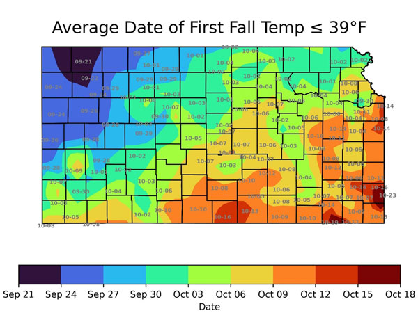
Figure 2. Average date of the first low temperature of 39 degrees or colder, based on data from 1991-2020. Plotted dates indicate the average date (in MM-YY format) at various locations around Kansas. (Data source: SC-ACIS)
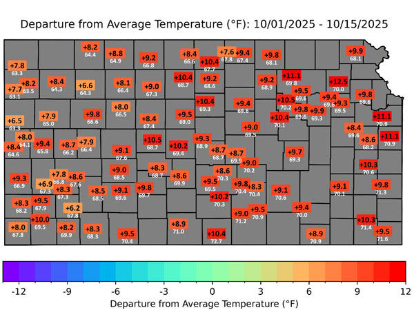
Figure 3. Departures from normal of average temperatures across the Kansas Mesonet for the period October 1-15, 2025. The white numbers below the rectangles are the average temperature for the same period.
How late is this year’s freeze?
A low in the upper 30s is not something to be concerned about, as frost is unlikely until temperatures fall into the mid-30s. A first freeze, on the other hand, is of greater concern as it typically signals the end of the growing season. Figure 4 shows the average date of the first freeze across Kansas. In far northwestern Kansas, the average date has already passed, and the region remains free of a freeze, along with the rest of the state. We are approaching the current record for the latest first freeze in Kansas.
In the Mesonet era, the latest first freeze was on October 22, 2008, when Colby (31.8°), Garden City (31.3°), and Tribune (29.7°) all fell below freezing for the first time that fall. We still have a few days to go to set a new record, but we’re already in 2nd place for the latest first freeze in the 40-year history of the Kansas Mesonet by virtue of having made it to October 15 without one. If you’re wondering when the earliest freeze was in Mesonet history, it happened five years ago. It was on September 8, 2020, and was by the narrowest of margins, when Wallace dipped to 31.9°. The next earliest freeze record is September 13, 2014.
At this point, it’s impossible to determine whether a few intrusions of colder air will be necessary to achieve a freeze at all locations or if one significant push of cold air will be sufficient. Some years, that first push of cold air is sufficiently chilly to plunge the entire state to below freezing, but it’s more common to see a freeze in the northwest first and in the southeast later in the fall.
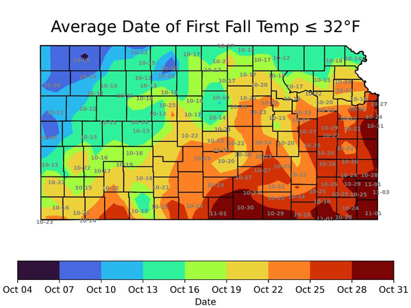
Figure 4. Average date of the first freeze, based on data from 1991-2020. Plotted dates indicate the average date (in MM-YY format) at various locations around Kansas. (Data source: SC-ACIS)
Comparing to previous years
In 2024, the first fall freeze was on October 4 at the Cheyenne County site southwest of St. Francis. Most locations recorded a freeze by mid-month, with temperatures as low as 18° at the Phillipsburg Mesonet site on the morning of October 16. The average low that morning across the state was 27°. It warmed up after that, and it was another four weeks before the second sub-freezing average low occurred (30° on November 14). Even then, it took until November 21 for every site to record its first freeze (Corning and Konza Prairie were the last holdouts). The takeaway is that an above-normal month doesn’t always mean a late freeze.
Looking ahead
There is no way to know at this point exactly how this fall will play out in terms of first and last freezes, but in the short term, the 8- to 14-day outlook favors above-normal temperatures statewide (Figure 5). It appears that we will approach that record late date and possibly set a new record, but there will be a cooldown this coming weekend, and parts of northwest Kansas have a chance of falling close to freezing. A first frost is a possibility in these areas. Even if this happens, it may not be until November before everyone sees a freeze, similar to what happened last year.
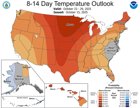
Figure 5. The Climate Prediction Center’s 8 to 14-day temperature outlook, valid for the period October 21-25.
Matthew Sittel, Assistant State Climatologist
msittel@ksu.edu
Tags: weather climate first freeze