Meteorological spring began on March 1. Since that date, the last two months have featured a sharp contrast in precipitation amounts across Kansas. In the east, precipitation has been plentiful, particularly in the past month. Meanwhile, southwest Kansas has seen very little in the way of moisture. As a result, drought conditions have improved or maintained the status quo in the wetter areas but have notably worsened in the state's driest parts. In this report, we take a closer look at where precipitation totals and drought conditions stand across Kansas through the first two months of spring.
Bourbon County is the precipitation “winner” so far this spring (Table 1, Figure 1). The CoCoRaHS observer in Devon, northwest of Fort Scott, has recorded the most precipitation in the state: 16.58” since March 1. Of that total, 13.71” fell in April. Devon's two highest daily amounts occurred just this past week: 6.88” on April 28th and 3.82” on April 26th. Extreme as the 6.88” amount is, there were even higher amounts on the 28th. The maximum 1-day total was 8.10” in Humboldt (Allen County, COOP observer). This amount is historic; in the 42-year history of the Humboldt site, this is their highest single-day precipitation total on record. Close behind was 7.94” in Wilson County, a CoCoRaHS report from north-northeast of Altoona. Amounts over 7” were also recorded by CoCoRaHS observers in Neosho (7.37” in Erie), Cowley (7.34” south-southeast of Dexter) and Bourbon (7.32” in Fort Scott) Counties, and by co-operative observers in Wilson (7.43”, Neodesha 3NE) and Allen (7.28”, Moran) Counties. These extreme totals resulted from multiple rounds of thunderstorms training over the same areas, the second of two heavy rain events in the past week. Severe weather accompanied these storms, including tornadoes, large hail, and high winds.
Table 1. Highest precipitation amounts across Kansas since March 1.
|
Location |
Network |
County |
Amount (in.) |
|
Devon 0.1 SE |
CoCoRaHS |
Bourbon |
16.58 |
|
Fort Scott 0.6 SW |
CoCoRaHS |
Bourbon |
15.13 |
|
Humboldt |
COOP |
Allen |
15.01 |
|
Fort Scott 9.3 NNE |
CoCoRaHS |
Bourbon |
14.97 |
|
Mound City 1SSW |
COOP |
Linn |
14.80 |
|
Moran |
COOP |
Allen |
14.34 |
|
Fort Scott 0.6 W |
CoCoRaHS |
Bourbon |
14.22 |
|
Savonburg 4.1 ESE |
CoCoRaHS |
Bourbon |
14.01 |
|
Longton |
COOP |
Elk |
13.63 |
|
Colony |
COOP |
Anderson |
13.40 |
|
Altoona 7.2 NNE |
CoCoRaHS |
Wilson |
13.08 |
|
Erie 0.4 NNW |
CoCoRaHS |
Neosho |
12.72 |
|
Neodesha 3NE |
COOP |
Wilson |
12.50 |
|
Iola 2.7 SSE |
CoCoRaHS |
Allen |
12.36 |
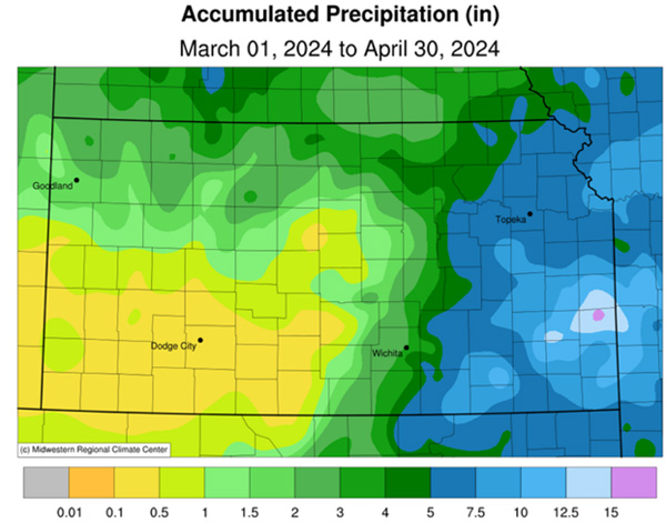
Figure 1. Total precipitation across Kansas since March 1, 2024. Source: Midwest Regional Climate Center (mrcc.purdue.edu).
On the dry side, many locations in southwest Kansas have had less than half an inch of precipitation since March 1. The lowest total in the state is in Gray County, where a CoCoRaHS observer in Montezuma has measured only a trace of precipitation since March 1 (Table 2). It fell on April 20, the first precipitation since a trace was reported back on February 18th, 62 days earlier. The last time measurable precipitation fell there was on February 12, when 0.01” was recorded. Parts of Meade and Ford Counties have also had less than one-tenth of an inch of precipitation. It's important also to consider the departures from normal precipitation that has fallen in the state (Figure 2). While there are some areas of above-normal precipitation in eastern Kansas, the majority of the state has had below-normal precipitation since March 1st. The most below-normal areas in Kansas are not in southwest Kansas, where the lowest totals are, but in south-central Kansas. Parts of this division are more than 4 inches below normal since March 1. The result of these deficits is evident on the US Drought Monitor change map (Figure 3), where three-category degradations have occurred in parts of south central and southwest Kansas. As of April 30, 27% of Kansas is in D2 status (Figure 4). This is the largest amount in almost five months. Fortunately, no areas are in D3 or worse status yet. If precipitation continues to miss the parched areas in the southwest in the coming weeks, worsening conditions are likely. The recent heavy rains in southeast Kansas have resulted in this area having better drought conditions than two months ago, with 16% of the state now drought-free.
Table 2. Lowest precipitation amounts across Kansas since March 1.
|
Location |
Network |
County |
Amount (in.) |
|
Montezuma 0.2 SE |
CoCoRaHS |
Gray |
Trace |
|
Meade 12.4 NW |
CoCoRaHS |
Meade |
0.05 |
|
Montezuma |
COOP |
Gray |
0.07 |
|
Bucklin 0.2 N |
CoCoRaHS |
Ford |
0.08 |
|
Spearville 5.4 SW |
CoCoRaHS |
Ford |
0.08 |
|
Dodge City 9.1 WNW |
CoCoRaHS |
Ford |
0.09 |
|
Pratt 3.1 N |
CoCoRaHS |
Pratt |
0.09 |
|
Dodge City 11.0 SSE |
CoCoRaHS |
Ford |
0.09 |
|
Syracuse 19 NNW |
CoCoRaHS |
Hamilton |
0.10 |
|
Greensburg 8.7 SSW |
CoCoRaHS |
Kiowa |
0.14 |
|
Haviland 7.4 WNW |
CoCoRaHS |
Kiowa |
0.15 |
|
Jetmore 14.9 WSW |
CoCoRaHS |
Hodgeman |
0.15 |
|
Wilson 2.8 W |
CoCoRaHS |
Russell |
0.15 |
|
Garden City Airport |
WBAN |
Finney |
0.17 |
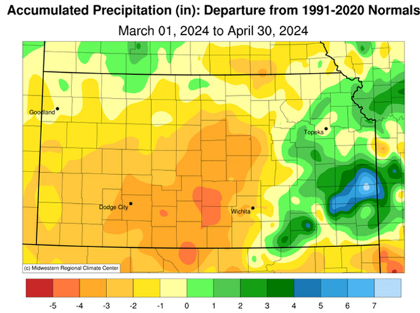
Figure 2. Departure from normal precipitation across Kansas since March 1, 2024. Source: Midwest Regional Climate Center (mrcc.purdue.edu).
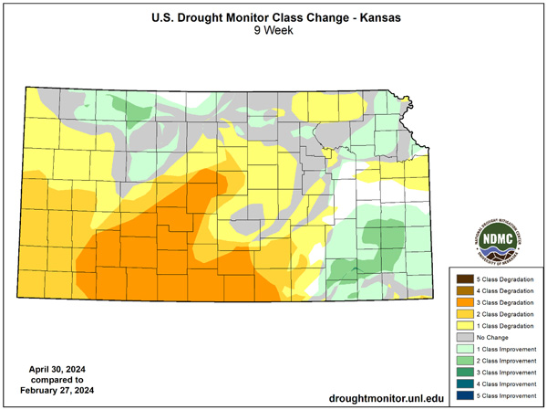
Figure 3. Change in the US Drought Monitor category across Kansas since February 27, 2024. Source: droughtmonitor.unl.edu.
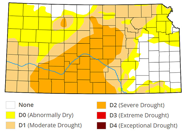
Figure 4. US Drought Monitor category map for Kansas as of April 30, 2024. Source: droughtmonitor.unl.edu.
The good news is that we are entering what are traditionally the wettest months of the year in Kansas. Depending on location, from 43 to 63% of annual precipitation falls on average between May 1 and August 31 (source: National Centers for Environmental Information). Every part of the state averages at least 10 inches of precipitation during this 4-month period. We’re entering “prime time” for heavy rainfall and also for severe weather. Rainfall totals in the past week are potentially a sneak preview of what’s yet to come. A companion article in this eUpdate goes into more detail about the weather outlook for Kansas in the coming weeks.
Matthew Sittel, Assistant State Climatologist
msittel@ksu.edu
Tags: spring precipitation rainfall