A Thanksgiving weekend snowstorm brought accumulating snow to most of the state. The highest totals were in central Kansas, where over a foot of snow was measured in a few locations (Table 1). In some places, this was the most snow from a single event in nearly a decade. In addition, the snow from this single event totaled more than what fell last season in some spots.
Table 1. Snowfall totals for select locations around the state. These reports are from the public, which includes cooperative and CoCoRaHS observers.
|
Location |
County |
Amount |
Location |
County |
Amount |
|
Marion |
Marion |
14.1 |
Eureka 0.9 NW |
Greenwood |
8.1 |
|
Burns |
Marion |
13.0 |
Coldwater |
Comanche |
8.0 |
|
Council Grove 0.3 N |
Morris |
12.0 |
Eskridge 0.1 SW |
Wabaunsee |
8.0 |
|
Hutchinson 3 ESE |
Reno |
12.0 |
Assaria 6.2 SE |
Saline |
7.8 |
|
Preston 6 NW |
Stafford |
10.5 |
Greensburg |
Kiowa |
7.3 |
|
Lyons |
Rice |
10.0 |
Wamego 1.3 W |
Pottawatomie |
7.0 |
|
Byers |
Pratt |
9.5 |
Belle Plaine 2.8 W |
Sumner |
7.0 |
|
Americus |
Lyon |
9.0 |
Offerle 9.8 S |
Edwards |
6.7 |
|
Hope |
Dickinson |
9.0 |
Lawrence 9.2 WNW |
Douglas |
6.5 |
|
Cottonwood Falls |
Chase |
8.5 |
Junction City |
Geary |
6.5 |
The event began early on Friday, the 24th, with an area of snow that moved out of eastern Colorado into northwest Kansas. The highest snow totals were in Decatur, Rawlins, and Thomas Counties. A CoCoRaHS observer south of Oberlin measured 4.5 inches of snow, the highest total from the first round of snow. By early Saturday, another area of snow had developed in southwest Kansas, and by 7 AM CST, totals from 1 up to 3.5 inches had already fallen in Ford, Clark, Meade, and Seward Counties. The main event was later on the 25th, as this area of snow increased in coverage over south central Kansas during the daylight hours and intensified as it moved east and northeast. Snow was the predominant precipitation type across central and northeast Kansas. Still, with warmer temperatures in southeast Kansas, rain was observed during the day, with a transition to snow overnight as colder air arrived. A few areas of freezing rain were reported in the evening in the Winfield and Chanute areas. By early Sunday morning, snow had exited the state and moved into western Missouri, leaving treacherous road conditions in its wake for those returning home from Thanksgiving travels.
South central and central Kansas had the highest snowfall totals from this event (Figure 1), where over a foot of snow fell in parts of Reno, Harvey, Marion, and Morris Counties. There were two reports of 14 inches of snow in Marion County, the highest amount in the state. There were reports of 6 to 8 inches of snow in the Wichita, Manhattan, Topeka, and Lawrence areas and 4 to 6 inches in the Dodge City and Salina areas. The Kansas City metropolitan area picked up from 2 to 4 inches. In at least a dozen locations, the snowfall from this event was more than what fell during the entire winter of 2022-23 (Table 2).
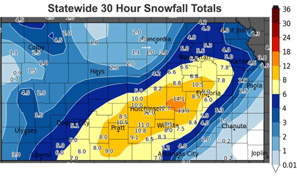
Figure 1. Snowfall totals from the Thanksgiving weekend storm. Source: National Weather Service-Wichita, KS Facebook page.
Table 2. A partial list of locations where this past weekend’s snowfall exceeded the total for all of last season.
|
Location |
County |
Total Snowfall (inches) |
|
|
Nov. 25-26, 2023 |
Jul. 1, 2022-Jun. 30, 2023 |
||
|
Hesston |
Harvey |
12.7 |
2.4 |
|
Kingman |
Kingman |
10.8” |
4.2 |
|
Sterling |
Rice |
9.0 |
7.8 |
|
Newton |
Harvey |
8.2 |
5.1 |
|
McPherson |
McPherson |
8.0 |
6.0 |
|
Osage City |
Osage |
8.0 |
5.2 |
|
Wichita |
Sedgwick |
7.8 |
5.0 |
|
Topeka |
Shawnee |
7.2 |
6.1 |
|
Ashland |
Clark |
7.0 |
1.2 |
|
Manhattan |
Riley |
6.0 |
3.3 |
|
El Dorado |
Butler |
6.0 |
3.0 |
|
Anthony |
Harper |
4.5 |
4.0 |
Historically, this was a significant snow event (Table 3). While heavy snow is not unprecedented in November, it is certainly unusual. Average snowfall during November is only around half an inch in the southeast, one to two inches in central Kansas, and from 2 to 3.5 inches in northwest Kansas (Table 4). The totals from this recent event exceed the monthly averages in many areas. If we take a closer look at historical snowfall data at some of Kansas’ long-term climate sites, the significance of this event becomes apparent. The snow totals from this single event ensure that November 2023 will rank in the top 10 snowiest Novembers on record in Wichita, Topeka, Manhattan, and Dodge City. This was also the most snow from a single storm in nearly ten years at Wichita (7.8 inches), Topeka (7.2 inches), and Manhattan (6.0 inches), the most since a snowstorm on February 4-5, 2014, dumped between 8 to 14 inches of snow in these areas.
Table 3. Comparison of November 2023’s snow to historical totals at long-term climate sites. All amounts are reported as inches.
|
Location |
Wichita |
Topeka |
Manhattan |
Dodge City |
|
Nov. 2023 Snowfall |
7.8 |
7.2 |
6.0 |
5.3 |
|
Normal Nov. Snowfall |
0.8 |
1.0 |
1.1 |
1.4 |
|
Nov. 2023 Snowiest Rank / # Years in Record |
4 / 135 |
6 / 137 |
5 / 127 |
10 / 131 |
|
Last Nov. with More Snow (Amount) |
1951 (8.1) |
2018 (8.0) |
2018 (7.2) |
2004 (8.5) |
|
Snowiest Nov. on Record (Amount) |
1888 (9.0) |
1888 (9.8) |
1975 (8.8) |
1929 (16.8) |
|
Normal Seasonal Snowfall |
12.7 |
17.1 |
17.6 |
19.1 |
|
Last Nov. Storm with More Snowfall (Amount) |
Nov. 9-11, 1906 (8.7) |
Nov. 25-26, 1975 (8.1) |
Nov. 26, 1975 (7.8) |
Nov. 28-30, 2004 (6.0) |
|
Last Storm with More Snowfall (Amount) |
Feb. 4, 2014 (8.7”) |
Feb. 4-5, 2014 (13.0”) |
Feb. 4-5, 2014 (14.0”) |
Jan. 21, 2023 (7.4”) |
Table 4. Monthly snowfall averages (in inches) for select locations in Kansas.
|
Region |
City |
Sep |
Oct |
Nov |
Dec |
Jan |
Feb |
Mar |
Apr |
May |
Total |
|
Northwest |
Colby |
0.2 |
1.6 |
3.5 |
3.9 |
5.1 |
5.8 |
4.2 |
2.2 |
0.7 |
27.2 |
|
Goodland |
0.2 |
2.0 |
3.3 |
5.2 |
4.7 |
6.3 |
4.8 |
3.2 |
0.3 |
30.0 |
|
|
Hill City |
0.0 |
0.7 |
1.5 |
3.8 |
3.3 |
5.5 |
2.1 |
0.3 |
0.2 |
17.4 |
|
|
Oberlin |
0.0 |
1.3 |
2.3 |
4.2 |
5.7 |
6.2 |
3.4 |
1.9 |
0.2 |
25.2 |
|
|
St. Francis |
0.3 |
0.9 |
2.0 |
2.9 |
4.6 |
4.5 |
2.9 |
1.7 |
0.0 |
19.8 |
|
|
North Central |
Cawker City |
0.0 |
0.3 |
1.6 |
3.5 |
4.5 |
5.8 |
1.7 |
0.5 |
0.0 |
17.9 |
|
Concordia |
0.0 |
0.3 |
1.9 |
4.5 |
5.4 |
5.2 |
1.6 |
0.4 |
0.0 |
19.3 |
|
|
Minneapolis |
0.0 |
0.3 |
1.6 |
4.5 |
4.7 |
3.4 |
2.2 |
0.9 |
0.0 |
17.6 |
|
|
Phillipsburg |
0.0 |
0.7 |
1.1 |
3.2 |
3.4 |
6.6 |
1.5 |
0.5 |
0.0 |
17.0 |
|
|
Washington |
0.0 |
0.1 |
1.0 |
2.4 |
4.6 |
4.6 |
1.4 |
0.3 |
0.0 |
14.4 |
|
|
Northeast |
Atchison |
0.0 |
0.3 |
0.9 |
3.8 |
5.0 |
4.8 |
1.8 |
0.4 |
0.0 |
17.0 |
|
Bonner Springs |
0.0 |
0.3 |
1.1 |
4.3 |
5.0 |
5.1 |
1.5 |
0.1 |
0.0 |
17.4 |
|
|
Hiawatha |
0.0 |
0.0 |
1.2 |
3.6 |
4.7 |
4.1 |
2.2 |
1.1 |
0.0 |
16.9 |
|
|
Manhattan |
0.0 |
0.0 |
1.1 |
4.8 |
4.8 |
5.0 |
1.8 |
0.1 |
0.0 |
17.6 |
|
|
Marysville |
0.0 |
0.1 |
1.0 |
3.3 |
4.9 |
4.3 |
1.5 |
0.7 |
0.0 |
15.8 |
|
|
West Central |
Ness City |
0.0 |
0.4 |
1.3 |
3.2 |
3.2 |
3.5 |
3.3 |
0.4 |
0.1 |
15.4 |
|
Oakley |
0.0 |
1.2 |
2.5 |
4.5 |
4.5 |
6.6 |
4.2 |
1.8 |
0.4 |
25.7 |
|
|
Scott City |
0.0 |
1.2 |
1.1 |
3.1 |
4.5 |
4.0 |
3.9 |
1.8 |
0.0 |
19.6 |
|
|
Tribune |
0.1 |
1.3 |
2.1 |
3.8 |
4.2 |
4.2 |
3.6 |
2.1 |
0.3 |
21.7 |
|
|
WaKeeney |
0.0 |
1.1 |
1.8 |
4.3 |
4.3 |
4.3 |
3.2 |
1.3 |
0.0 |
20.3 |
|
|
Central |
Abilene |
0.0 |
0.2 |
1.0 |
2.2 |
4.1 |
2.8 |
1.7 |
0.2 |
0.0 |
12.2 |
|
Great Bend |
0.0 |
0.1 |
1.7 |
2.3 |
2.2 |
2.6 |
2.3 |
0.3 |
0.0 |
11.5 |
|
|
Hays |
0.0 |
0.3 |
1.4 |
3.3 |
3.4 |
4.8 |
2.1 |
0.5 |
0.0 |
15.8 |
|
|
McPherson |
0.0 |
0.1 |
0.6 |
2.9 |
4.1 |
3.3 |
2.6 |
0.6 |
0.0 |
14.2 |
|
|
Salina |
0.0 |
0.5 |
1.4 |
4.1 |
3.8 |
4.0 |
1.3 |
0.4 |
0.0 |
15.5 |
|
|
East Central |
Council Grove |
0.0 |
0.4 |
0.5 |
2.8 |
4.0 |
2.9 |
1.2 |
0.2 |
0.0 |
12.0 |
|
Emporia |
0.0 |
0.1 |
1.4 |
3.9 |
5.5 |
4.1 |
1.0 |
0.3 |
0.0 |
16.3 |
|
|
Garnett |
0.0 |
0.5 |
0.4 |
3.0 |
4.8 |
2.5 |
1.4 |
0.2 |
0.0 |
12.8 |
|
|
Olathe |
0.0 |
0.3 |
1.2 |
3.4 |
3.9 |
3.3 |
1.4 |
0.3 |
0.0 |
13.8 |
|
|
Topeka |
0.0 |
0.4 |
1.0 |
4.1 |
4.6 |
5.2 |
1.7 |
0.1 |
0.0 |
17.1 |
|
|
Southwest |
Ashland |
0.0 |
0.1 |
0.5 |
3.2 |
2.3 |
3.6 |
1.8 |
0.1 |
0.0 |
11.6 |
|
Dodge City |
0.0 |
0.6 |
1.4 |
4.0 |
3.9 |
4.7 |
3.7 |
0.8 |
0.0 |
19.1 |
|
|
Elkhart |
0.0 |
0.7 |
1.2 |
4.7 |
4.2 |
2.1 |
3.5 |
0.4 |
0.8 |
17.6 |
|
|
Garden City |
0.0 |
0.8 |
1.0 |
2.7 |
3.4 |
3.3 |
3.2 |
1.1 |
0.1 |
15.6 |
|
|
Liberal |
0.0 |
0.7 |
1.0 |
4.6 |
3.5 |
1.8 |
2.3 |
0.4 |
0.1 |
14.4 |
|
|
South Central |
Greensburg |
0.0 |
0.4 |
1.4 |
3.6 |
4.5 |
2.6 |
3.8 |
0.0 |
0.0 |
16.3 |
|
Hutchinson |
0.0 |
0.0 |
0.7 |
3.1 |
3.5 |
1.9 |
2.3 |
0.3 |
0.0 |
11.8 |
|
|
Medicine Lodge |
0.0 |
0.0 |
0.3 |
2.1 |
2.1 |
4.0 |
0.8 |
0.1 |
0.0 |
9.4 |
|
|
Pratt |
0.0 |
0.1 |
0.4 |
2.6 |
3.6 |
3.9 |
4.1 |
0.4 |
0.0 |
15.1 |
|
|
Wichita |
0.0 |
0.2 |
0.8 |
3.1 |
2.7 |
3.6 |
2.1 |
0.2 |
0.0 |
12.7 |
|
|
Southeast |
Arkansas City |
0.0 |
0.0 |
0.2 |
1.9 |
1.8 |
1.1 |
1.1 |
0.1 |
0.0 |
6.2 |
|
Coffeyville |
0.0 |
0.0 |
0.6 |
3.2 |
1.8 |
1.4 |
1.3 |
0.0 |
0.0 |
8.3 |
|
|
Eureka |
0.0 |
0.1 |
0.5 |
3.0 |
2.8 |
1.2 |
0.9 |
0.1 |
0.0 |
8.6 |
|
|
Fort Scott |
0.0 |
0.0 |
0.4 |
2.3 |
3.9 |
1.0 |
0.7 |
0.1 |
0.0 |
8.4 |
|
|
Pittsburg |
0.0 |
0.0 |
0.6 |
2.9 |
3.4 |
1.0 |
1.6 |
0.0 |
0.0 |
9.5 |
The last time Wichita had this much snow in November was over 70 years ago, in 1951, but more noteworthy, the last time Wichita received more snow from a single storm in November was over a century ago, in 1906. This was the largest November snow event in Topeka and Manhattan since 1975. Wichita’s one-day snow total of 7.8 inches on the 25th was rare in two additional ways. It was the second snowiest November day on record in Wichita, behind only an 8.7 inches total on November 9, 1888. It also ranks as the 14th snowiest day in any month since weather records began in Wichita in September 1888.
Was this the first event in what may prove to be a snowy winter in Kansas? Time will tell; stay tuned!
Matthew Sittel, Assistant State Climatologist
msittel@ksu.edu
Tags: winter weather snow weather climate