A storm system brought significant precipitation to much of southwest Kansas last week. Most of the precipitation fell as rain, but with temperatures in the 30s during much of the event, some freezing rain was noted, especially early in the event on Dec. 13. A tenth of an inch of ice was reported in Gove County, with a thin glaze of ice noted in a few locations, including at Colby, Goodland, Hoxie, Leoti and Tribune. Snow fell in some areas, particularly on the northern fringes of the precipitation shield. The highest measured snow total was 4 inches in northern Wallace County, 3.3 inches in Tribune, and 1 to 3 inches in Sherman County, including the Goodland area. Later, snow mixed in at times further south as heavier precipitation increased the layer of cold air aloft, allowing precipitation to remain frozen all the way to the surface. Both Garden City and Dodge City reported periods of snow before precipitation changed back to rain.
Precipitation lasted into early on the 15th. Storm totals exceeded 3 inches in some areas (Figure 1, Table 1). The highest total was 3.59 inches, reported by a CoCoRaHS observer in southern Meade County. Reports of over 3 inches also came from Seward, Clark, Ford, and Edwards Counties. In most areas, the bulk of the precipitation fell on the 14th and was reflected in the 24-hour totals from the morning of the 15th (Table 2). The highest 24-hour total was in Clark County, where the cooperative observer in Ashland picked up 2.30 inches. Not far behind was a 2.24 inches report near Bucklin, in Ford County. The Bucklin total was historic, as it was the largest 24-hour amount ever recorded in the month of December at that location, where records date back 130 years. At least ten locations recorded a top 5 wettest December day during this event, including Dodge City, Greensburg, Hays, and Russell.
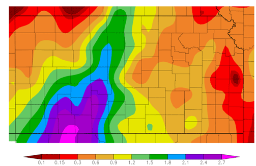
Figure 1. 7-day precipitation totals for the period Dec. 11-17, 2023. Source: HPRCC.
Table 1. The highest storm total precipitation amounts from selected counties across Kansas. Totals are in decreasing order and are based on totals for the period December 13-16, 2023.
|
Location |
Network |
County |
Total (inches) |
|
Meade 15.5 SSE |
CoCoRaHS |
Meade |
3.59 |
|
Minneola 4.1 SSE |
CoCoRaHS |
Clark |
3.49 |
|
Satanta |
Mesonet |
Seward |
3.12 |
|
Bucklin 0.1 SE |
CoCoRaHS |
Ford |
3.02 |
|
Lewis 3.8 W |
CoCoRaHS |
Edwards |
3.00 |
|
Ingalls 6.9 SW |
CoCoRaHS |
Gray |
2.67 |
|
Mullinville 5.7 NNW |
CoCoRaHS |
Kiowa |
2.66 |
|
Kalvesta 12.1 NNW |
CoCoRaHS |
Finney |
2.43 |
|
Sublette 0.6 WSW |
CoCoRaHS |
Haskell |
2.43 |
|
Coldwater 6.7 NW |
CoCoRaHS |
Comanche |
2.41 |
|
Jetmore 11.5 WNW |
CoCoRaHS |
Hodgeman |
2.38 |
|
Timken 7.8 SSW |
CoCoRaHS |
Rush |
2.27 |
|
Hugoton 0.6 NNW |
CoCoRaHS |
Stevens |
2.26 |
|
Burdett 3S |
COOP |
Pawnee |
2.20 |
|
Russell 0.1 E |
CoCoRaHS |
Russell |
2.17 |
|
Sublette 1E |
Mesonet |
Haskell |
2.12 |
|
Victoria 0.1 ESE |
CoCoRaHS |
Ellis |
2.01 |
|
Galatia 4.6 E |
CoCoRaHS |
Barton |
1.93 |
|
Utica 0.0 E |
CoCoRaHS |
Ness |
1.90 |
|
Hays |
COOP |
Ellis |
1.80 |
|
Natoma 6.7 NNE |
CoCoRaHS |
Osborne |
1.76 |
|
Sylvan Grove 5 NNW |
COOP |
Lincoln |
1.76 |
|
Smith Center |
COOP |
Smith |
1.70 |
|
Ulysses 13.0 ENE |
CoCoRaHS |
Grant |
1.68 |
|
La Crosse |
Mesonet |
Rush |
1.68 |
|
Syracuse 14.4 SSW |
CoCoRaHS |
Hamilton |
1.65 |
|
Plainville 4 WNW |
COOP |
Rooks |
1.62 |
|
Ionia |
COOP |
Jewell |
1.53 |
|
Holyrood 4.8 N |
CoCoRaHS |
Ellsworth |
1.50 |
Table 2. Records for the 24-hour period ending midnight or 7 AM on December 15, 2023. The 24-hour period at WBAN sites ends at midnight, while the 24-hour period at COOP sites ends at 7 AM. WBAN stands for Weather Bureau, Air Force, and Navy, which refers today to any observation provided and measured by a government agency. COOP refers to a cooperative citizen observer. T in the rankings refers to a tie.
|
Location |
Network |
County |
12/15 Precip. (in.) |
12/15 Rank Most 1-day Dec. Precip. |
Year Records Began |
Record Highest 1-day Precip. in Dec. |
|
|
Amt. |
Date |
||||||
|
Ashland |
COOP |
Clark |
2.30 |
3rd |
1900 |
2.98 |
12/30/2006 |
|
Bucklin 1SE |
COOP |
Ford |
2.24 |
1st |
1893 |
2.24 |
12/15/2023 |
|
Offerle 5S |
COOP |
Edwards |
1.85 |
2nd |
1973 |
1.85 |
12/30/2006 |
|
Dodge City |
WBAN |
Ford |
1.76 |
3rd |
1874 |
2.43 |
12/29/2006 |
|
Greensburg |
COOP |
Kiowa |
1.76 |
2nd |
1893 |
1.87 |
12/27/2018 |
|
Hays |
COOP |
Ellis |
1.71 |
2nd |
1952 |
1.83 |
12/28/2019 |
|
Coldwater |
COOP |
Comanche |
1.60 |
7th |
1893 |
2.52 |
12/11/2007 |
|
Burdett 3S |
COOP |
Pawnee |
1.60 |
3rd |
1941 |
1.67 |
12/30/2006 |
|
Caldwell |
COOP |
Sumner |
1.34 |
T 7th |
1940 |
2.64 |
12/20/2011 |
|
Cimarron |
COOP |
Gray |
1.28 |
8th |
1911 |
2.60 |
12/30/2006 |
|
Russell |
WBAN |
Russell |
1.26 |
3rd |
1949 |
1.78 |
12/13/2015 |
|
Smith Center |
COOP |
Smith |
1.18 |
9th |
1910 |
1.78 |
12/18/1918 |
|
Kingman |
COOP |
Kingman |
1.12 |
15th |
1907 |
2.58 |
12/27/2018 |
|
Plainville 4WNW |
COOP |
Rooks |
1.03 |
9th |
1893 |
2.70 |
12/14/2015 |
|
Utica |
COOP |
Ness |
1.02 |
10th |
1916 |
2.78 |
12/30/2006 |
|
Bluff City |
COOP |
Harper |
0.95 |
9th |
1973 |
1.45 |
12/27/2018 |
|
Ionia |
COOP |
Jewell |
0.93 |
9th |
1894 |
1.77 |
12/14/2015 |
|
Cedar Bluff Dam |
COOP |
Trego |
0.89 |
5th |
1949 |
2.37 |
12/30/2006 |
|
Hill City |
WBAN |
Graham |
0.78 |
13th |
1907 |
2.17 |
12/29/2006 |
|
Garden City |
WBAN |
Finney |
0.70 |
18th |
1893 |
2.27 |
12/29/2006 |
In at least fifteen locations, the totals from this event, when added to the first twelve days of the month, are enough to ensure a top 20 wettest December (Table 3), even if no additional precipitation falls for the rest of the month. At about half those locations, a top 10 wettest December is guaranteed. One of those locations is Smith Center, which had comparatively less precipitation than further south and west, but their 1.70 inches total is still good enough to secure at least a 9th wettest December. With two weeks left in this month, the final monthly totals may increase further, and more locations could finish in the top 10. The 7-day precipitation outlook calls for at least half an inch of precipitation for most of the state by Christmas morning, with totals over an inch possible in southeastern Kansas (Figure 2).
Table 3. December 2023 precipitation data at selected long-term climate sites in Kansas. POR refers to the period of record, the total number of available years of climate data at a given recording site. All precipitation amounts are reported as inches.
|
Location |
County |
Dec. 13-16 Storm Total |
Dec. 1-12 Precip |
Dec. ‘23 Precip. to Date (1st-16th) |
Dec. ‘23 Precip. to Date Rank/POR |
Most Precip. in Dec. |
Normal Dec. Precip. |
|
|
Amt. |
Year |
|||||||
|
Ashland |
Clark |
2.92 |
0.11 |
3.03 |
5 / 124 |
4.59 |
2006 |
1.00 |
|
Bucklin 1SE |
Ford |
2.84 |
0.16 |
3.00 |
4 / 103 |
4.16 |
2006 |
1.04 |
|
Cedar Bluff Dam |
Trego |
1.17 |
0.00 |
1.17 |
12 / 72 |
4.60 |
2006 |
0.80 |
|
Cimarron |
Gray |
2.22 |
0.00 |
2.22 |
6 / 113 |
5.35 |
2006 |
0.90 |
|
Coldwater |
Comanche |
2.01 |
0.30 |
2.31 |
T11 / 120 |
4.19 |
2007 |
1.12 |
|
Concordia |
Cloud |
0.77 |
0.05 |
0.82 |
51 / 139 |
3.91 |
2013 |
1.04 |
|
Dodge City |
Ford |
2.00 |
Trace |
2.00 |
10 / 150 |
4.36 |
1877 |
0.96 |
|
El Dorado |
Butler |
0.74 |
0.65 |
1.39 |
45 / 124 |
5.04 |
1984 |
1.30 |
|
Emporia |
Lyon |
0.86 |
0.08 |
0.94 |
26 / 56 |
3.10 |
2011 |
1.30 |
|
Garden City |
Finney |
1.52 |
0.00 |
1.52 |
10 / 123 |
4.97 |
2006 |
0.56 |
|
Goodland |
Sherman |
0.48 |
0.00 |
0.48 |
37 / 117 |
2.90 |
1924 |
0.47 |
|
Greensburg |
Kiowa |
2.30 |
0.49 |
2.79 |
4 / 115 |
4.21 |
1918 |
0.96 |
|
Hays |
Ellis |
1.80 |
0.00 |
1.80 |
13 / 130 |
3.11 |
1913 |
0.76 |
|
Hill City |
Graham |
0.83 |
Trace |
0.83 |
20 / 99 |
4.80 |
1913 |
0.66 |
|
Kingman |
Kingman |
1.29 |
0.36 |
1.65 |
T20 / 95 |
3.62 |
1943 |
1.29 |
|
Manhattan |
Riley |
0.62 |
0.19 |
0.81 |
62 / 131 |
3.84 |
1913 |
1.19 |
|
Medicine Lodge |
Barber |
1.12 |
0.01 |
1.13 |
34 / 126 |
3.98 |
1984 |
1.09 |
|
Plainville 4WNW |
Rooks |
1.62 |
Trace |
1.62 |
T15 / 112 |
3.91 |
2006 |
0.95 |
|
Russell |
Russell |
1.75 |
0.01 |
1.76 |
8 / 72 |
3.20 |
1984 |
0.74 |
|
Sedan |
Chautauqua |
0.87 |
0.74 |
1.61 |
53 / 131 |
5.41 |
1895 |
1.86 |
|
Smith Center |
Smith |
1.70 |
0.00 |
1.70 |
9 / 114 |
4.69 |
1913 |
0.79 |
|
Topeka |
Shawnee |
0.86 |
0.16 |
1.02 |
72 / 137 |
5.08 |
1944 |
1.49 |
|
Tribune |
Greeley |
1.07 |
0.00 |
1.07 |
13 / 117 |
3.82 |
2006 |
0.56 |
|
Wichita |
Sedgwick |
0.94 |
Trace |
0.94 |
64 / 136 |
4.71 |
1984 |
1.22 |
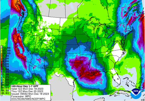
Figure 2. The Weather Prediction Center’s 7-day precipitation outlook is valid for December 18 to 25, 2023.
As of December 17, the Midwest Regional Climate Center reported the average statewide precipitation for the month so far is 1.34 inches. This total is ahead of the 30-year average amount of 1.07 inches for the entire month of December, and ties for the 25th wettest December on record, dating back to 1895 (Table 4). Kansas needs just 0.16 inches more this month to crack the top 20. A top 10 wettest December will occur if that final total reaches 2.12 inches or greater. The wettest December in Kansas was 1913 when an average of 3.15 inches fell. While that record amount appears to be out of reach, it will be interesting to see how high 2023 finishes on the list of wettest December, especially if the current precipitation forecast verifies. Stay tuned!
Table 4. The top 25 wettest Decembers on record in Kansas for the period 1895-2022, based on average statewide monthly precipitation. Source: NCEI.
|
Rank |
Year |
Precip. |
Rank |
Year |
Precip. |
Rank |
Year |
Precip. |
Rank |
Year |
Precip. |
|
1 |
1913 |
3.15 |
8 |
2018 |
2.19 |
15 |
1991 |
1.81 |
22 |
1924 |
1.46 |
|
2 |
2006 |
2.67 |
T9 |
1911 |
2.12 |
16 |
1942 |
1.77 |
23 |
1907 |
1.45 |
|
3 |
1984 |
2.63 |
T9 |
1973 |
2.12 |
17 |
1992 |
1.70 |
24 |
1980 |
1.38 |
|
4 |
1918 |
2.61 |
11 |
1997 |
2.09 |
18 |
1965 |
1.68 |
25 |
2014 |
1.34 |
|
5 |
2007 |
2.48 |
12 |
1947 |
1.98 |
19 |
1898 |
1.61 |
Normal Precipitation for December: 1.07” (based on 1991-2020) |
||
|
6 |
2015 |
2.36 |
13 |
1944 |
1.93 |
20 |
1943 |
1.50 |
|||
|
7 |
2011 |
2.26 |
14 |
1982 |
1.89 |
21 |
1895 |
1.49 |
|||
Matthew Sittel, Assistant State Climatologist
msittel@ksu.edu
Tags: weather precipitation