The current weather pattern
With the localized heavy moisture in the east, this was well forecasted with some lingering El Niño influence. An enhanced subtropical jet stream has kept enhanced upper-level winds over the region. This, combined with a favorable overall stalling of the weather pattern with low pressure over the Rockies and high pressure in the southeast (Figure 1), allows for frequent thunderstorms and heavy rain episodes. Unfortunately, it keeps them persistent over the same locations. Dry air is able to push east/northeast into the High Plains, keeping most of southwest/south central Kansas precipitation-free. This pattern of the enhanced El Niño subtropical jet stream separated from the northern jet stream (called split flow) is again similar to what we had in February and April. It results in continuous repetitive patterns with little in the way of substantial cold or warm episodes. Therefore, we don’t have a few massive storm systems that are driven by temperature contrasts. Rather, we have weak and frequent storm systems that result in modified cold air and a quick return to warmer conditions post-cold front. Until this pattern breaks, much of the Plains will see continuing severe weather with rainfall misplaced, favoring the same areas. A companion article in this eUpdate details the rainfall for March and April across Kansas and an update on drought conditions.
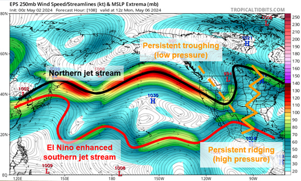
Figure 1. Upper-level winds as depicted by the EPS model of the current weather pattern across the US and Pacific next Monday morning. Source: tropicaltidbits.com, annotated by the author.
Another item of interest is the Madden-Julian Oscillation (MJO). It has remained weak, with no tropical activity around the low latitudes. These can propagate eastward around the globe, and the influx of moisture to particular areas can help break these stagnant patterns. The current weak status has aided the stagnant pattern to remain, keeping moisture favoring the same locations. We need the MJO to become more active and start moving eastward to bring more widespread moisture for those who have missed out thus far. It would also provide a brief reprieve for those who have observed way too much moisture over the last week.
Looking to the future
While it hasn’t been impactful as of late, there is some suggestion that MJO may begin to strengthen and move eastward by mid-May. This could yield a brief reprieve in the pattern with the potentially limited window for more widespread moisture. However, models aren’t overly confident at this point. Much of the wheat crop in both southwest and south-central Kansas is close, if not already, at its demise from flash drought stress. This period of moisture would be beneficial to corn and other early-planted crops.
This brief window of hope is even more concerning when we examine the continued projection for summer in Kansas. With the projection of El Niño to potentially La Niña by mid-to-late summer (Figure 2), May remains the primary transition month. Therefore, we continue to maintain increased confidence in several Kansas impacts. Severe weather is expected to continue to be above normal. These transition periods are the focus for an increase in tornado outbreaks. Over the last two weeks, we have seen that in Kansas and Central Plains. This has increased psychological stress as we are following several very quiet severe weather seasons. It will also lead to areas seeing repeated severe storms multiple times over with damage potential. However, that would continue to provide at least precipitation chances for the short term into mid-to-late May (Figure 3).
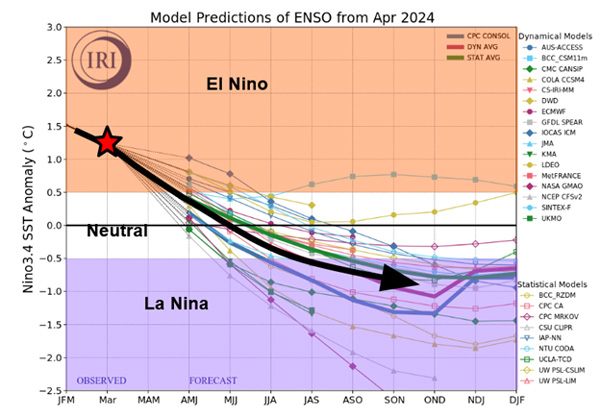
Figure 2. The current El Niño Southern Oscillation (ENSO) status is highlighted by the red star with projection into the coming months from forecast models. The overall trend is represented by the black arrow. Graphic from https://iri.columbia.edu, annotations by the author.
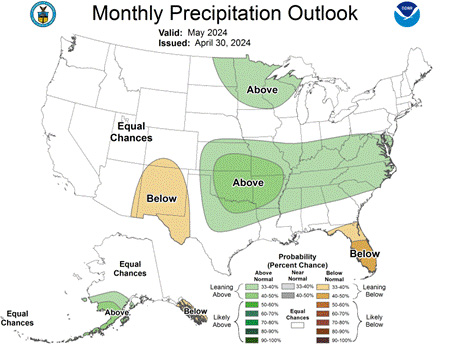
Figure 3. The May 2024 precipitation outlook for the US favors normal moisture with the highest probabilities in the southeast. Source: cpc.ncep.noaa.gov
Unfortunately, with this transition, Kansas is favored for warmer and drier-than-normal conditions this summer (Figure 4). With the current flash drought that has emerged in southwest/south-central Kansas and further south/west into Texas and New Mexico, there is potential for a negative feedback cycle. Dry conditions tend to yield drier conditions as we go into the summer. This doesn’t mean it will be completely dry, as some precipitation events will still occur. However, the overall expansion of southwest flow enhanced by La Niña (assuming it develops) will expand these dry conditions further north and east during the summer months. This will trend measured precipitation below normal, and drought will be a challenge most of the summer. While we haven’t seen it with the wheat crop, timely rains, despite dry conditions, could be a saving grace. However, summer precipitation tends to be much more isolated and spotty due to thunderstorms. Widespread precipitation is usually less common, with the haves and have-nots often being very localized.
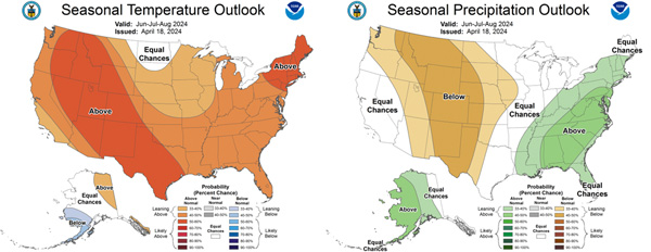
Figure 4. The June, July, and August temperature (left) and precipitation (right) outlooks from the Climate Prediction Center. Outlooks favor warmer-than-normal and drier-than-normal conditions for most of the state. Source: cpc.ncep.noaa.gov
Concluding Thoughts
A challenging spring and summer are expected. While no season/year is “normal,” the extremes are going to provide struggles for agriculture and potentially public safety. This is especially so where the drought has been expanding in the last few weeks (southwest and south-central) and where flooding has been occurring (southeast). Severe weather is going to be above normal into mid-May. This is peak severe weather season to begin with. Therefore, review your plans, have a way to receive warnings, and be prepared to shelter if necessary. With the state so split with current precipitation anomalies – make sure you utilize the current conditions. If you are seriously wet – it is a good time to make plans, train, and work on relationships. If you are seriously dry – work on digging out ponds, get field work done, and be prepared for when the rains (likely heavy) come. These challenges can be difficult both mentally and financially. Talk to your friends and family and help each other.
Chip Redmond, Kansas Mesonet Manager
christopherredmond@ksu.edu