Temperature summary
Temperatures (°F) averaged near normal during the period. Daily average temperatures across the Kansas Mesonet ranged from 58° on the 9th to 65° on the 14th. All seven daily averages during the period were within three degrees of normal. Most highs were in the 70s, with lows generally in the 40s and 50s. The coldest morning low during the period was 31° in Hamilton County on the 8th, recorded by the cooperative observer 1-mile northeast of Syracuse. This mark is likely to stand as the latest sub-freezing temperature recorded this spring in Kansas. The Stanton County Mesonet site in southwest Kansas recorded the week’s highest temperature on the 14th of 90°.
The 7-day average temperature across Kansas was 62.3° or 0.3° above normal. Seven of Kansas’ nine divisions averaged above normal for the week; only southwest and south central were below normal. Departures from normal for the period ranged from -1.0° in southwest Kansas to +2.2° in southeast Kansas. There was an average of 94 growing-degree days across the state during the period; the normal is 95. Divisional averages ranged from 79 in the northwest to 108 in the southeast. For the growing season to date, which began on April 1, there has been an average of 513 growing degree days in Kansas or 64 above the normal amount of 449. Departures from normal for the growing season range from +37 in northwest Kansas to +87 in south central Kansas.
Precipitation summary
Nearly all of the week’s precipitation fell between the 12th and the 14th. Totals over two inches were reported by CoCoRaHS observers in nine counties across multiple state divisions: Barber, Brown, Dickinson, Doniphan, Gove, Graham, Nemaha, Pottawatomie, and Riley. The three highest totals for the week were all 3” or greater and reported in Nemaha County, led by a 3.33” total in Seneca. There were a few areas where little to no rain fell. The Cheyenne County Mesonet site recorded no precipitation during the last 7 days. Totals in southwestern Kansas were mostly under one-quarter inch. Parts of east central Kansas also had low totals. Areas from Topeka to Ottawa to Garnett and Iola received mostly two-tenths of an inch or less during the week.
The statewide average precipitation for the 7-day period was 0.53”, or 52% of the weekly normal amount of 1.01”. All nine divisions in Kansas averaged below normal (Table 1). Northeast Kansas had the highest total (0.81”) while southwest Kansas was the driest division (0.26”). West central Kansas was closest to normal with 0.58”, which is 95% of normal. East central Kansas had the lowest percent of normal; the average of 0.38” was just 32% of normal. Central (38%), southeast (38%) and southwest (47%) also had less than half of normal. Since April 1, the average precipitation across Kansas is 4.26”, or 88% of the normal amount of 4.85”, down 10% since last week. The three eastern divisions all remain above normal, but north central fell to slightly below normal (99%). The remaining five divisions are all still below normal, with the lowest percent of normal 34% in southwest Kansas, where an average of just 0.92” has fallen since April 1. Central Kansas is the most below normal, with a departure for the growing season of -2.44”. Southeast Kansas continues to have the highest average precipitation and the highest percent of normal (10.15”, 142%). Since January 1, the average statewide precipitation is 7.52” or 87% of normal, or a departure of –1.08”. This total is down 5% since last week. Northwest and north central Kansas are still above normal for the year, as are the three eastern divisions. Departures for the year to date range from -3.02” in central Kansas to +2.48” in southeast Kansas. Percentages of normal range from 54% in the southwest to 119% in southeast Kansas.
Table 1. Weekly, water year, and calendar year average precipitation totals, percent of normal, and 7-day change to percent of normal for the state and each of Kansas’ nine climate divisions.
|
|
Past Week May 8 - 14 |
Growing Season Since April 1, 2024 |
Calendar Year Since January 1, 2024 |
|||||
|
Precip. |
% Normal |
Precip. |
% Normal |
% Change |
Precip. |
% Normal |
% Change |
|
|
Northwest |
0.55” |
83 |
2.88” |
88 |
-2 |
5.46” |
102 |
-4 |
|
North Central |
0.64” |
66 |
4.23” |
99 |
-10 |
7.56” |
102 |
-6 |
|
Northeast |
0.81” |
72 |
7.24” |
125 |
-12 |
10.99” |
110 |
-4 |
|
West Central |
0.58” |
95 |
1.89” |
63 |
+5 |
4.47” |
88 |
-1 |
|
Central |
0.40” |
38 |
2.12” |
46 |
-4 |
5.06” |
63 |
-4 |
|
East Central |
0.38” |
32 |
6.83” |
111 |
-20 |
12.01” |
110 |
-10 |
|
Southwest |
0.26” |
47 |
0.92” |
34 |
+4 |
2.64” |
54 |
-1 |
|
South Central |
0.73” |
71 |
3.22” |
69 |
-2 |
5.82” |
67 |
-1 |
|
Southeast |
0.56” |
38 |
10.15” |
142 |
-26 |
15.38” |
119 |
-10 |
|
STATE |
0.53” |
52 |
4.26” |
88 |
-10 |
7.52” |
87 |
-5 |
Severe weather summary
There were no reports of tornadoes during the period, but two landspouts were observed during the period. The first was in Wallace County on the 8th, and the second was in Scott County on the 12th. There were 25 reports of severe hail 1” or greater in diameter during the period. All but one of the reports came from Johnson or Wyandotte County and occurred within a 22-minute period just after sunrise on the 8th. The largest reports were 2” diameter hail in Olathe and Shawnee. There were no reports of severe wind gusts 58 mph or higher during the period.
Soil properties and other measurements
The statewide average 2” soil temperature for the period was 64.8°, up 2.0° from last week. This is 0.4° above the average value (based on Kansas Mesonet data from 2013 to 2023) of 64.4° for the 7-day period. Divisional averages ranged from 61° in northwest Kansas to 68° in south central Kansas. The average evapotranspiration for grass across the state for the week was 1.25”. This is slightly above the 10-year normal (based on Kansas Mesonet data from 2014 to 2023) of 1.21” for the 7-day period. Divisional averages ranged from 1.19” in northwest to 1.32” in south central Kansas.
Drought status
In this week’s US Drought Monitor update (Table 2; Figure 1), a new area of D3 was introduced in parts of four counties in western Kansas: Ness, Rush, Hodgeman, and Pawnee. The Wichita area was moved from D1 to D2. The D0 areas in southeast Kansas along the Oklahoma border were removed; these areas are now classified as drought-free. One-category improvements were also made in far northeastern Kansas in parts of Nemaha, Brown, and Doniphan Counties. The Drought Severity and Coverage Index (DSCI) rose 1 point this week and now stands at 159. A total of 22% of the state is now drought-free, an increase of 3% since last week. But 32% of Kansas is now in D2 or worse drought status, also up 3% from last week.
Table 2. US Drought Monitor categorical data for the state of Kansas. Numbers indicate the percent of the state in each category. D4 is the most severe category, while D0 is the least severe. None refers to drought-free conditions. DSCI is the Drought Severity Coverage Index, a composite index of overall drought conditions. Higher DSCI values indicate worse drought. The DSCI can range from a minimum of 0 (entire state drought-free) to 500 (entire state in D4).
|
Date |
None |
D0 |
D1 |
D2 |
D3 |
D4 |
DSCI |
|
5/14/2024 |
22.05 |
28.93 |
16.94 |
31.72 |
0.36 |
0.00 |
159 |
|
5/7/2024 |
19.32 |
32.13 |
19.74 |
28.81 |
0.00 |
0.00 |
158 |
|
1/1/2024 |
20.25 |
26.32 |
34.00 |
16.56 |
2.88 |
0.00 |
156 |
|
5/16/2023 |
12.80 |
6.16 |
10.24 |
11.11 |
24.20 |
35.49 |
334 |
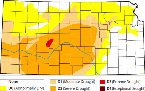
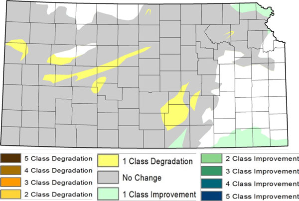
Figure 1. Current weekly drought status (top) and change in category over the past week (bottom) for Kansas. Source: US. Drought Monitor.
Weather outlooks
The Weather Prediction Center’s 7-day precipitation forecast, valid for the period May 15 through 21, calls for above-normal precipitation for the eastern half of the state, with below-normal totals favored in southwest Kansas (Figure 2). Near-normal precipitation is favored in the remainder of the state. Totals from 1.5 to 2 inches are possible in the eastern third of Kansas. Temperatures are expected to average around five degrees above normal. The average daily high and low across Kansas for this period are 77° and 53°. Average 7-day precipitation is 0.68” in western Kansas, 1.10” in central Kansas, and 1.27” in eastern Kansas. The 8 to 14-day outlook, valid for the period May 22 through 28, favors near-normal temperatures in most areas, with slightly elevated probabilities of above-normal temperatures along the Oklahoma border (Figure 3 top). Far northwestern Kansas has slightly higher chances of below-normal temperatures. Above-normal precipitation is favored statewide, with higher probabilities in the state's eastern half (Figure 3 bottom). Statewide, the probability of above-normal precipitation ranges from 37% in southwest Kansas to 45% in southeast Kansas.
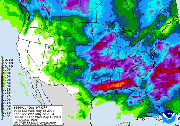
Figure 2. National Weather Service Weather Prediction Center's (NWS-WPC) 7-day precipitation forecast.
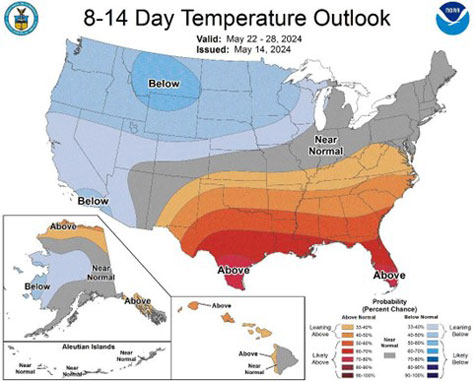
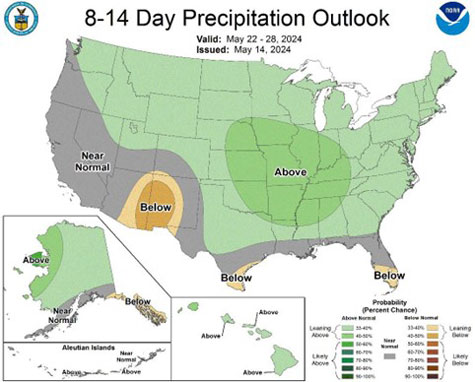
Figure 3. Climate Prediction Center's 8 to 14-day temperature (top) and precipitation (bottom) outlooks.
Matthew Sittel, Assistant State Climatologist
msittel@ksu.edu