This past week, much above-normal temperatures were again the rule across all of Kansas (Figure 1). As of February 6, the average temperature across the Kansas Mesonet has now been above normal for sixteen consecutive days. Within this stretch, the four warmest days were the first four of the reporting period when highs were mostly in the 60s, and a few locations topped out in the 70s. The highest Mesonet reading during the period was recorded at the Meade County site on February 1, when it reached 75°F (Table 1). The normal high at Meade for February 1 is 46°; 75° is the normal high for May 6. That afternoon's warmth was enough to set new record highs in southeast Kansas at El Dorado (73°) and Columbus (72°). Morning lows averaged at or above freezing for the first five days of February. The average morning low across the Kansas Mesonet on the 3rd was a mild 43°, just one degree shy of the statewide average high for the date (Table 2). Over five dozen record warmest daily minimums were set on the 4th, including at Wallace, where the low of 40° shattered the previous record of 33° set over a century ago in 1915. Goodland set new record warm minimums for the 3rd (39°) and the 4th (38°). The 7-day average temperature across Kansas was 45.5°, or 13.8° above normal. All nine divisions in the state averaged above normal; departures ranged from +11.5° in southwest Kansas to +15.7° in northeast Kansas (Figure 2).
Table 1. Temperature and precipitation extremes across Kansas during the period.
|
Extreme |
Value |
Location (Observer Category) |
County |
Date |
|
Temperature |
75° |
Lake City (Mesonet) Medicine Lodge 1E (WBAN) Wilson Lake (COOP) Coldwater (COOP) |
Barber Barber Russell Comanche |
February 1 February 1 February 2 February 2 |
|
Lowest Temperature |
19° |
Meade (Mesonet) |
Meade |
January 31 |
|
Wind Speed |
36 mph |
Konza Prairie (Mesonet) |
Riley |
February 3 |
|
Lowest Wind Chill |
20° |
Konza Prairie (Mesonet) |
Riley |
February 6 |
|
Highest 7-Day Total Precipitation |
2.58” |
Damar 1.4 NNW (CoCoRaHS) |
Rooks |
|
|
Highest 7-Day Total Snowfall |
0.0” |
--- |
--- |
Table 2. Average daily high and low temperatures (F) across the Kansas Mesonet during the 7-day report period. Maximums and minimums listed are the highest and lowest recorded in the state that day.
|
|
Wed Jan 31 |
Thu Feb 1 |
Fri Feb 2 |
Sat Feb 3 |
Sun Feb 4 |
Mon Feb 5 |
Tue Feb 6 |
||||||||
|
Avg High |
67° |
66° |
61° |
54° |
46° |
50° |
57° |
||||||||
|
Max |
Min |
73° |
61° |
75° |
51° |
74° |
43° |
60° |
48° |
49° |
42° |
57° |
38° |
66° |
51° |
|
Normals |
43° |
19° |
44° |
19° |
44° |
19° |
44° |
20° |
44° |
20° |
44° |
20° |
44° |
20° |
|
|
Avg Low |
30° |
38° |
34° |
43° |
37° |
32° |
30° |
||||||||
|
Max |
Min |
38° |
19° |
50° |
26° |
50° |
21° |
48° |
33° |
41° |
32° |
38° |
26° |
38° |
22° |
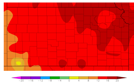
Figure 1. Departure from normal temperature (°F) for the 7-day period (Source: HPRCC).
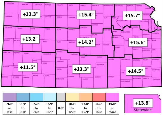
Figure 2. This week’s departures from normal temperature (°F) by climate division.
A multi-day event brought generous amounts of moisture to the state during the period, and with mild temperatures in place, precipitation was solely in the form of rain (Figure 3). The rainfall began in southwest Kansas on the afternoon of the 2nd and spread across the state on the 3rd. Eastern Kansas continued to receive light rain on the 4th, eventually ending late in the day. Storm totals were highest in northern and eastern Kansas, where many locations picked up over an inch of rainfall, with amounts over two inches measured by CoCoRaHS observers in Graham, Rooks, Trego, Ellis, and Russell Counties in northern Kansas, as well as in Butler and Cowley Counties in southeast Kansas. The highest rainfall total was 2.58” near Damar in western Rooks County. The statewide average precipitation for the 7-day period was 0.96”, or 436% of the normal amount of 0.22” (Figure 4). All divisions were much above normal; totals ranged from 0.44” in southwest to 1.45” in southeast Kansas. All divisions are running over 200% of normal for 2024, with annual departures ranging from +0.79” in the southwest to +2.36” in east central Kansas (Table 3). For the 2023-24 water year to date, which began on October 1, 2023, the statewide average precipitation is 7.42”. This amount is 123% of the normal amount of 6.05. All nine climate divisions are now above normal for the water year. Northwest Kansas jumped from 73 to 101 percent of normal over the last week, and west central went from 97 to 119 percent. Divisional totals range from 3.57” in northwest Kansas to 12.62” in east central Kansas.
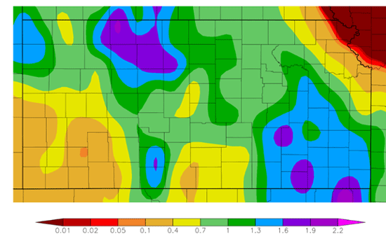
Figure 3. Total precipitation for the 7-day period (inches) (Source: HPRCC).
Table 3. Weekly, water year and calendar year average precipitation totals, percent of normal and 7-day change to percent of normal for the state and each of Kansas’ nine climate divisions.
|
|
Past Week Jan. 31 - Feb. 6 |
Calendar Year Since January 1, 2024 |
Water Year Since October 1, 2023 |
|||||
|
Precip. |
% Normal |
Precip. |
% Normal |
% Change |
Precip. |
% Normal |
% Change |
|
|
Northwest |
1.09” |
908 |
1.75” |
330 |
+169 |
3.57” |
101 |
+28 |
|
North Central |
1.18” |
562 |
2.30” |
267 |
+95 |
6.34” |
124 |
+17 |
|
Northeast |
0.73” |
292 |
2.55” |
241 |
+15 |
7.94” |
112 |
+6 |
|
West Central |
0.86” |
717 |
1.84” |
354 |
+111 |
4.02” |
119 |
+22 |
|
Central |
1.01” |
459 |
2.36” |
257 |
+64 |
7.26” |
136 |
+13 |
|
East Central |
1.13” |
404 |
3.56” |
297 |
+33 |
12.62” |
163 |
+7 |
|
Southwest |
0.44” |
400 |
1.38” |
234 |
+32 |
4.76” |
128 |
+8 |
|
South Central |
0.87” |
395 |
2.26” |
228 |
+46 |
8.72” |
145 |
+9 |
|
Southeast |
1.45” |
468 |
3.32” |
214 |
+62 |
11.23” |
120 |
+12 |
|
STATE |
0.96” |
436 |
2.34” |
241 |
+58 |
7.42” |
123 |
+12 |
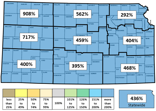
Figure 4. This week’s percentages of normal precipitation by Kansas climate division.
In this week’s US Drought Monitor update, 1-category improvements were made in parts of northwest and central Kansas (Figures 5a-b). The most extensive improvements were in north central Kansas. These changes resulted in 2% of the state being moved to drought-free status. A total of 36% of the state is now drought-free; this is the highest amount since July 2022 (Table 4). The Drought Severity and Coverage Index (DSCI) is now at 101, down 9 points from last week. Only 4% of Kansas remains in D2 or worse drought, the lowest amount since November 2021.
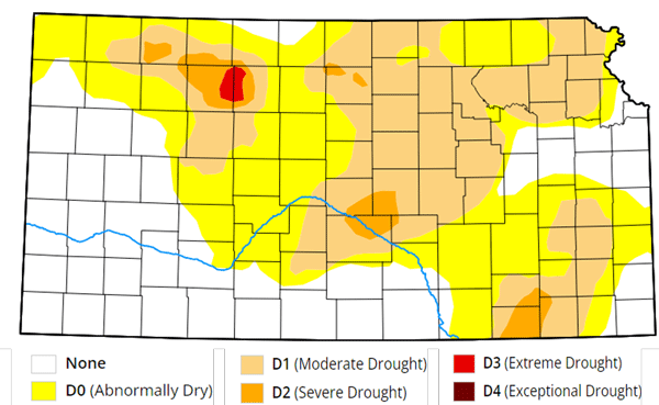
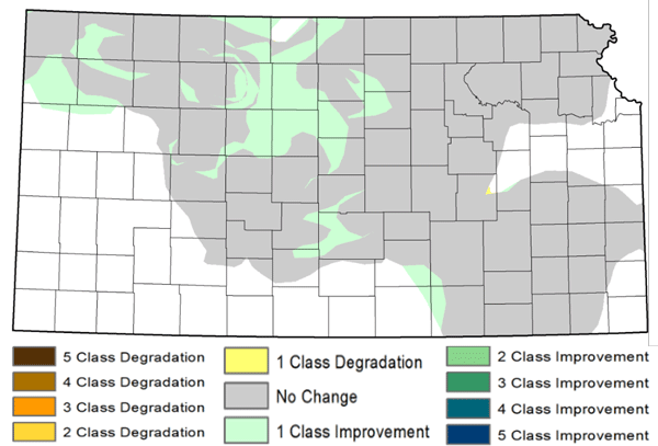
Figures 5a-b. Current weekly drought status and change in category over the past week maps for Kansas (Source: U.S. Drought Monitor, National Drought Mitigation Center).
Table 4. US Drought Monitor categorical data for the state of Kansas. Numbers indicate the percent of the state in each category. D4 is the most severe category, while D0 is the least severe. None refers to drought-free conditions. DSCI is the Drought Severity Coverage Index, a composite index of overall drought conditions. Higher DSCI values indicate worse drought. The DSCI can range from a minimum of 0 (entire state drought-free) to 500 (entire state in D4).
|
Date |
None |
D0 |
D1 |
D2 |
D3 |
D4 |
DSCI |
|
2/6/2024 |
35.80 |
31.62 |
28.79 |
3.43 |
0.35 |
0.00 |
101 |
|
1/30/2024 |
33.39 |
28.92 |
32.16 |
5.00 |
0.53 |
0.00 |
110 |
|
1/1/2024 |
20.25 |
26.32 |
34.00 |
16.56 |
2.88 |
0.00 |
156 |
|
10/1/2023 |
18.61 |
17.09 |
18.74 |
24.96 |
18.95 |
1.65 |
214 |
The average evapotranspiration (ET) for grass across the state for the week was 0.34”. This is above the 10-year normal for the 7-day period ending February 6th of 0.30”. Divisional averages ranged from 0.24” in north central Kansas to 0.40” in south central and southeast Kansas. Soil temperatures have rapidly warmed in the past week. The average 2” soil temperature across Kansas for the period was 41.6°, up 8.0° from last week. This average is 6.7° above the average value (based on Kansas Mesonet data from 2013 to 2023) of 34.9° for the 7-day period. Divisional averages ranged from 38° in northwest Kansas to 44° in south central Kansas. Soil temperatures should remain much above normal in the coming days.
The Weather Prediction Center’s 7-day total precipitation forecast, valid for the period February 7th through the 13th, calls for drier conditions than last week (Figure 6). Less than one-tenth inch of precipitation is expected across most of the state, and parts of northeast Kansas are forecast to remain dry. Temperatures are expected to average 10 to 15 degrees above normal for the period, with a cooling trend expected to begin during the weekend. The average daily high and low across Kansas for this period are 45° and 21°. Average 7-day precipitation is 0.13” in western Kansas, 0.26” in central Kansas, and 0.37” in eastern Kansas. The 8 to 14-day outlook, valid for the period February 14th through the 20th, calls for near to slightly below-normal temperatures across the state (Figure 7a). Most of eastern Kansas has equal chances of above, below, and near-normal precipitation (Figure 7b). The probability of below-normal precipitation is slightly higher in eastern Kansas, at around 35%, but this is only a couple percent above the 33% equal chances mark. Hence, a dry week is far from a certainty. Above-normal precipitation chances are favored in western Kansas, but the highest probability of this outcome is only 40% in far southwestern Kansas.
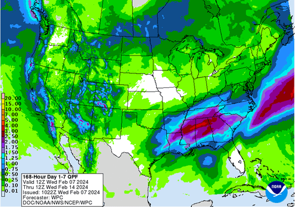
Figure 6. NOAA’s Weather Prediction Center 7-day precipitation forecast.
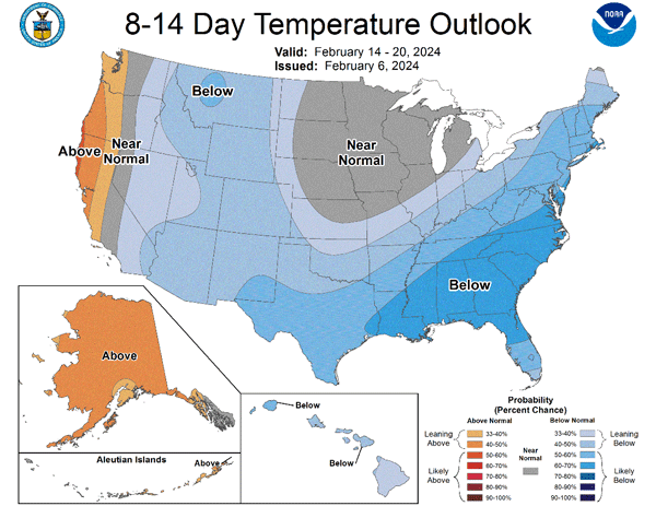
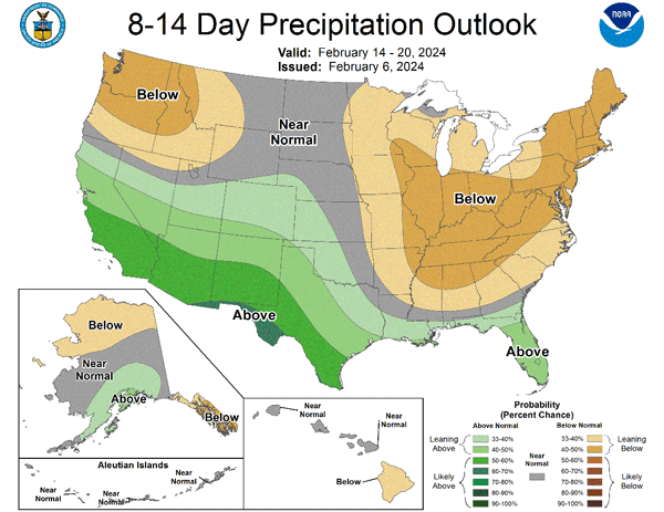
Figures 7a-b. Climate Prediction Center’s 8 to 14-day temperature and precipitation outlooks.
Matthew Sittel, Assistant State Climatologist
msittel@ksu.edu