The year 2023 ended on a quiet note (Table 1). The period began with lingering light precipitation behind the slow-moving storm system that delivered blizzard conditions to northwest Kansas the day after Christmas. While some places had measurable snow, amounts were mostly under an inch.
Temperatures moderated behind the storm system, bringing milder daytime temperatures. The 30th was the warmest day of the period, with highs mostly in the 50s across the state, with a few 60s in the southwest. The average high temperature across the Kansas Mesonet on the 30th was 54°F, or 12° above normal. Lows during the period were mostly in the 20s, with colder teens in a few areas, such as north central Kansas, where there was lingering snow cover. Colder temperatures returned as 2023 came to a close, bringing daytime highs down to near-normal values. At the beginning of 2024, midnight CST on January 1st, temperatures ranged from 15°F at the Hamilton County Mesonet site to 31°F at the Cherokee County site.
Table 1. Temperature and precipitation extremes across Kansas during the period.
|
Extreme |
Value |
Location (Observer Category) |
County |
Date |
|
Highest Temperature |
65° |
Lake City (Mesonet) Ashland (COOP) |
Barber Clark |
December 30 December 31 |
|
Lowest Temperature |
11° |
Hamilton (Mesonet) Burr Oak 4 S (COOP) Tribune 1 W (COOP) |
Hamilton Jewell Greeley |
January 1 January 1 January 2 |
|
Highest 1-Day Precipitation |
0.24” |
Soldier 7.3 S (CoCoRaHS) Prairie Village 0.8 NW (CoCoRaHS) Leavenworth 4.3 SW (CoCoRaHS) Louisburg 2.4 WNW (CoCoRaHS) |
Jackson Johnson Leavenworth Miami |
December 27 |
|
Highest 7-Day Total Precipitation |
0.32” |
Prairie Village 0.8 NW (CoCoRaHS) |
Johnson |
|
|
Highest 7-Day Total Snowfall |
3.2” |
Goff 3.9 SSW (CoCoRaHS) |
Nemaha |
The 7-day average temperature across Kansas was 33.1°F, or 2.6° above normal. All divisions averaged above normal; divisional departures ranged from +1.5° in southwest Kansas to +4.5° in northeast Kansas (Table 2; Figure 1). The statewide average precipitation for the 7-day period was 0.06 inches or 27% of the normal amount of 0.22 inches. All divisions were below normal; amounts ranged from a low of 0.01 inches in south central Kansas to a high of 0.21 inches in east central Kansas (Table 3; Figure 2). For the 2023-24 water year, which began on October 1, the statewide average precipitation is 5.22 inches, or 102% of the normal amount of 5.14 inches, a decrease of 3% over last week. Five of Kansas’ nine climate divisions are above normal for the water year. East central Kansas has the highest total (9.29 inches) as well as the highest percent of normal (141%). Northwest Kansas is the driest division (1.87 inches) and has the lowest percent of normal at 62%.
Table 2. Average daily high and low temperatures across the Kansas Mesonet during the 7-day report period. Maximums and minimums listed are the highest and lowest recorded in the state that day.
|
|
Wed Dec 27 |
Thu Dec 28 |
Fri Dec 29 |
Sat Dec 30 |
Sun Dec 31 |
Mon Jan 1 |
Tue Jan 2 |
||||||||
|
Avg High |
36° |
37° |
48° |
54° |
36° |
39° |
45° |
||||||||
|
Max |
Min |
58° |
30° |
54° |
29° |
57° |
37° |
65° |
42° |
47° |
30° |
55° |
29° |
52° |
39° |
|
Normals |
42° |
20° |
42° |
19° |
42° |
19° |
42° |
19° |
42° |
19° |
42° |
19° |
42° |
19° |
|
|
Avg Low |
27° |
24° |
25° |
25° |
23° |
20° |
21° |
||||||||
|
Max |
Min |
32° |
15° |
33° |
13° |
31° |
17° |
31° |
15° |
30° |
14° |
25° |
11° |
25° |
15° |
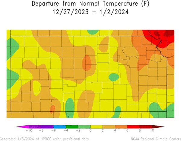
Figure 1. Departure from normal weekly mean temperatures for 12/27/2023 to 1/2/2024 (HPRCC).
Table 3. Weekly, water year, and calendar year average precipitation totals, percent of normal, and 7-day change to percent of normal for the state and each of Kansas’ nine climate divisions.
|
|
Past Week 12/27 to 1/2 |
Water Year 10/1/23 to 1/2/24 |
Past Calendar Year 1/1 to 12/31/23 |
|||
|
Precip. |
% Normal |
Precip. |
% Normal (Change) |
Precip. |
% Normal |
|
|
Northwest |
0.08” |
67 |
1.87” |
62 (-1) |
21.41” |
99 |
|
North Central |
0.03” |
17 |
4.05” |
94 (-3) |
22.55” |
79 |
|
Northeast |
0.14” |
61 |
5.52” |
91 (-1) |
28.32” |
78 |
|
West Central |
0.06” |
43 |
2.35” |
81 (-3) |
20.72” |
101 |
|
Central |
0.02” |
11 |
5.03” |
112 (-5) |
24.08” |
81 |
|
East Central |
0.21” |
81 |
9.29” |
141 (-3) |
30.96” |
82 |
|
Southwest |
0.03” |
18 |
3.57” |
113 (-6) |
25.19” |
126 |
|
South Central |
0.01” |
5 |
6.62” |
130 (-7) |
29.92” |
98 |
|
Southeast |
0.02” |
6 |
8.06” |
102 (-3) |
29.26” |
70 |
|
STATE |
0.06” |
27 |
5.22” |
102 (-3) |
25.89” |
84 |
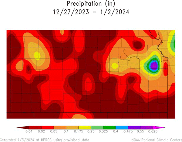
Figure 2. Total precipitation for the week (HPRCC).
The average evapotranspiration (ET) for grass across the state for the week was 0.21 inches. This is below the 10-year normal for the 7 days ending January 2 of 0.24 inches. Divisional averages ranged from 0.16 inches in north central to 0.27 inches in southwest Kansas. Cooler temperatures this past week resulted in a drop in soil temperatures. The week’s average 2-inch soil temperature across Kansas was 36.8°F, down 5.8° from last week. This average is 2.4° above the 10-year normal of 34.4°F. Divisional averages ranged from 34°F in northwest Kansas to 41°F in southeast Kansas. Three Mesonet sites recorded a 2-inch soil temperature at or below freezing at least once during the period. The most time during the period that 2-inch soil temperatures were at or below freezing at a Mesonet site was 5.9 hours at Oberlin 7NE in Decatur County.
The only change in this week’s US Drought Monitor was the removal of D0 in southern Morton and Stevens Counties, returning these areas to drought-free status. The rest of the state had no change in drought conditions. The D0 removal in southwest Kansas brought the percentage of drought-free areas in the state up to 21%, an increase of 1% over last week. The Drought Severity and Coverage Index (DSCI) fell 1 point to 155, the lowest DSCI since July 5, 2022. A total of 19% of Kansas is in D2 or worse drought (Figure 3). This is the lowest percentage since February 2022.
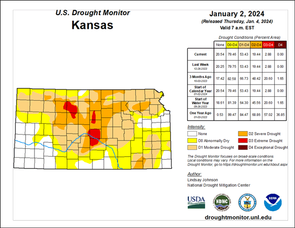
Figure 3. Current weekly drought status (U.S. Drought Monitor).
Looking ahead
The Weather Prediction Center’s 7-day total precipitation forecast, valid for January 3-9, calls for above-normal precipitation statewide. Totals over half an inch are expected across the southern third of the state, with totals as high as 1.5” possible in southeastern Kansas (Figure 4).
Temperatures are expected to average a few degrees above normal. The average daily high and low across Kansas for this period are 42°F and 19°F. Average 7-day precipitation is 0.11 inches in western Kansas, 0.16 inches in central Kansas, and 0.25 inches in eastern Kansas.
The 8 to 14-day outlook, valid for January 10-16, says below-normal temperatures are likely for most of the state, particularly in western Kansas, where the probabilities of below-normal temperatures exceed 60% (Figure 5). Neither above nor below precipitation is favored in the outlook; the probabilities of above, below, and near normal precipitation all range from 30 to 40% statewide.
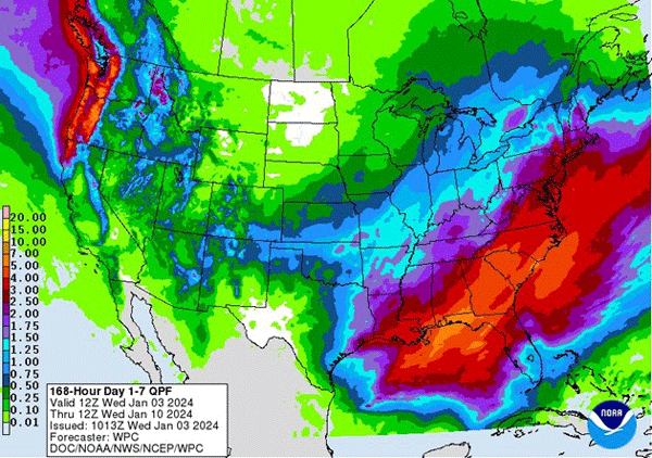
Figure 4. NOAA’s Weather Prediction Center 7-day precipitation forecast.
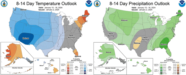
Figure 5. Climate Prediction Center’s 8 to 14-day temperature and precipitation outlooks.
Matthew Sittel, Assistant State Climatologist
msittel@ksu.edu