After a very warm finish to November the heat continued into early December. While this paled in comparison to summer heat, it still had big impacts. The most substantial impacts have been warm soil temperatures, increased evaporation, drought expansion/intensification, and a slowly growing fire season concern.
Since Thanksgiving, 111 maximum temperature records have been broken in Kansas as of December 4 (Figure 1). In addition, another 19 records were tied. Of these records, nine different locations broke their record by nine or more degrees. Seventeen monthly records were broken during the period (with another seven tied). Lastly, seven record high low temperatures (warm overnights) were set.
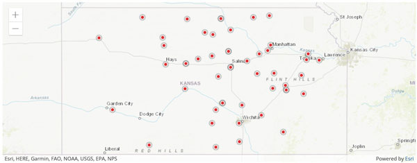
Figure 1. Locations of PROVISIONAL maximum records set from November 25 to December 4, 2021 in Kansas from National Centers for Environmental Information (NCEI). Source: https://www.ncdc.noaa.gov/cdo-web/datatools/records
On the cold side, no record low temperatures were set during this period, nor the lowest maximum (cold daytime high temperatures). The start of December is the beginning of meteorological winter (December through February), a period we would expect to be the coolest season in Kansas. The normal statewide average temperature from Thanksgiving to December 8 is 37°F. This year however, the statewide average temperature was 45°, 8 degrees above normal.
This recent warmth follows a trend that has been associated with both recent Novembers and winters. According to the National Centers for Environmental Information (NCEI), Kansas has observed as much as 0.2-0.3°/decade warmth in November and up to 0.4°/decade for all of winter (Figure 2). While these may seem like small impacts, they can have lasting results on agriculture, pests, and precipitation demand trends. This doesn’t mean that there aren’t outliers with cold months and seasons, just that long-term averages are indicative of slow trends over time.
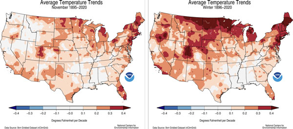
Figure 2. Average temperature change per decade for November (left) and winter (December through February). Maps from NCEI - https://www.ncdc.noaa.gov/temp-and-precip/us-trends/tavg/win.
Warm temperatures likely to continue
Looking forward to the future, the warmth isn’t forecasted to end any time soon. While a few cooler days are expected, the forecast into the end of the month calls for above-average temperatures. The next 6-10 days have an unprecedented 80-90% confidence of above-normal temperatures (Figure 3). Some forecast models suggest temperatures as warm as 15-20° above normal for the upcoming week. Even beyond that period, above-normal temperatures are favored through the remainder of December.
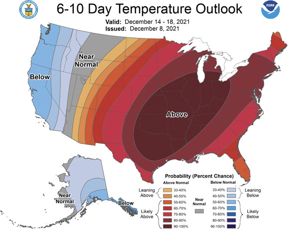
Figure 3. Climate Prediction Center outlook for December 14-18, 2021. The outlook favors above-normal temperatures for much of the continental US (cpc.ncep.noaa.gov).
Usually where there is one extreme, another exists to counter it. From Figure 3, the cooler air and below-normal temperatures are favored for the West Coast. Looking further northwest (Figure 4), very cold temperatures, as much as 12-18° below normal, persist for western Canada and Alaska. This will be an area to watch in the coming months. While current forecast models have much of this cooler air remaining over those regions, it is entirely possible that a pattern shift could usher some of that air southeastward. La Nina, combined with several other oscillations, are driving the current pattern. However, as we continue into the winter, La Nina results usually diminish. Other patterns, such as the Arctic Oscillation which drives Polar Vortex intrusions like those observed in February, can often become more dominant. With arctic air in place downstream, it’ll be something that needs to be monitored closely for the coming months. However, current outlooks (Figure 5, left) and the latest model guidance (Figure 5, right) aren’t optimistic on this cold air intruding the Central Plains at this time. Snow and cold lovers may hope that this outlook will change!
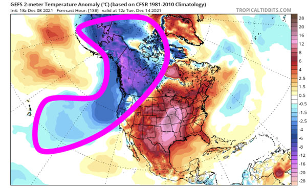
Figure 4. Forecasted surface temperature anomalies for December 14, 2021 compared to normal across North America from the GEFS model (tropicaltidbits.com).
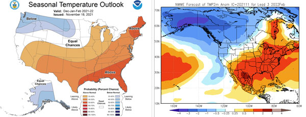
Figure 5. Winter (December through February) CPC forecast (left) and the North American Multi-Model Ensemble (NMME) temperature anomaly forecasted for February (right). Source: cpc.ncep.noaa.gov and https://www.cpc.ncep.noaa.gov/products/NMME/
Christopher “Chip” Redmond, Kansas Mesonet/Weather Data Library
christopherredmond@ksu.edu
Tags: weather Climate warm temperatures