Temperature summary
Meteorological fall ended on November 30, and the season closed on a chilly note thanks to an extended period of below-normal temperatures that arrived Thanksgiving week and lingered through the start of meteorological winter. Daily average temperatures across the Kansas Mesonet were below normal on all 7 days of the period. This puts the number of consecutive days below normal at 9 (as of December 3), which is the longest run since a 9-day stretch back in early July. For comparative purposes, this year's longest run of below-normal days is 13 during the bitterly cold spell in mid-January. One day during the period with an above-normal average high was December 3rd when a prevailing south wind boosted readings in western Kansas to well above seasonal normals. After a cold morning low of 25°, Goodland’s high of 70° on the 3rd was 24 degrees above the normal high for the date of 46°. One county south, the cooperative observer at Wallace bested Goodland by a degree, topping out at 71°, the week’s warmest reading. Morning lows averaged below freezing on all 7 days and averaged in the teens on four mornings. The Silver Lake Mesonet site in Shawnee County recorded the coldest temperature of the week on the 1st at 9°. The nearby Rossville tower recorded a low of 10°. Both lows resulted from fresh snow cover that blanketed northeast Kansas the preceding day. The 7-day average temperature was 32.4°, or 4.9° below normal (Figure 1). All nine divisions were above normal for the week; departures ranged from -9.0° in northeast to -1.0° in northwest and west central Kansas.
Precipitation summary
There were two precipitation events of note during the period. The first event began late on the 26th in northwest Kansas and spread across much of the state on the 27th. Temperatures were warm enough for a cold rain in most areas, but there were reports of freezing rain in far northern Kansas and snow in parts of the northwest. Hoxie in Sheridan County picked up half an inch of snow from the event. Liquid precipitation amounts around the state were generally under two-tenths of an inch, with isolated higher totals. The CoCoRaHS observer west of Oberlin in Decatur County measured 0.44” for the event. The second event was on the 30th, and with colder air in place, the precipitation fell as snow, mainly impacting northeast and east central Kansas. A narrow but intense band of snow brought accumulating snowfall to these areas, with rates over 1 inch per hour observed in many locations. Totals exceeded forecasted amounts, and a Winter Weather Advisory was issued for the morning hours as roads became snow-covered, leading to hazardous driving conditions. Hoyt in Jackson County had the highest snow total of 5.5”. Leavenworth received 4.5” of snow, and the official total for Topeka was 3.3”. Amounts from 1 to 4 inches were observed in the western Kansas City suburbs and the Lawrence area, while totals in Manhattan were around one inch.
The statewide average precipitation for the 7-day period was 0.09”, or 31% of the normal amount of 0.29” (Figure 1). Only two divisions were above normal: west central (140%) and northwest (117%) Kansas. The highest total was east central Kansas with 0.19”. South central had the lowest total with just 0.02”. Precipitation remains above normal for the water year, which began on October 1. The average statewide total for the water year is 6.05”, or 2.03” above the normal amount of 4.02”. All nine divisions are above normal, with percents of normal ranging from 126% in the northeast to 211% in southwest Kansas. Departures from normal range from +1.17” in north central to +3.59” in southeast Kansas. For the year, the statewide average precipitation is 27.72”, or 2.13” below normal. Three divisions are above normal for the year: southwest (113%), west central (106%), and east central (100%). North central has the lowest percent of normal (87%) as well as the largest departure from normal (-3.70”).
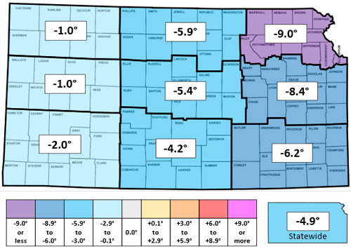
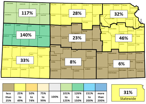
Figure 1. This week’s departure from normal temperature (°F, top) and percent of normal precipitation (bottom) by Kansas climate division. Source: MRCC.
Evapotranspiration and soil temperatures
The average evapotranspiration for grass across the state for the week was 0.23”. This is well below the normal amount of 0.36” for the 7-day period. Divisional averages ranged from 0.18” in east central to 0.27” in west central Kansas. The statewide average 2” soil temperature across the Kansas Mesonet fell another 5.2° this week to 39.5°. This average is 1.5° below the normal of 41.0° for the 7-day period. Divisional averages ranged from 36° in northwest to 44° in southeast Kansas.
Drought update
In this week’s US Drought Monitor map, there were a few changes, all for the better (Figure 2). Parts of 14 counties were improved by one category. These changes include new drought-free areas in parts of four counties along the Colorado border: Sherman, Wallace, Greeley, and Hamilton. The percentage of drought-free areas in the state increased to 31.3%, up 0.9% from last week. The remaining changes in this week’s map were improvements from D1 to D0 in west central and east central Kansas. The statewide Drought Severity and Coverage Index (DSCI) fell 3 points and now stands at 98. The DSCI is under 100 for the first time since July 23.
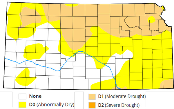
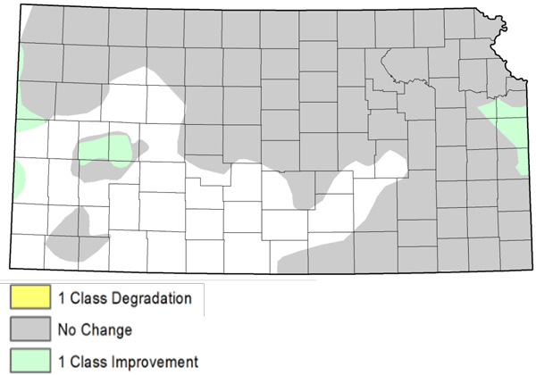
Figure 2. Current weekly drought status (top) and change in drought category over the past week (bottom). Source: UNL Drought Monitor.
Weather outlooks
The Weather Prediction Center’s 7-day precipitation forecast, valid for December 4-10, calls for a dry week, with no precipitation expected anywhere in the state (Figure 3). A return to milder conditions is expected, and temperatures should average from 3 to 9 degrees above normal. The warmest day is likely to be Sunday, when highs may reach into the 60s, especially in western Kansas. The average daily high and low across Kansas for this period are 46° and 23°. Average 7-day precipitation is 0.14” in western, 0.26” in central, and 0.40” in eastern Kansas.
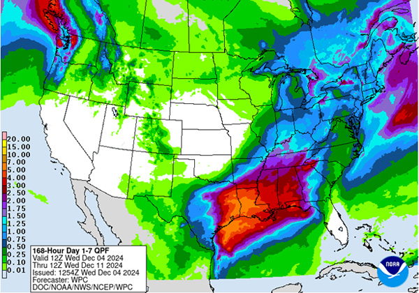
Figure 3. The National Weather Service Weather Prediction Center’s (NWS-WPC) 7-day precipitation forecast (Dec. 4 to Dec. 10, 2024).
In the longer term, the 8 to 14-day outlook, valid for December 11-17, slightly favors above-normal temperatures for all but far southern Kansas (Figure 4). The probability of above-normal temperatures ranges from 32% in the far south to 38% in the northwest. Above-normal precipitation is very slightly favored in the southwest, with a maximum probability of just 34%. Near-normal precipitation is favored elsewhere, with a maximum probability of 36%. Given that the maximum probabilities are close to the 33% equal chances threshold, this forecast should be considered a low-confidence forecast.
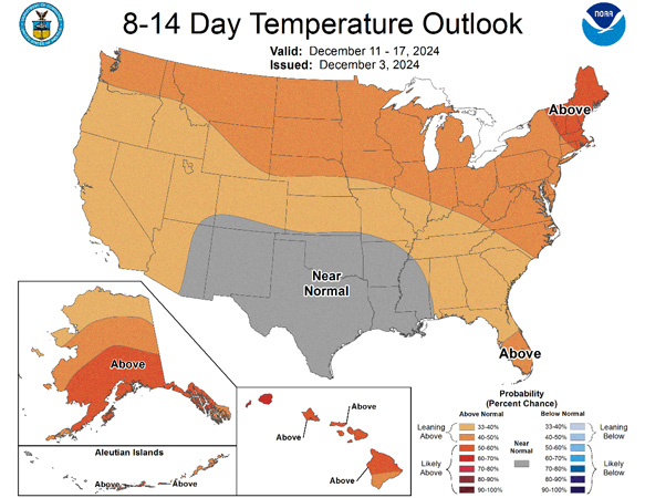
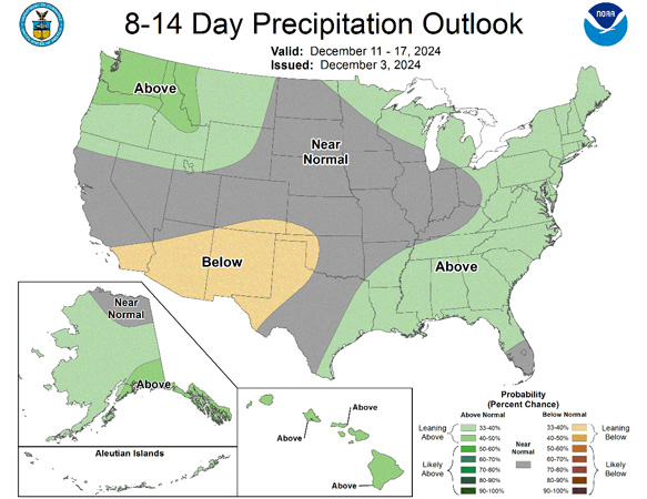
Figure 4.The National Weather Service Climate Prediction Center’s (NWS-CPC) 8 to 14-day temperature (top) and precipitation (bottom) outlooks.
Looking even further ahead, the Climate Prediction Center’s weeks 3 and 4 outlook, valid for the 14-day period from December 14-27, calls for equal chances of above and below temperatures statewide (Figure 5). The entire state also has equal chances of above and below precipitation.
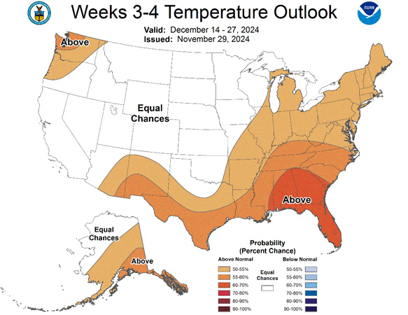
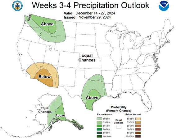
Figure 5.The Climate Prediction Center’s weeks 3 and 4 outlooks for temperature (left) and precipitation (right).
This article is a shortened version of the weekly Kansas Drought Update and Climate Report. If you would like to receive the full report delivered to your email each week, please send a request to Matt at msittel@ksu.edu. He will add you to his distribution list.
Matthew Sittel, Assistant State Climatologist
msittel@ksu.edu