Temperature summary
Temperatures began the period above normal, continuing a stretch of warmth that began on the 17th. Highs on the 24th across the Kansas Mesonet averaged 86°, the first of three days during the period in which statewide average highs were at least 20 degrees above normal. There was a brief cooldown with near-normal temperatures on the 25th and 26th. About half of the Mesonet sites recorded a freeze on the morning of the 26th, with the Osborne County site the coldest at 26°. The 26th was the first below-normal day in 10 days, but the cooler conditions were short-lived, as warmer temperatures returned on the 27th and lasted through the end of the period. Highs on the 28th and 29th averaged in the mid-80s. Over 75 new daily record highs were set during the week, including at Liberal (93°), El Dorado (92°), and Coldwater (91°) on the 24th. Ashland (94°, 97°) and Topeka (92°, 86°) both set daily records on the 24th and 28th, as did Wichita (93°, 90°), where the latter now stands as the latest 90-degree reading in the fall, besting the previous latest of October 26th, 2014. In addition, over 50 record-high minimum temperatures were set on the 29th or 30th as strong southerly winds kept overnight lows at unseasonably warm levels.
The statewide average low on the 29th was 62°, and a few locations failed to fall below 70°, resulting in new records for the latest fall 70-degree low temperature at Topeka (72°, the old record for the latest was Oct. 24), Chanute (71°, Oct. 26) and Emporia (71°, Oct. 17). The 69° lows at Concordia, Salina, and Wichita were also new marks for warmest so late into the fall season. Normal lows at these three locations are 38°, 39°, and 42°, respectively. The statewide 7-day average temperature was 60.3° or 8.5° above normal (Figure 1). All nine divisions were well above normal; divisional departures ranged from +7.4° in northwest to +10.7° in southeast Kansas. The average temperature this month through the 29th is 62.5°, or 6.1° above normal. If the average remains at this value at month’s end, it will be the 4th warmest October on record and the warmest October in Kansas since 1963.
Precipitation summary
The main precipitation event during the period impacted eastern and south central Kansas on the evening of the 24th. A line of storms rapidly formed before sunset and tracked east across these areas, exiting the state shortly after midnight. Some of the storms were severe; there were twelve reports of severe wind gusts of 58 mph or greater, the highest of which was 71 mph in Atchison County south of Lancaster. Four reports of 1” diameter hail were also received from Atchison, Jefferson, and Pottawatomie Counties. CoCoRaHS observers measured rainfall totals of over one inch in four counties: Shawnee, Jefferson, Leavenworth, and Atchison. The highest total was 1.60” south-southwest of Leavenworth. Topeka’s official total was 1.39”, their highest 1-day amount since July 4th. Parts of Harvey and Cowley Counties picked up between one-half and three-quarters of an inch of rainfall. In between the two, Wichita-Eisenhower only managed 0.10” from the storms, an example of the variation in intensity of the storms within the line. In western Kansas, it was another dry week for most areas, with no precipitation noted in Dodge City, Garden City, and Colby.
The statewide average precipitation for the 7-day period was just 0.08”, or 17% of the normal weekly amount of 0.48” (Figure 1). All divisions were below normal, with four divisions averaging zero: northwest, north central, west central, and southwest, with just 0.01” in central Kansas. Northeast (0.27”) and east central (0.25”) were the two wettest divisions. The average precipitation for October is 0.35”, which would be the 4th driest October on record and the driest since 1995 should this amount end up as the monthly statewide average. The forecast suggests this is very unlikely, with precipitation expected before the end of the month.
Since April 1, the average precipitation across Kansas is 18.76”, or 77% of the normal amount of 23.95”, a departure of -5.66”. Southeast Kansas is the division with the largest departure from normal (-7.33”), followed by central (-6.93”) and north central (-6.65”) Kansas. Divisional percents of normal range from 71% in central and north central Kansas to 93% in southwest Kansas. A total of 87% of the state is running below normal for the growing season. Since January 1st, the average statewide precipitation is 22.03”. This amount is 78% of normal or a departure of -6.14”. All divisions remain below normal for the year; departures from normal range from -7.86” in southeast to -1.61” in southwest Kansas. A total of 87% of the state is below normal for the year.
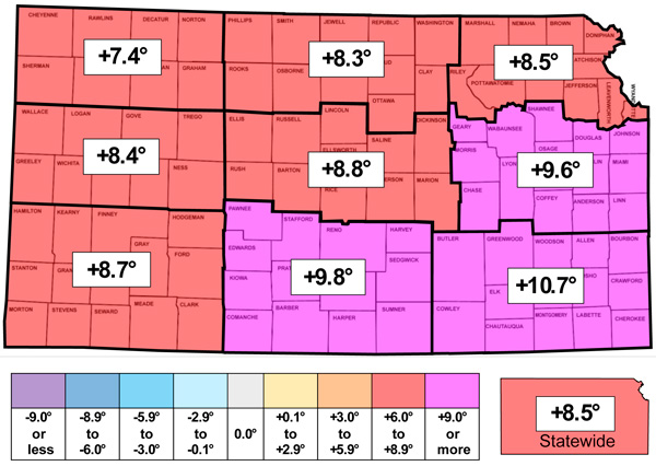
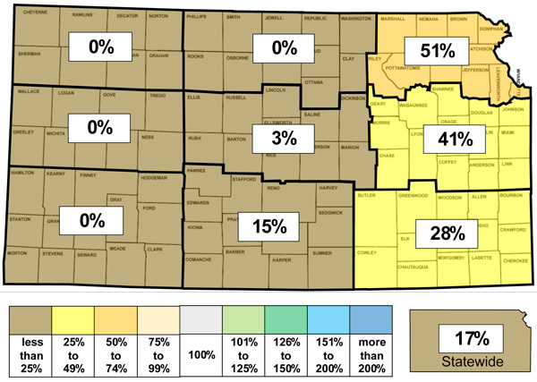
Figure 1. This week’s departure from normal temperature (°F, top) and percent of normal precipitation (bottom) by Kansas climate division. Source: MRCC.
Growing degree days, evapotranspiration, and soil temperatures
There was an average of 101 growing degree days across the state this past week, or 43 above the normal amount of 58. Divisional totals ranged from 84 in northwest to 114 in southeast Kansas. Departures ranged from +32 in northwest to +51 in northeast and southeast Kansas. Since April 1st, there has been an average of 4,091 growing degree days in Kansas or 244 above normal. There was an average of 4 corn stress degree days across the state this past week; normal is zero, as temperatures above 86° are uncommon this late in the fall. The average evapotranspiration for grass across the state for the week was 1.04”. This is much above the normal of 0.61” for the 7-day period. Divisional averages ranged from 0.85” in northwest to 1.22” in south central Kansas. The statewide average 2” soil temperature across the Kansas Mesonet fell 0.7° this week to 60.4°. This average is 4.9° above the normal of 55.5° for the 7-day period.
Drought update
In this week’s US Drought Monitor update, there were once again no areas of improvement made anywhere in the state (Figure 2). The predominantly dry week across the state was reflected in numerous but small areas of one-category degradations added around the state. Communities within the areas of degradation include Fort Scott, Wellington, Marysville, Scott City, and Elkhart. The area of D3 along the Oklahoma and Missouri borders was expanded further north and west and has nearly doubled in size since last week, now encompassing 3.9% of the state. Just 1.6% of the state remains free of any drought status. 32% of the state is in D2 or worse status, up 6% since last week. The statewide Drought Severity and Coverage Index (DSCI) rose for the fifth consecutive week. The DSCI increased by 9 points and now stands at 211, the highest DSCI since late October of 2023.
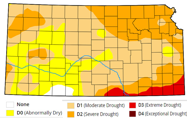
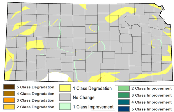
Figure 2. Current weekly drought status (top) and change in drought category over the past week (bottom). Source: UNL Drought Monitor.
Weather outlooks
The Weather Prediction Center’s 7-day precipitation forecast, valid for October 30 through November 5, forecasts precipitation for all of Kansas, with above-normal precipitation expected in all but western Kansas (Figure 3). In the state's eastern half, heavy rain of 2 inches or more is forecast. More than 5 inches of rain is possible south and east of a line from Atchison to Topeka to Wichita. An event of this magnitude is rare, particularly this time of year. It has been 26 years in Wichita since a 7-day event exceeding 5 inches occurred entirely or partly within November. It last happened in 1998 when 8.74” of precipitation fell between October 28th and November 3rd. The same event brought 5.71” of rain to Topeka, and an average of 4.13” fell across Kansas. This led to November 1998 ending up as the 2nd wettest November in Kansas, behind only 1909. By comparison, the average precipitation across Kansas for November averages just 1.30”, with southeast Kansas the wettest division on average at 2.33”. Thus, the forecast weekly amounts could be two to three times the monthly average. Temperatures during the forecast period are expected to remain very mild, averaging from 5 to 10 degrees above normal. The average daily high and low across Kansas for this period are 62° and 36°. Average 7-day precipitation is 0.24” in western Kansas, 0.36” in central Kansas, and 0.57” in eastern Kansas.
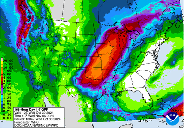
Figure 3. The National Weather Service Weather Prediction Center’s (NWS-WPC) 7-day precipitation forecast (Oct. 30 – Nov. 6, 2024).
The 8 to 14-day outlook, valid for the period November 6th through the 12th, slightly favors above-normal temperatures in the east and central areas, with near-normal temperatures favored in the southwest (Figure 4). The maximum probability for above-normal temperatures is 40% in far northeastern Kansas. Above normal precipitation is favored in all areas, with probabilities ranging from 38% in the northwest to 45% in the southeast.
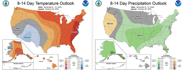
Figure 4.The National Weather Service Climate Prediction Center’s (NWS-CPC) 8 to 14-day temperature (left) and precipitation (right) outlooks.
Looking even further ahead, the Climate Prediction Center’s weeks 3 and 4 outlook (Figure 5), valid for the 14-day period from November 9th through the 22nd, slightly favors above-normal temperatures (50-55% probability) in the far southwest, with equal chances of above-normal and below-normal temperatures elsewhere. There are also equal chances of above-normal and below-normal precipitation forecast for the entire state.
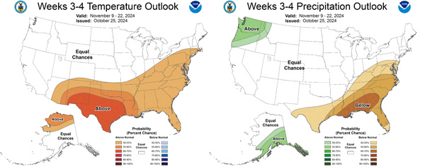
Figure 5.The Climate Prediction Center’s weeks 3 and 4 outlooks for temperature (left) and precipitation (right).
This article is a shortened version of the weekly Kansas Drought Update and Climate Report. If you would like to receive the full report delivered to your email each week, please send a request to Matt at msittel@ksu.edu. He will add you to his distribution list.
Matthew Sittel, Assistant State Climatologist
msittel@ksu.edu