Temperature summary
The period began on a chilly note, with the first widespread freeze of the fall season on the morning of the 16th for most of the state. Only a dozen Mesonet sites failed to reach 32°F. Five sites registered very cold lows in the teens, led by Phillipsburg, where the low was 18°, the week’s coldest reading and also the coldest temperature in the state so far this fall. Over a dozen record lows were set or tied that morning, including at Hutchinson (23°), Salina (24°), Hill City (24°), Russell (25°), and Chanute (27°). The 16th was the only day below normal for the period, and a rapid warmup ensued the following day. Morning lows after the 16th averaged above normal for the remainder of the period. Lows from the 18th through the 22nd averaged from 49° to 52° or 8 to 10 degrees above normal.
Daytime highs averaged in the mid to upper 70s from the 17th through the 21st. The 22nd was the warmest day, with a statewide average high of 85°. A few 90s were recorded in southern Kansas. Four locations shared honors for the week’s warmest temperature of 93° that afternoon: Chanute, Winfield, Parsons, and Sedan. This was warm enough to tie or set new record highs for the date at all four locations. Additional record highs for the 22nd were set at Wichita (88°), Emporia (88°), and Olathe-Industrial Airport (86°). The statewide 7-day average temperature was 59.5°, or 4.7° above normal (Figure 1). All nine divisions were above normal; divisional departures ranged from +1.0° in southeast to +8.4° in northwest Kansas. The average temperature this month through the 22nd stands at 62.5°, or 4.4° above normal. If the average remains at this value at the end of the month, it will be the 4th warmest October on record and the warmest October in Kansas since 1963.
Precipitation summary
A storm system that was forecast last week to deliver significant precipitation to the western half of the state delivered some rainfall, but not as much as was anticipated. Totals in southwest Kansas, the area expected to receive up to 2 inches of rain, were much lower, as locations further north ended up getting more rain. Counties along the Colorado border in west central and northwest Kansas generally picked up from one-half to one inch of rain. Further east, there were isolated pockets of higher totals. CoCoRaHS observers in Ness, Trego, and Graham Counties reported between 1 and 1.25” precipitation. One county had even more rainfall. A severe thunderstorm impacted parts of Phillips County on the afternoon of the 21st. The Kansas Mesonet site 1-mile southwest of Phillipsburg received 2.60” of rain in just 80 minutes. Large hail accompanied this storm, as the town of Glade was pelted with golf-ball size hail, and there were multiple reports in Phillipsburg of hail from 1 to 1.5” in diameter. Further to the east, lighter amounts were reported, and areas east of a line from Wichita to Manhattan to Hiawatha picked up a quarter inch of rain or less. Most of southeastern Kansas missed out entirely, and many locations are still precipitation-free for the month, including El Dorado, Independence, Iola, Parsons, and Pittsburg.
The statewide average precipitation for the 7-day period was 0.27”, or 46% of the normal weekly amount of 0.58” (Figure 1). Two divisions had above-normal precipitation and were also the two wettest divisions this past week: west central (0.49”; 127%) and northwest (0.46”; 112%). Southeast Kansas was the driest division (0.02”). The average precipitation for October is also 0.27”, which would be the 2nd driest October on record and the driest since 1952 should this amount end up as the monthly statewide average. Since April 1st, the average precipitation across Kansas is 18.69”, which is 78% of the normal amount of 23.95”, a departure of -5.26”. Southeast Kansas is now the division with the largest departure from normal (-6.83”), followed by central (-6.51”) and north central (-6.10”) Kansas. Divisional percentages of normal range from 72% in central Kansas to 95% in southwest Kansas. A total of 84% of the state is running below normal for the growing season. Since January 1st, the average statewide precipitation is 21.96”. This amount is 79% of normal or a departure of -5.74”. All divisions remain below normal for the year; departures from normal range from -7.36” in southwest to -1.24” in southwest Kansas. A total of 85% of the state is below normal for the year.
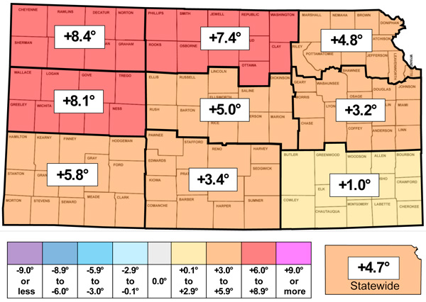
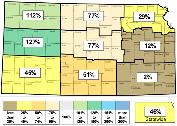
Figure 1. This week’s departure from normal temperature (°F, top) and percent of normal precipitation (bottom) by Kansas climate division. Source: MRCC.
Growing degree days, evapotranspiration, and soil temperatures
There was an average of 95 growing degree days across the state this past week, or 27 above the normal amount of 68. Divisional totals ranged from 88 in northwest to 98 in north central Kansas. Departures ranged from +20 in southeast to +35 in north central Kansas. Since April 1st, there has been an average of 3,991 growing degree days in Kansas, or 201 above normal. There was an average of 1 corn stress degree day across the state this past week which is normal. The average evapotranspiration for grass across the state for the week was 1.07”. This is well above the normal of 0.82” for the 7-day period. Divisional averages ranged from 0.96” in east central to 1.19” in central Kansas. The statewide average 2” soil temperature across the Kansas Mesonet fell 4.1° this week to 61.1°. This average is 2.7° above normal.
Drought update
In this week’s US Drought Monitor update (Figure 2), one-category degradations were made to much of the eastern half of Kansas, with two small areas of degradation in southwest Kansas. Wichita is now in D1, and Topeka is now in D2. A total of seven counties are partially in D3, all along the Oklahoma and/or Missouri borders. The D3 area includes the towns of Coffeyville, Oswego and Baxter Springs. Collectively, D3 covers 2.1% of Kansas, the highest amount since the first week in January. Only 1.7% of the state remains free of any drought status, down from 3.3% last week. Parts of three counties comprise this area: Meade, Clark and Comanche. A total of 25.9% of the state is in D2 or worse status, up nearly 10 percent since last week. The statewide Drought Severity and Coverage Index (DSCI) rose 23 points and now stands at 202, the highest DSCI since last November.
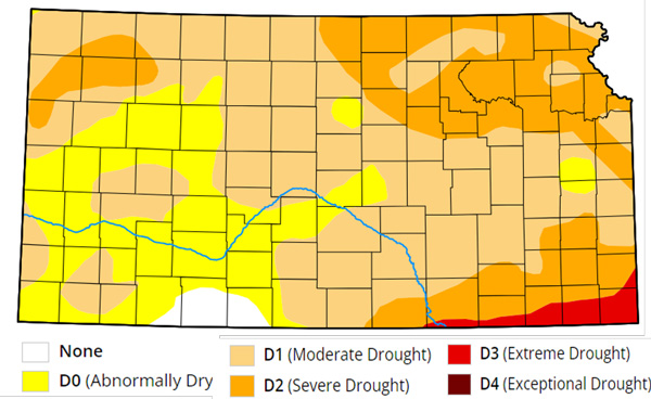
Figure 2. Drought status for the week ending on October 22, 2024. Source: UNL Drought Monitor.
Weather outlooks
The Weather Prediction Center’s 7-day precipitation forecast, valid for October 23 through the 29th, forecasts no precipitation in the western third of Kansas (Figure 3). In the eastern two-thirds of the state, below-normal precipitation is expected in most areas, but parts of east central Kansas could receive as much as one inch of rain. Another very mild week is expected, with temperatures expected to average from 9 to 14 degrees above normal. Record highs may be set on the 24th, with highs in the 80s to low 90s expected. The average daily high and low across Kansas for this period are 65° and 39°. Average 7-day precipitation is 0.32” in western Kansas, 0.42” in central Kansas, and 0.63” in eastern Kansas.
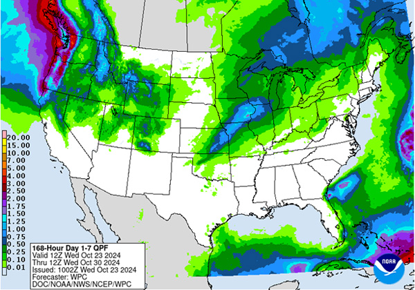
Figure 3. The National Weather Service Weather Prediction Center’s (NWS-WPC) 7-day precipitation forecast.
The 8 to 14-day outlook, valid for October 30th through November 5th, favors above-normal temperatures in all areas, with increasing probabilities from northwest to southeast (Figure 4). The probabilities of above-normal temperatures range from 39% in the far northwest to 60% in the southeast corner of Kansas. Precipitation probabilities favor above-normal amounts, with increasing probabilities from west to east. Probabilities range from 36% in western to 46% in eastern Kansas.
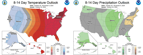
Figure 4.The National Weather Service Climate Prediction Center’s (NWS-CPC) 8 to 14-day temperature (left) and precipitation (right) outlooks.
Looking even further ahead, the Climate Prediction Center’s weeks 3 and 4 outlooks, valid for the 14-day period from November 2 through the 15th, slightly favors above-normal temperatures (50-55%) across far southern and east central Kansas, with equal chances of above and below normal temperatures in the remainder of the state (Figure 5). Below-normal precipitation is favored in the western half of the state, with the highest probabilities in far western Kansas (55-60%). Equal chances of above and below-normal precipitation are forecast for the eastern half of Kansas.
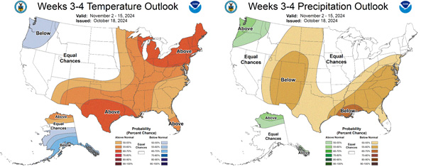
Figure 5.The Climate Prediction Center’s weeks 3 and 4 outlooks for temperature (left) and precipitation (right).
This article is a shortened version of the weekly Kansas Drought Update and Climate Report. If you would like to receive the full report delivered to your email each week, please send a request to Matt at msittel@ksu.edu. He will add you to his distribution list.
Matthew Sittel, Assistant State Climatologist
msittel@ksu.edu