Temperature summary
Temperatures averaged above normal for the period, thanks in large part to persistent cloudiness associated with multiple precipitation events that impacted the state, which kept nighttime lows above seasonal values. High temperatures across the Kansas Mesonet averaged around 2 degrees above normal for the period, while lows were around 7 degrees above normal. There was a brief cooldown on the 31st and 1st, with average lows in the mid-30s, and a number of locations fell into the 20s. The Kansas Mesonet sites at Sherman (22°), Hamilton (23°), and Wallace (24°) measured their coldest readings of the fall on the morning of the 1st. Daily minimums on the 3rd averaged 53°, nearly 18 degrees above normal for the date. A few locations failed to fall below 60 degrees that morning, including Chanute (63°), Coffeyville (62°) and Topeka (61°), where 61° is the normal high for November 3rd. The statewide 7-day average temperature was 53.7°, or 4.9° above normal. All nine divisions were above normal; divisional departures ranged from +1.3° in southwest to +8.4° in east central Kansas (Figure 1).
Precipitation summary
After an extended period of dry conditions, precipitation returned in abundance to the state during the past week. The first of multiple rainfall events occurred on the 30th when the eastern half of Kansas received heavy rain along and ahead of a cold front that was advancing across the state. Warm air ahead of the front, along with gusty southerly winds, created an environment favorable for severe weather, and multiple tornado watches were issued to cover much of eastern Kansas during the afternoon and evening hours. While no tornadoes were reported, there were multiple reports of severe weather, including 13 reports of severe wind gusts 58 mph or higher. The highest observed wind gust was 77 mph in Nemaha County south-southeast of Seneca. In addition to the winds, there were three reports of severe hail at least 1” in diameter. The largest hail report was 1.25” in Cowley County, east of Cambridge. Many locations that were on the verge of recording one of the driest Octobers on record were denied the opportunity as 15 counties had at least one CoCoRaHS report of 2” or more rainfall, led by a 2.85” report from west of Minneapolis in Ottawa County. Co-operative observers that measured more than 2” of rain include those from Altamont (Labette County, 2.84”), Blue Rapids (Marshall County, 2.61”), and Pittsburg (Crawford County, 2.40”).
The second round of rain was a prolonged period of precipitation from the 2nd through the 4th. Three-day totals were extreme, with more than 5 inches of rain reported by CoCoRaHS observers in 11 counties across south central and southeast Kansas, with the highest total of 7.50” north-northwest of El Dorado in Butler County. When combined with the first event, 7-day totals of over 6 inches of rain were observed in more than a dozen counties. The highest amount was 8.35”, measured by the co-operative observer in Chautauqua. Other extreme totals include 8.13” at the Kansas Mesonet tower west of Columbus in Cherokee County, 7.78” at Pittsburg, 6.12” at Girard, and 5.29” at Cottonwood Falls. Totals for the first five days in November are high enough to ensure a top 10 wettest November at month’s end at a number of locations, including Fredonia (6.71”, currently at 3rd wettest), Sedan (6.05”, 7th), Kingman (5.03”, 3rd) and Wichita (3.81”, 9th). By contrast, parts of far western Kansas picked up some precipitation, but totals were as low as a few hundredths of an inch in a few areas. Locations picking up one-quarter inch or less during the period include Atwood (0.05”), Oakley (0.09”), Russell Springs (0.11”) and Wallace (0.15”).
The statewide average precipitation for the 7-day period was an impressive 2.39”, nearly six times the normal weekly amount of 0.41” (585%). All nine divisions in the state were above normal (Figure 1). The three western divisions were the driest, with amounts ranging from 0.34” (northwest) to 0.60” (southwest). Further east, there were much higher totals, and the six divisions in eastern and central Kansas exceeded their average precipitation for November. Leading the way was southeast Kansas (5.72”), followed by east central (3.96”) and northeast (3.45”) Kansas. The heavy rain boosted the new water year totals, which began on October 1st. Five of Kansas’ nine climate divisions are running above normal for the water year to date, with southeast Kansas being the wettest (5.95”) and southwest Kansas being the driest (0.78”). Approximately 53% of the state is above normal for the current water year. For the entirety of 2024, all divisions are still below normal, with about 73% of the state running below normal, but this is a 14% decrease in area since last week. Since January 1st, the average statewide precipitation is 24.41”. This amount is 85% of normal or a departure of -4.17”. Departures from normal range from -5.47” in north central to -0.71” in east central Kansas.
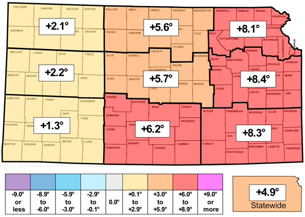
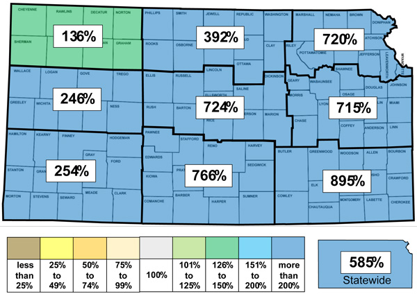
Figure 1. This week’s departure from normal temperature (°F, top) and percent of normal precipitation (bottom) by Kansas climate division. Source: MRCC.
Evapotranspiration and soil temperatures
The average evapotranspiration for grass across the state for the week was 0.41”. This is below the normal of 0.55” for the 7-day period. Divisional averages ranged from 0.33” in north central to 0.51” in southwest Kansas. The statewide average 2” soil temperature across the Kansas Mesonet fell 2.4° this week to 58.0°. This average is 6.4° above the normal of 51.6° for the 7-day period.
Drought update
In this week’s US Drought Monitor update, the past week's heavy rains led to a large area of 1-category improvements across the eastern half of the state (Figure 2). In all, 47% of the state was improved by one category, resulting in the complete removal of the D3 area as well as a reduction by more than half of the D2 areas in the state. Only 11% of the state is in D2 status. The statewide Drought Severity and Coverage Index (DSCI) fell 47 points and now stands at 164.
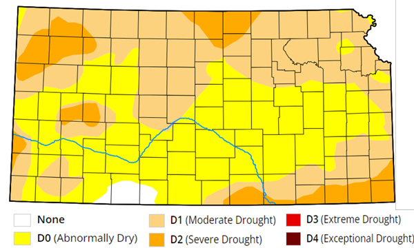
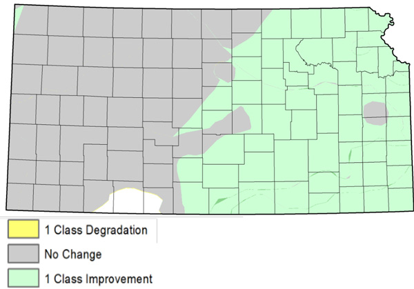
Figure 2. Current weekly drought status (top) and change in drought category over the past week (bottom). Source: UNL Drought Monitor.
Weather outlooks
The Weather Prediction Center’s 7-day precipitation forecast, valid for November 6-12, calls for another week with above-normal precipitation statewide (Figure 3). Unlike the past week, the highest amounts are expected in south central and southwest Kansas, where 2.5 to 4 inches of precipitation is possible. In the far northwest, temperatures could be cold enough for the precipitation to fall as snow. In eastern Kansas, lower amounts from 0.75 to 1.5 inches are expected. The bulk of the precipitation during the period is expected to fall from Friday into Saturday. These totals will add to the precipitation surplus for this month. The Midwest Regional Climate Center estimates an average of 1.83” of precipitation has fallen in Kansas so far in November. This amount currently ranks November 2024 as the 31st wettest November out of the last 130 years. Another inch of precipitation in the coming week would move this month up to the 11th wettest, with plenty of time later in November to potentially increase that total further. Average 7-day precipitation amounts across Kansas continue to decrease each week, and are down to 0.19” in western Kansas, 0.32” in central Kansas and 0.54” in eastern Kansas. Mild temperatures are expected to continue, with weekly temperatures expected to average from 3 to 7 degrees above normal, with eastern Kansas more above normal than in the west. The average daily high and low across Kansas for this period are 59° and 33°.
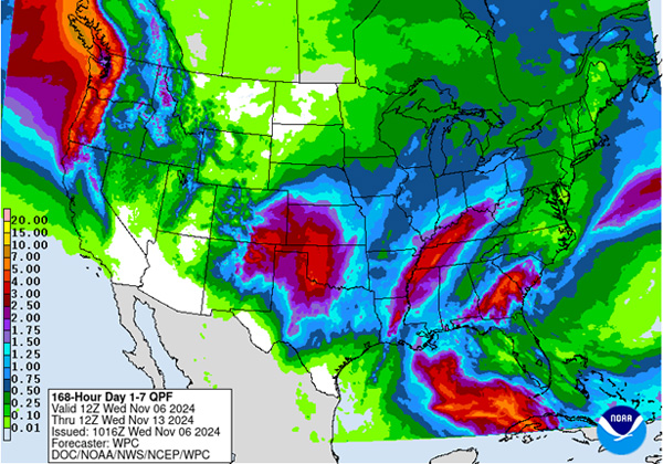
Figure 3. The National Weather Service Weather Prediction Center’s (NWS-WPC) 7-day precipitation forecast (Nov. 6 – 13, 2024).
The 8 to 14-day outlook (Figure 4), valid for the period November 13-19, has increasing probabilities of above-normal temperatures from west to east, with far western Kansas expected to have near-normal temperatures. The highest probability of above-normal temperatures is in far southeastern Kansas at 48%. There are slightly elevated chances of above-normal precipitation statewide, with probabilities ranging from 39% in extreme southwestern Kansas to 46% in the far northeast.
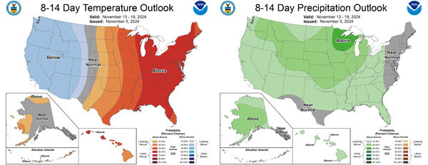
Figure 4.The National Weather Service Climate Prediction Center’s (NWS-CPC) 8 to 14-day temperature (left) and precipitation (right) outlooks.
Looking even further ahead, the Climate Prediction Center’s weeks 3 and 4 outlook (Figure 5), valid for the 14-day period from November 16th through the 29th, favors above-normal temperatures (55-60% probability) statewide. There are equal chances of above-normal and below-normal precipitation across most of the state, with slightly elevated chances of above-normal precipitation (50-60%) in the southeast.
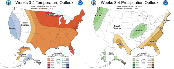
Figure 5.The Climate Prediction Center’s weeks 3 and 4 outlooks for temperature (left) and precipitation (right).
This article is a shortened version of the weekly Kansas Drought Update and Climate Report. If you would like to receive the full report delivered to your email each week, please send a request to Matt at msittel@ksu.edu. He will add you to his distribution list.
Matthew Sittel, Assistant State Climatologist
msittel@ksu.edu