Temperature summary
Above-normal temperatures were the rule across the state during the period. The average statewide temperature across the Kansas Mesonet was above normal all seven days, extending the string of above-normal days to 11 as of the 19th. Highs averaged in the 60s from the 14th through the 16th, with cooler 50s on the other four days. Only one morning, the 14th, had a sub-freezing average low (30°). Statewide daily average lows are now below freezing. Sub-freezing lows should be common this time of year, but this fall, fewer than normal have been recorded across the state. Goodland averages 23 days with lows at or below 32° by November 19th each fall but has had just 12 so far. Other locations well below normal in their freezing counts include Hill City (9; normal is 23), Dodge City (3; 14), Wichita (2; 14), and Topeka (1; 12). The 7-day average temperature was 48.8°, or 5.9° above normal (Figure 1). All nine divisions were above normal for the week; departures ranged from +2.9° in southwest to +8.6° in southeast Kansas. For November, Kansas is averaging 4.5° above normal. If the month finishes at the same departure, it would rank it as the 6th warmest of the past 130 Novembers.
Precipitation summary
The main precipitation event during the period began on the evening of the 17th. It continued into the 18th, the result of a strong low-pressure system that pulled moisture into the state as well as very mild air for mid-November. Many areas picked up over an inch of rain from this event, and at least 20 counties had one or more reports of rainfall of two inches or greater. The highest storm total was 3.00” in Kismet in Seward County. Dodge City measured 2.17” on the 18th, boosting their monthly total to 6.24”, which set a new record for the wettest November in 151 years of record-keeping. Wichita has also set their record wettest November with 6.99” of rainfall so far, including 1.58” that fell during the 7-day period. The only area that missed out on the event was far northwestern Kansas. Goodland recorded just a trace of precipitation, and all three CoCoRaHS observers in Cheyenne County measured zero for the 7-day period. Even in places where no rain fell, strong winds were observed in conjunction with the pressure gradient created by the deep low that moved through the state. The Little River Mesonet site in Rice County recorded a minimum sea-level pressure of 980.2 millibars or 28.95 inches. Pressures under 29 inches are very unusual in Kansas. Wind gusts of over 40 mph were recorded by at least three dozen Mesonet sites, with the highest gust of 64 mph at the Rock Springs tower in eastern Dickinson County. Not to be outdone, the Russell Airport clocked the highest reported gust at 66 mph.
The statewide average precipitation for the 7-day period was 1.48”, over four times the normal weekly amount of 0.31” (475%). All nine divisions in the state were above normal again this week (Figure 1). The three southern divisions were the wettest in the state, led by southeast (2.02”) Kansas. Southwest Kansas’ total of 1.63” was the highest percent of normal at a whopping 1458%. All divisions had at least triple their normal amount, even the driest division, northwest Kansas (0.57”). The recent precipitation further boosted the surpluses for the water year. Since October 1st, the average precipitation across Kansas is 5.94”, or 2.50” above normal. Divisional percents of normal range from 146% (northeast) to 231% (southwest). Since January 1st, the average statewide precipitation is 27.62”. This amount is 94% of normal or a departure of -1.65”. Three divisions are above normal for the year: southwest (114%), west central (107%), and east central (102%) Kansas. North central Kansas has the lowest percent of normal (88%) as well as the largest departure from normal (-3.31”). The preliminary estimate of the average November precipitation across Kansas is 5.18”, which is half an inch above the current record for wettest November (4.68”) set in 1909. All nine divisions currently rank in the top ten, with five divisions where the estimate exceeds the current record, most notably in southwest Kansas where the estimate of 5.06” is well over an inch ahead of the current record of 3.31”. The CoCoRaHS observer 4 miles north of Havana in Montgomery County has the highest total so far this month of 10.55”. The cooperative observers in Sedan (10.45”) and Fredonia (10.41”) are also above 10 inches for the month. The last time 10 inches or more was observed in Kansas in November was in 1998.
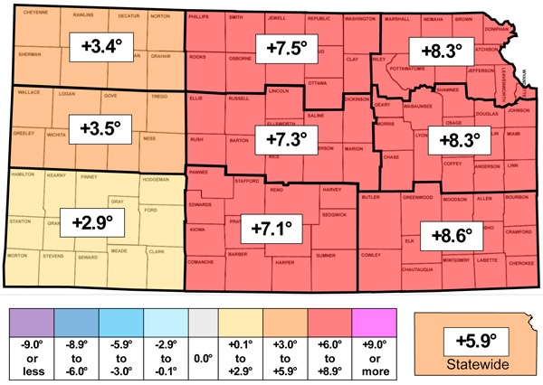
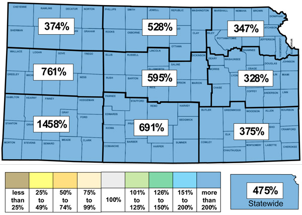
Figure 1. This week’s departure from normal temperature (°F, top) and percent of normal precipitation (bottom) by Kansas climate division. Source: MRCC.
Evapotranspiration and soil temperatures
The average evapotranspiration for grass across the state for the week was 0.47”. This is slightly below the normal of 0.50” for the 7-day period. Divisional averages ranged from 0.43” in east central to 0.53” in south central Kansas. The statewide average 2” soil temperature across the Kansas Mesonet fell 1.2° this week to 50.4°. This average is 4.9° above the normal of 45.5° for the 7-day period. Divisional averages ranged from 45° in northwest to 55° in southeast Kansas.
Drought update
In this week’s US Drought Monitor update, there were a few areas of one-category improvement, including parts of 29 counties (Figure 2). The largest areas were in north central as well as southeast Kansas. All remaining areas of D2 in the state were removed due to these changes. The last time all of Kansas was no worse than D1 was over three years ago, on July 27, 2021. The improvements boosted the percentage of drought-free area in the state to 30.4%, an increase of 3.6% from last week. The statewide Drought Severity and Coverage Index (DSCI) fell 9 points and now stands at 101.
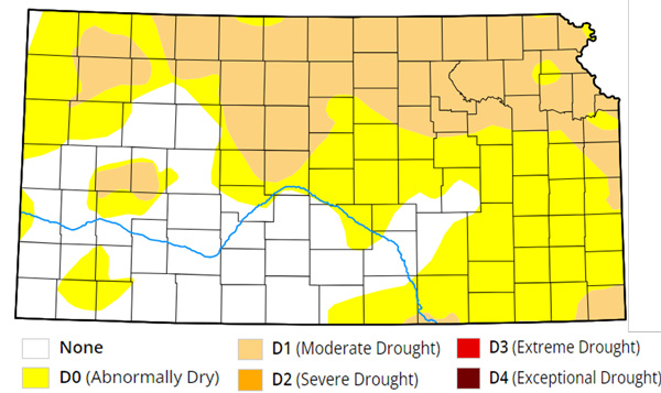
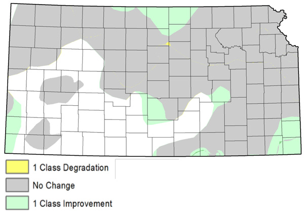
Figure 2. Current weekly drought status (top) and change in drought category over the past week (bottom). Source: UNL Drought Monitor.
Weather outlooks
The Weather Prediction Center’s 7-day precipitation forecast, valid for the period November 20th through the 26th, calls for a dry week for most areas (Figure 3). A few light amounts under one-tenth of an inch are possible in south central Kansas. Mild temperatures are expected to continue, with weekly temperatures expected to average from 2 to 6 degrees above normal, with the warmest temperatures expected this weekend. The average daily high and low across Kansas for this period are 52° and 28°. Average 7-day precipitation is 0.12” in western, 0.26” in central, and 0.44” in eastern Kansas.
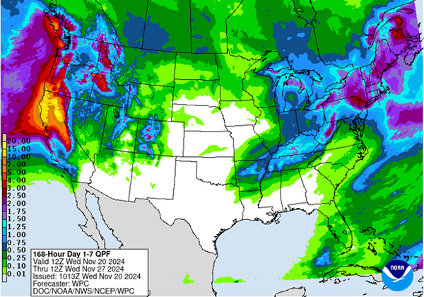
Figure 3. The National Weather Service Weather Prediction Center’s (NWS-WPC) 7-day precipitation forecast (Nov. 20 – 26, 2024).
The 8 to 14-day outlook (Figure 4), valid for November 27 through December 3, favors below-normal temperatures statewide, with probabilities increasing from southeast to northwest, ranging from 40% to 47%. Near normal precipitation is favored in eastern Kansas, with slightly elevated probabilities of above normal precipitation in the west, with the highest probability 36% in the far southwest.
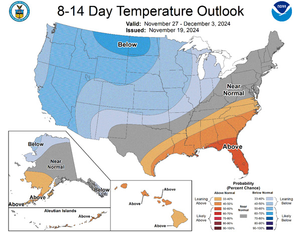
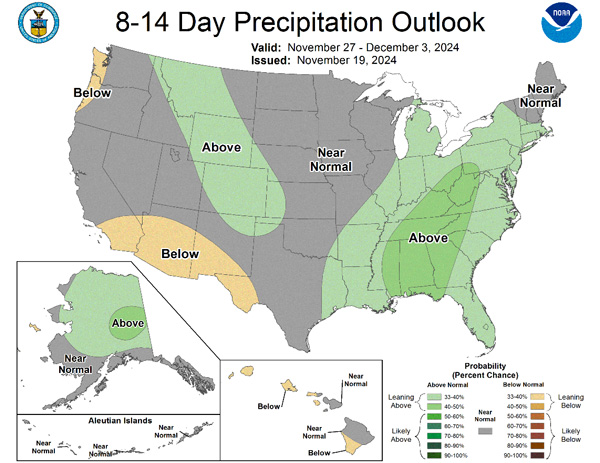
Figure 4.The National Weather Service Climate Prediction Center’s (NWS-CPC) 8 to 14-day temperature (top) and precipitation (bottom) outlooks.
Looking even further ahead, the Climate Prediction Center’s weeks 3 and 4 outlook (Figure 5), valid for the 14-day period from November 30th through December 13th, calls for equal chances of above and below normal temperatures for nearly the entire state; only far southeast Kansas has an above even chance for warmer than normal temperatures. Above-normal precipitation is favored (50-55% probability) in far eastern Kansas, with equal chances of above and below-normal precipitation across the remainder of the state.
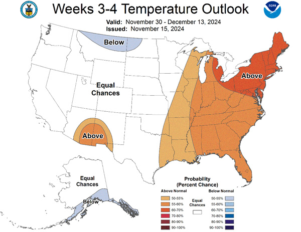
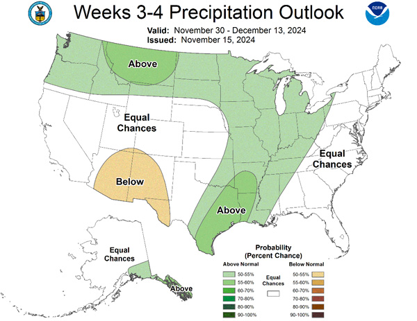
Figure 5.The Climate Prediction Center’s weeks 3 and 4 outlooks for temperature (left) and precipitation (right).
This article is a shortened version of the weekly Kansas Drought Update and Climate Report. If you would like to receive the full report delivered to your email each week, please send a request to Matt at msittel@ksu.edu. He will add you to his distribution list.
Matthew Sittel, Assistant State Climatologist
msittel@ksu.edu