Temperature and precipitation summary
The week featured two significant storms and two intrusions of Arctic Air, with a milder, dry respite in between. The first storm brought snow to the entire state. Amounts were generally less than forecast, as dry air ushered in by northeast winds reduced available moisture for snow production. Most of the state picked up between 1 and 4 inches. The highest reported total was 7” near Hunter in Mitchell County. Additional higher totals include 5.5” in Ness City, 5” in Marysville, and 4.5” in Atwood. Behind the departing low, frigid air overspread the state. Lows across the Kansas Mesonet on the 13th averaged a bitterly cold -7°, and the winter’s coldest temperature was recorded at the Scott City Mesonet tower that morning at -19.4°. There was a brief warmup on Valentine’s Day, especially in western Kansas, where highs reached well above normal in many locations, with 60s and even a few 70s noted. The cooperative observer and Mesonet site near Syracuse both recorded highs that afternoon of 74°. Colder air took hold once more on the 15th, and intensified through the end of the period, with a decrease in average temperatures each day from the 14th through the 18th. The average temperature in the state on the 18th was 0°, or 34° below normal, the most below normal day in four years since the bitter cold outbreak of mid-February 2021. The average high on the 18th was 5° or 42° below normal, and 21 Mesonet sites stayed below zero for the entire day. In addition to the cold, snow again fell across all of Kansas. Despite the very cold air in place, a few locations picked up heavy snow. Sterling had the highest total of 10.5”. Other high totals of note include 9.5” in Colby, 8.8” in Great Bend, 8” in McPherson, 7.8” in Iola, 7.1” in Hutchinson, and 7” in Newton. Similar to the first system, most snow totals in the state were in the 2 to 4-inch range. Bitter cold wind chills were the rule on the 18th, with most locations recording minimum wind chills from 15 to 30 below zero.
The 7-day average temperature for the state was 17.8°, or 16.3° below normal (Figure 1). Divisional departures ranged from -18.4° in northeast to -14.3° in southwest Kansas. The statewide average precipitation for the 7-day period was 0.28”, which is exactly normal (Figure 1). Six of the nine climate divisions finished the period with above-normal average precipitation, with northwest Kansas leading the way with both the highest amount (0.38”) and the highest percent of normal (262%). The driest division was southwest Kansas (0.15”) but the lowest percent of normal was in southeast Kansas (62%). For the year to date, the average precipitation across Kansas is 1.28”, or 0.16” below the normal amount of 1.44”. Five divisions are above normal for the year to date, with northeast Kansas being the wettest (2.50”). Southwest Kansas is the driest division (0.44”). Totals for the water year are still above normal statewide. The average precipitation since October 1st is 7.24”, or 111% of the normal of 6.52”, a departure of +0.72”. Divisional departures range from +0.31” in the northwest to +2.07” in south central Kansas. Percents of normal range from 105% in east central to 137% in southwest Kansas.
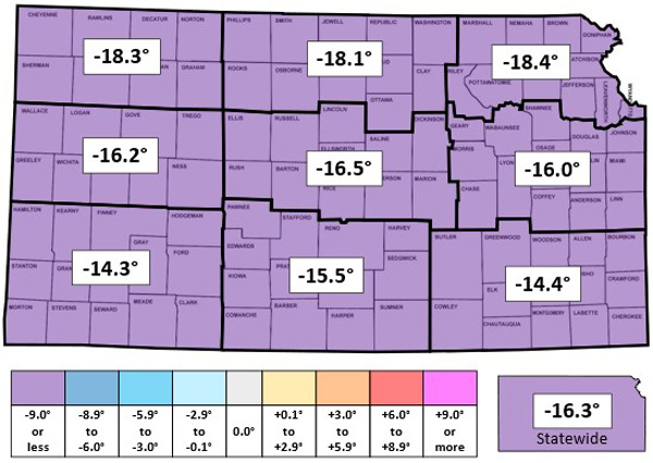
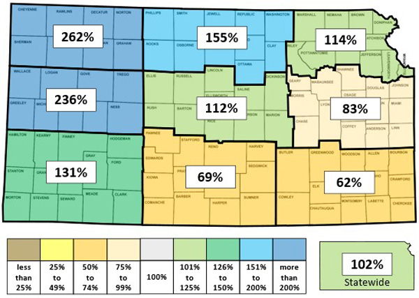
Figure 1. This week’s departure from normal temperature (°F, top) and percent of normal precipitation (bottom) by Kansas climate division (Source: MRCC).
The average evapotranspiration for grass across the state for the week was 0.25”. This is much below the normal amount (based on 12 years of Kansas Mesonet data from 2013 through 2024) of 0.46” for the 7-day period. Divisional averages ranged from 0.19” in north central, northeast and east central Kansas to 0.37” in southwest Kansas. The statewide average 2” soil temperature across the Kansas Mesonet cooled 2.6° since last week to 32.5°, which is 3.7° below the normal of 36.2° for the 7-day period. Divisional averages ranged from 30° in northwest to 36° in southeast Kansas.
Drought Update
In this week’s update of the US Drought Monitor (Figure 2), one-category improvements were made to parts of ten counties: Cheyenne and Sherman in northwest Kansas and eight counties in northeast Kansas. The changes in northeast Kansas include the communities of Seneca, Hiawatha, Troy, and Atchison. These adjustments added 2.3% to the percentage of drought-free areas in Kansas, which now stands at 33.9%. The statewide Drought Severity and Coverage Index (DSCI) fell 3 points to 88. The DSCI has been under 100 for 12 straight weeks, the longest run in over 3 years.
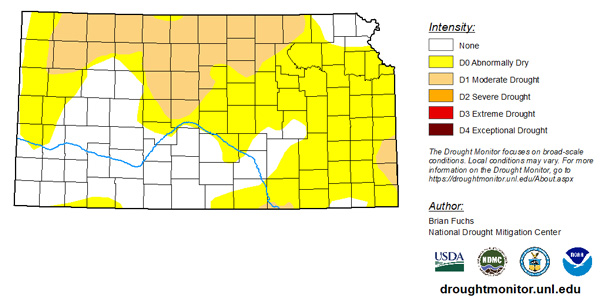
Figure 2. Drought monitor for Kansas as of February 18. 2025
Weather Outlooks
The Weather Prediction Center’s 7-day precipitation forecast, valid for the period February 19-26, calls for a dry week in most areas, with some very light precipitation possible in northwest Kansas (Figure 3). A warming trend is forecast to commence on Friday, with above-normal temperatures expected by early next week. However, with a very cold start to the period, the 7-day average should end up 5 to 10 degrees below normal. The month to date is running over 6 degrees below normal and will almost certainly be the second consecutive month with a below-normal average temperature. The average daily high and low across Kansas for this period are 49° and 24°. Average 7-day precipitation is 0.14” in western, 0.26” in central and 0.40” in eastern Kansas.
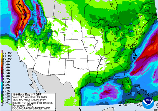
Figure 3. The National Weather Service Weather Prediction Center’s (NWS-WPC) 7-day precipitation forecast.
In the longer term, the 8 to 14-day outlook, valid for the period February 26 to March 4, favors above-normal temperatures in all areas (Figure 4). The probability of above-normal temperatures ranges from 42% in the far southeast to 57% in far northwest Kansas. Above-normal precipitation is slightly favored in all areas, with probabilities ranging from 36% to 41%, highest in the far southwest.
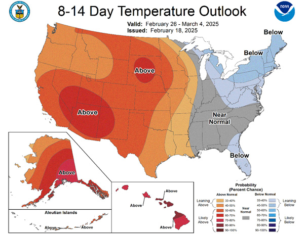
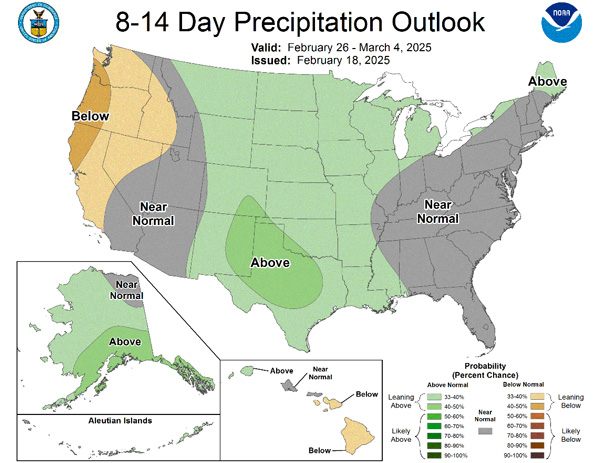
Figures 4. The National Weather Service Climate Prediction Center’s (NWS-CPC) 8 to 14-day temperature (top) and precipitation (bottom) outlooks.
Looking even further ahead, the Climate Prediction Center’s weeks 3 and 4 outlooks, valid for the 14-day period from March 1-14, favor above-normal temperatures, with probabilities from 50% to 60% (Figure 5). There are equal chances of above and below-normal precipitation statewide for the majority of the state, with slightly above-even chances of below-normal precipitation in southwest and south-central Kansas.
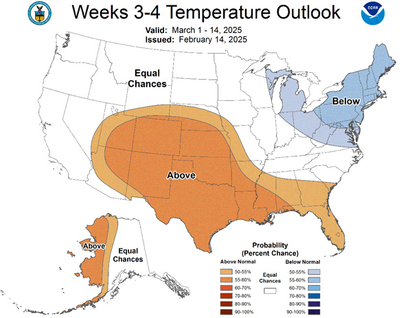
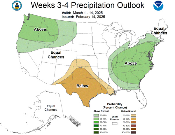
Figures 5. The Climate Prediction Center’s weeks 3 and 4 outlooks for temperature (top) and precipitation (bottom).
This article is a shortened version of the weekly Kansas Drought Update and Climate Report. If you would like to receive the full report delivered to your email each week, please send a request to Matt at msittel@ksu.edu. He will add you to his distribution list.
Matthew Sittel, Assistant State Climatologist
msittel@ksu.edu