Temperature summary
A 9-day run of below-normal temperatures ended on the first day of the period, December 4, when the average temperature across the Kansas Mesonet was nearly 10 degrees above normal. There was a 1-day return to below-normal conditions on the 5th before milder weather took hold again. There were 4 straight days of above-normal temperatures from the 6th through the 9th before another cooldown on the 10th brought slightly below-normal readings to end the period. The average high temperature was a chilly 36° on the 5th or 11 degrees below normal. But two days later, the average high on the 7th was 65°, over 18 degrees above normal. While the average high on the 8th was a bit cooler (58°), the week’s warmest temperature was recorded that afternoon in Wallace at a warm 74°. Goodland’s high of 68° on the 8th, while two degrees shy of a daily record, was 23 degrees above the normal for the date of 45°. Despite the rollercoaster ride of readings, average lows were below freezing on all 7 days and in the upper teens on both the 5th and the 6th. The 7-day average temperature was 37.5°, or 2.6° above normal (Figure 1). All nine divisions were above normal for the week; departures ranged from +0.4° in east central and southeast Kansas to +6.1° in northwest Kansas. The month to date is running 1.4 degrees above normal for December, based on Kansas Mesonet data for the first 10 days of the month. January through November 2024 currently ranks as the 4th warmest of the past 130 years, and there is the potential to move up on the final ranking for the full year of 2024 should warmer-than-normal conditions dominate the remainder of this month, which is currently forecast.
Precipitation summary
The only precipitation in the state during the period was in the form of isolated showers in southern and eastern Kansas on the afternoon and evening of the 8th. The highest precipitation total was 0.03” reported by the cooperative observers in Sedan and Pittsburg and a CoCoRaHS observer near Iola. The remainder of the state was dry for the entirety of the period. The statewide average precipitation for the 7-day period was 0.00”; the normal amount is 0.28”. Despite the recent dryness, precipitation remains above normal for the water year, which began on October 1. The average statewide total for the water year to date is 5.99”, or 1.69” above the normal of 4.30” (Figure 1). All nine divisions are above normal, with percents of normal ranging from 117% in the northeast to 196% in southwest Kansas. Departures from normal range from +0.87” in northeast to +3.11” in southeast Kansas. For the year, the statewide average precipitation is 27.66”, or 2.47” below normal. Two divisions are above normal for the year: southwest (112%), west central (105%). East central slipped to below normal this week (99%, -0.37”). North central has the lowest percent of normal (86%) as well as the largest departure from normal (-3.99”).
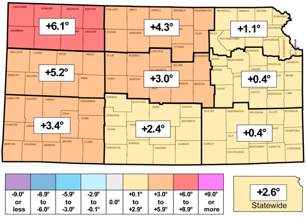
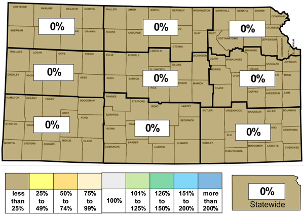
Figure 1. This week’s departure from normal temperature (°F, top) and percent of normal precipitation (bottom) by Kansas climate division. Source: MRCC.
Drought update
In this week’s US Drought Monitor map, the only change since last week was a 1-category improvement that includes parts of six counties in southwest and west central Kansas: Wichita, Scott, Lane, Ness, Kearny, and Finney. This change removed 2.1% of the D0 area in the state; 33.4% of Kansas is now free of any drought status (Figure 2). The statewide Drought Severity and Coverage Index (DSCI) fell 2 points and now stands at 96.
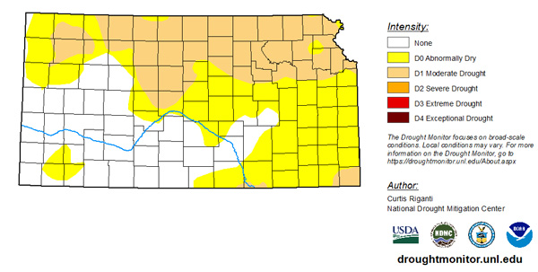
Figure 2. Current weekly drought status as of December 10, 2024. Source: UNL Drought Monitor.
Weather outlooks
The Weather Prediction Center’s 7-day precipitation forecast, valid for the period December 11th through the 17th, calls for precipitation in the eastern half of the state. Amounts are expected to be light in most areas, but a few areas may pick up 0.25” or more. A few of the higher forecast totals include 0.36” at Coffeyville, 0.35” at Lawrence, 0.34” at Parsons, and 0.28” at Olathe and Topeka. Most, if not all, of the precipitation should fall in liquid form, as a warming trend is predicted during the period. Average temperatures are expected to run from 2 to 10 above normal degrees during the period, with the highest departures expected in southern Kansas, where highs early next week could reach into the 60s. The average daily high and low across Kansas for this period are 44° and 22°. Average 7-day precipitation is 0.15” in western, 0.25” in central, and 0.38” in eastern Kansas.
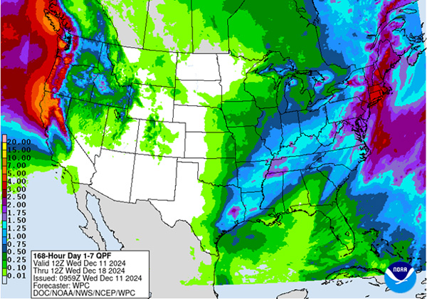
Figure 3. The National Weather Service Weather Prediction Center’s (NWS-WPC) 7-day precipitation forecast (Dec. 11 to Dec. 17, 2024).
In the longer term, the 8 to 14-day outlook (Figure 4), valid for December 18-24, strongly favors above-normal temperatures statewide, with probabilities ranging from 55% in the far southeast to 74% in the far northwest. Below-normal precipitation is slightly favored in most areas, with the highest probability of below-normal precipitation at 37% in far northwest Kansas. Near normal precipitation is favored south and east of a line from Olathe to Wellington, with a maximum probability of 36% in the far southeast. None of the precipitation probabilities are particularly noteworthy as they indicate low confidence in any one event occurring.
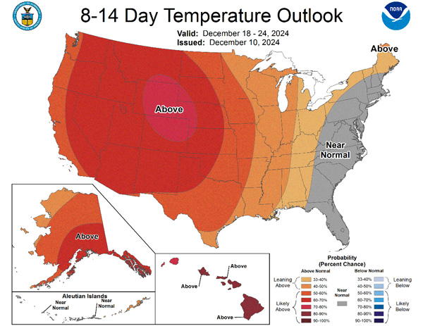
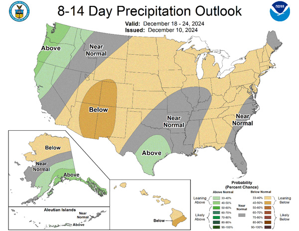
Figure 4.The National Weather Service Climate Prediction Center’s (NWS-CPC) 8 to 14-day temperature (top) and precipitation (bottom) outlooks.
Looking even further ahead, the Climate Prediction Center’s weeks 3 and 4 outlook, valid for the 14-day period from December 21st through January 3rd, including Christmas and New Year’s Day, calls for above-normal temperatures in western Kansas, with near-normal temperatures in east. The entire state has equal chances of above and below precipitation.
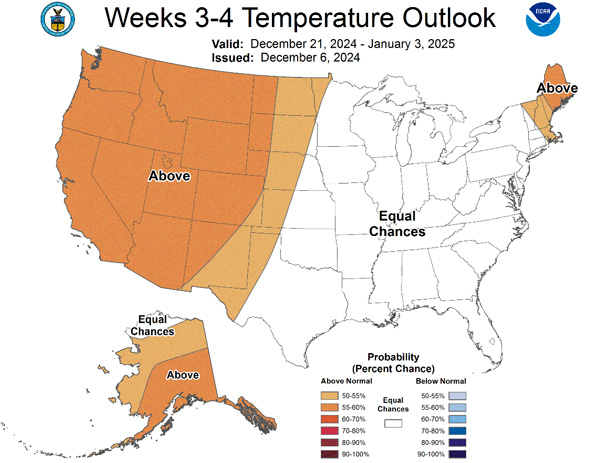
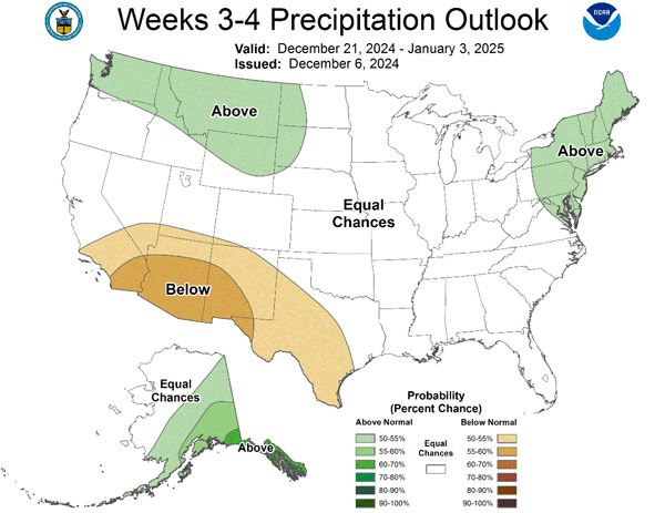
Figure 5.The Climate Prediction Center’s weeks 3 and 4 outlooks for temperature (left) and precipitation (right).
This article is a shortened version of the weekly Kansas Drought Update and Climate Report. If you would like to receive the full report delivered to your email each week, please send a request to Matt at msittel@ksu.edu. He will add you to his distribution list.
Matthew Sittel, Assistant State Climatologist
msittel@ksu.edu