Temperature summary
Temperatures at the start of the period were close to seasonal values, but a warming trend in the latter half of the period returned temperatures to above-normal readings. Average temperatures across the Kansas Mesonet were around 1 degree below normal for the 11th through the 13th but averaged a little over 9 degrees above normal from the 14th through the 17th. The warmest day was the 15th when the statewide average high was 62°, or 18 degrees above normal. Southwestern Kansas was the warmest area, with a couple of highs in the low 70s, including at Richfield in Morton County, where the co-operative observer recorded a high of 73°, the state’s warmest reading for the period. Low temperatures averaged below normal on all 7 days, with lows on the 12th and 13th averaging in the upper teens. The Mesonet site 6 miles northeast of Tribune in Greeley County fell to 9° on the morning of the 13th, which ties for the coldest temperature recorded in the state so far this late fall and early winter.
The 7-day average temperature was 36.8°, or 3.8° above normal (Figure 1). All nine divisions were above normal for the week; departures ranged from +2.4° in northwest to +7.1° in south central Kansas. The month to date is running 2.7 degrees above normal for December, based on Kansas Mesonet data for the first 17 days of the month. December is likely to be the fifth consecutive month with above-normal temperatures and the tenth month of 2024 with an average monthly temperature above normal. The year is currently projected to finish as the 3rd warmest of the last 130 years but could reach the second warmest if above-normal conditions linger through the rest of the month.
Precipitation summary
A few events brought precipitation to roughly the state's eastern half during the past 7 days. Late on the 10th, a band of light snow brought a dusting to parts of north central and northeast Kansas. The cooperative observer near Milford Lake in Geary County measured 0.5” of snow, the highest snow total for the week. A rain event occurred on the 14th, and out of all the areas that picked up rainfall, the highest totals were in north central Kansas. Concordia picked up 1.27", but just south of town, the co-op observer measured 1.51" for the event, the week’s highest total. Other notable totals include 0.76” at Beloit, 0.74” at the Washington County Mesonet site, and 0.42” at Russell. Far southeastern Kansas was grazed by isolated showers and thunderstorms late on the 15th into the pre-dawn hours of the 16th. The Tulsa radar's storm total map suggests southeastern Cherokee County received over an inch of rain near the Missouri and Oklahoma borders, but there are no reporters in this part of the county to verify that estimate. The CoCoRaHS observer in southeast Labette County reported 0.70" of rain from this event, while the northern parts of the county missed out entirely on moisture.
The statewide average precipitation for the 7-day period was 0.15”, or 54% of the normal amount of 0.28” (Figure 1). Two divisions were above normal: north central (0.40”) and northeast (0.34”) Kansas. Northwest and southwest Kansas averaged zero for the week, with 0.01” in west central and 0.02” in south central Kansas. Despite the continued prevalence of drier-than-normal conditions this month, precipitation totals remain above normal for the water year. The average statewide total since October 1st is 6.02”, or 1.44” above the normal of 4.58”. All nine divisions are above normal, with percent of normal ranging from 112% in both northeast and east central Kansas to 188% in southwest Kansas. Departures range from +0.63” in northeast to +2.68” in southeast Kansas. Around 87% of the state is above normal for the water year. For the year to date, the statewide average precipitation is 27.69”, or 2.71” below normal. Two divisions are above normal for the year: southwest (112%) and west central (105%). The north central and central divisions share honors for the lowest percent of normal (86%). Central Kansas has the largest departure for the year (-3.95”), slightly less than that for north central Kansas (-3.87”). Around 61 percent of the state’s most reliable observing sites (numbering roughly 400 sites, all with very few or no missing data for the year) are below normal.
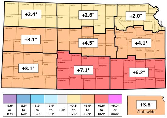
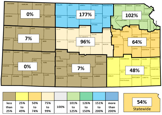
Figure 1. This week’s departure from normal temperature (°F, top) and percent of normal precipitation (bottom) by Kansas climate division. Source: MRCC.
Drought update
In this week’s US Drought Monitor map, one-category improvements were made to parts of nine counties. In the southwest, an area of D0 that covered parts of Grant, Haskell, Stevens, Seward, and Meade Counties was changed to drought-free status. In southeast Kansas, the improvements include portions of Montgomery, Labette, Cherokee, and Crawford Counties. This adjustment added new drought-free areas in Montgomery and Labette Counties. Overall, an additional 1.8% of the state was moved to drought-free status. A total of 35.2% of the state is currently drought-free (Figure 2). The statewide Drought Severity and Coverage Index (DSCI) fell 3 points and now stands at 93.
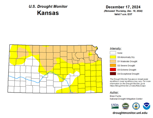
Figure 2. Current weekly drought status (top) and change in drought category over the past week (bottom). Source: UNL Drought Monitor.
Weather outlooks
The Weather Prediction Center’s 7-day precipitation forecast, valid for December 18th through the 24th, calls for light precipitation in east central and southeast Kansas (Figure 3). Totals are expected to be below normal in all areas. The highest forecast amount is in far southeastern Kansas, where one-quarter to one-half inch is possible. Average temperatures are expected to run from 5 to 13 above normal degrees during the period. Christmas Eve is expected to be the warmest day of the period, with highs in the 50s and lows near or slightly above freezing. The average daily high and low across Kansas for this period are 43° and 20°. Average 7-day precipitation is 0.15” in western, 0.25” in central, and 0.35” in eastern Kansas.
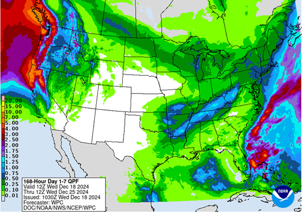
Figure 3. The National Weather Service Weather Prediction Center’s (NWS-WPC) 7-day precipitation forecast (Dec. 18 to Dec. 24, 2024).
In the longer term, the 8 to 14-day outlook (Figure 4), valid for the period December 25 to 31, including both Christmas Day as well as New Year’s Eve, strongly favors above-normal temperatures statewide, with probabilities ranging from 73% in the far southwest to 88% in the far northeast. Above-normal precipitation is slightly favored statewide, with probabilities ranging from 39% in the southeast to 41% in the northwest. At this time, a white Christmas looks unlikely for the state. For more about the chances of a white Christmas, check out the companion article in this eUpdate issue.
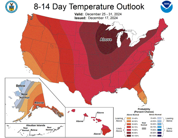
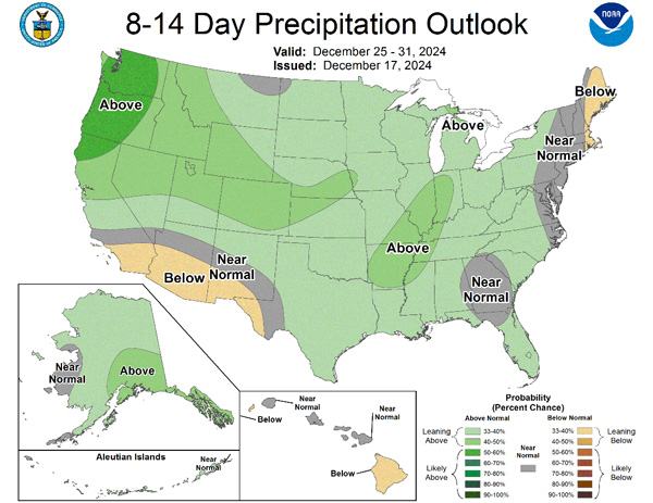
Figure 4.The National Weather Service Climate Prediction Center’s (NWS-CPC) 8 to 14-day temperature (top) and precipitation (bottom) outlooks.
Taking a look even further ahead into the new year, the Climate Prediction Center’s weeks 3 and 4 outlook, valid for the 14-day period from December 28 through January 10, calls for above-normal temperatures statewide, with probabilities ranging from 55 to 65 percent (Figure 5). The entire state also has equal chances of above and below precipitation.

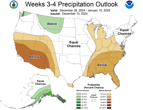
Figure 5.The Climate Prediction Center’s weeks 3 and 4 outlooks for temperature (left) and precipitation (right).
This article is a shortened version of the weekly Kansas Drought Update and Climate Report. If you would like to receive the full report delivered to your email each week, please send a request to Matt at msittel@ksu.edu. He will add you to his distribution list.
Matthew Sittel, Assistant State Climatologist
msittel@ksu.edu