This Kansas climate and drought update summarizes weather conditions across Kansas for April 22–28. Included are statewide and division updates on temperature, precipitation, soil conditions, evapotranspiration, and degree days, along with current drought status and short- and medium-term outlooks.
Temperature
The beginning of the period was well above normal. Both April 22 and 23 averaged around 12 degrees above normal, with most highs in the 70s and 80s. A few 90s were observed both days, mainly in the southwest on the 22nd and in south central Kansas on the 23rd. Richfield and Medicine Lodge recorded the week’s warmest temperature of 94°, the former on the 22nd and the latter the following afternoon. Lows were mostly in the 40s and 50s, but on the 28th, many locations dipped into the 30s, including at the Cheyenne County Mesonet site, which recorded a freeze at 31 degrees. The coldest readings of the week were on the 24th, when parts of western Kansas dropped into the upper 20s. Oakley, Colby, and the Sherman County Mesonet site all recorded lows of 28°, sharing the week’s coldest reading.
The statewide 7-day average temperature was 60.5°, or 4.2° above normal (Figure 1, top). All divisions were above normal, with departures ranging from +1.2° in the northwest to +6.1° in the southeast. As of April 29, the average April temperature is 59.2°, 6.9° above normal. Should April finish at that same value, it will rank as tied for the 6th warmest April on record. Only seven days in April have averaged below normal, while ten days this month have averaged at least 10 degrees above normal.
Precipitation
Multiple rounds of showers and thunderstorms, along with some severe weather, impacted the state during the period. The first event began on the afternoon of the 23rd. Storms fired up ahead of an advancing cold front in north central and central Kansas during the mid-afternoon. The storms moved eastward and northeastward across the state. Additional storms formed in south central Kansas, which also pushed east. Precipitation ended in all areas before sunrise. Observers in 16 different counties recorded over one inch of rain, with the highest total 1.81” in Cowley and Marion Counties. On the 25th, isolated storms formed across the state, prompting a few severe thunderstorm warnings. Metropolitan Wichita had thunderstorms early in the evening, and seven CoCoRaHS observers recorded between 2 and 3 inches of rain in Sedgwick County. The following afternoon, a bowing line of storms formed in central Kansas and tracked eastward into northeast and east central Kansas. Additional cells formed in south central and southeast Kansas during the evening. A second round of storms developed in west central Kansas during the mid-evening and tracked eastward into the overnight hours. Repeated rounds of storms moving across northeast and east central Kansas led to high rainfall totals and isolated reports of flooding. Totals for the 24-hour period ending at 7 AM on April 27 were highest along and near the I-70 corridor from Hays through Salina and Topeka to Kansas City, with more than two dozen counties receiving at least 2 inches of rain, based on amounts recorded by CoCoRaHS observers. The Topeka and Lawrence areas picked up at least 3 inches of rain, and a reporter southeast of Topeka measured 5.15” of rain. The same observer had 6.25” for the week, the state’s highest total. Unfortunately, in areas along the Colorado border and in southwest Kansas, precipitation was generally less than one-tenth of an inch.
The statewide average precipitation for the 7-day period was 1.15”, or 139% of the weekly normal of 0.82” (Figure 1, bottom). This average was heavily influenced by the two wettest divisions: east central (3.25”) and northeast (2.38”) Kansas. Southwest Kansas was the driest division, averaging only 0.01”. Precipitation for the first four weeks of the growing season has averaged 2.92” across the state, or 0.25” above normal. The three eastern Kansas divisions are all over 2 inches above normal, with east central both the wettest division (6.72”) and the most above normal (+3.26”). Northwest (0.37”) and southwest (0.38”) are the driest divisions.
For the year to date, the state's average precipitation is 5.48”, or 0.94” below normal. The three eastern divisions are all above normal while the three western divisions are all at less than half of normal. East central Kansas is by far the wettest division (12.89”; departure +4.67”), while northwest (1.18”; -2.77”) and southwest (1.21”; -2.50”) are driest. The three central divisions are all below normal, ranging from 65 to 96 percent. Statewide, 67% of the state is below normal for the year, with 37% of the state at least two inches below normal. Both of these numbers are five percent lower than last week, indicating some improvement in rainfall departures across the state.
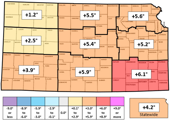
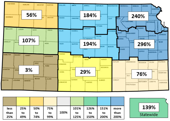
Figure 1. This week’s departure from normal temperature (°F, top) and percent of normal precipitation (bottom) by Kansas climate division. Maps generated by Matthew Sittle, K-State Extension.
Severe Weather
There were numerous reports of severe weather during the period. Nearly 30 tornado warnings were issued across eastern Kansas during the period, and 7 tornadoes were sighted. Three occurred on the 23rd: two in Morris County and one in Lyon County. Four additional tornadoes were spotted in southeast Kansas on the 26th: Two in Labette County, and one each in Montgomery and Wilson Counties. Over 140 severe thunderstorm warnings were issued, with 125 reports of severe hail at least 1 inch in diameter. The largest report was 4” in diameter in Marion County on the 23rd. There were at least 25 reports of severe winds of 58 mph or greater. The highest wind gust was 82 mph at the Cherokee County Mesonet site on the 26th.
Agricultural
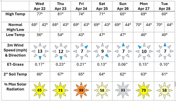
Daily statewide averages from the Kansas Mesonet for several variables are summarized in Table 1.
Soil temperatures continue to rise thanks to another week of above-normal temperatures. The average 2” soil temperature rose 1.1° this week to 63.7°, or 5.2° above normal. Divisional soil temperatures ranged from 61° in the northwest to 67° in the southwest. The only division in which soil temperatures fell below 50 degrees at any time during the week was in the northwest, but the percentage of time temperatures were that low was just one percent.
Weekly evapotranspiration (ET) for grass, estimated from Kansas Mesonet data, averaged 1.02”, or 0.06” below the 7-day normal of 1.08”. Southwest was the only division with above normal ET (+0.08”). Divisional averages ranged from 0.84” in east central to 1.30” in southwest Kansas. For the first four weeks of the growing season, total ET across Kansas has averaged 4.94”, or 0.45” above normal. Departures range from +0.00” in the southeast to +1.04” in the southwest.
The state averaged 66% of the maximum possible solar radiation this past week, below the climatological average of 72% of maximum for the seven-day period. April 26 was the lowest at 33% of maximum, while April 24 was the highest at 99% of maximum.
The average 2-meter wind speed for the period was 9.2 mph, above the weekly normal of 8.3 mph. April 22 was the windiest day with an average of 13.1 mph, one of two days with an average of at least 10 mph. The prevailing wind direction was from the north, recorded 25% of the week, based on 5-minute wind reports from the Kansas Mesonet.
Table 1. Average statewide daily climate data from the Kansas Mesonet for selected variables. ET-grass is the average daily evapotranspiration at each Mesonet site. The listed wind direction is the compass point with the highest count of daily observations. Solar radiation is the average percentage of maximum possible sunshine.
Degree Days Summary
The average was 81 growing degree days (GDD) for the week. This was 11 above the normal of 70. Divisional averages ranged from 57 to 99 across the state, with departures ranging from -4 in the northwest to +21 in the southeast. Since April 1, the state has averaged 356 GDD, or 108 above normal. All divisions are at least 70 above normal, with five divisions more than 120 GDD above normal.
Thanks to above normal temperatures, heating degree days (HDD) for the period were below normal again this week, averaging 46, or 23 below the normal of 69. Since July 1, the statewide average is 3880, or 1124 below the normal of 5004. The state averaged 6 cooling degree days (CDD) for the week, above the weekly normal of 4. The average count of CDD so far in 2026 is 61, or 48 above the normal amount of 13.
There was an average of 91 alfalfa weevil degree days across the state this week, bringing the average since January 1 to 992. Divisional averages ranged from 887 in north central to 1082 in the southeast. All divisions have now exceeded the pupa stage threshold of 814. There was an average of 84 western corn rootworm (WCR) degree days across Kansas, which brings the yearly average up to 323. Divisional averages for the year ranged from 218 in north central to 419 in south central Kansas. Egg hatch of rootworms typically begins at 380 WCR degree days, which has now been reached in southwest and south central Kansas. Southeast Kansas should exceed this threshold in the next few days.
Drought
In the April 28 update of the US Drought Monitor, parts of 31 counties were improved by one category (Figure 2, bottom). Areas in far southeastern Kansas where heavy rainfall was upgraded, as were portions of north central, central, northeast, and east central Kansas. There were multiple areas of one-category degradations across western Kansas. New areas of D3 were added in parts of 10 counties: Cheyenne, Rawlins, Decatur, and Norton in the northwest, and Hamilton, Stanton, Morton, Stevens, Meade, and Clark in the southwest. A new area of D2 was introduced in the Dodge City, Cimarron, and Sublette areas. The combination of adjustments resulted in a decrease in the percentage of Kansas in drought (D1 or worse) from 59.8 to 57.1 percent. However, the percentage of Kansas in D2 or worse increased from 32.6 to 37.7 percent this week. The amount of drought-free area in Kansas increased from 27.7% to 29.9% this week. The composite Drought Severity and Coverage Index (DSCI) increased 3 points to 169, indicating a slight worsening of overall conditions in the state. This is the highest DSCI since October 2024.
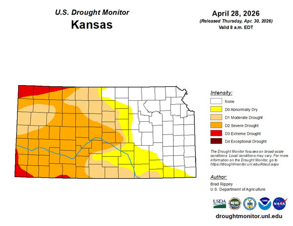
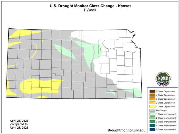
Figure 2. Current weekly drought status (top) and change in category over the past week (bottom) for Kansas (Source: U.S. Drought Monitor).
Looking ahead
The Weather Prediction Center’s 7-day precipitation forecast valid for the period April 29 through May 5, calls for below normal precipitation in nearly all areas, but parts of west central Kansas could pick up over half an inch of rainfall if a system passing to the west of the state produces moisture that can spread far enough east (Figure 3). The rest of the state is expected to receive less than one-quarter inch of rainfall. Average precipitation for the forecast period is 0.50” in western, 0.84” in central, and 1.22” in eastern Kansas. Temperatures are forecast to average within a couple of degrees of normal, with a slow warming trend expected during the period. Kansas’ average daily high and low for the 7-day period are 71° and 46°, respectively.
In the slightly longer term, the 8 to 14-day outlook for May 6 through 12 slightly favors below-normal temperatures for a second straight week (Figure 4, top). The probability of below-normal temperatures increases from west to east, ranging from 33% along the Colorado border to 44% along the Missouri border. Precipitation probabilities (Figure 4, bottom) for any one outcome amongst above, below, and near normal precipitation are no higher than 36% at any location in the state, suggestive of a low confidence forecast with nearly equally likely outcomes. Above-normal precipitation is slightly favored in the southeast, with near-normal precipitation most likely across the remainder of the state. Far northeastern Kansas has slightly elevated chances of below normal precipitation.
Looking even further ahead, the Climate Prediction Center’s weeks 3 and 4 outlook (Figure 5), issued on April 24 and valid for the 14-day period from May 9 through 22, favors below-normal temperatures across most of the state. The highest probabilities, ranging from 40 to 50 percent, lie across the eastern third of the state. Probabilities across the western two-thirds of the state range from 33 to 40 percent, with a small area across far southwestern Kansas having equal probabilities of above-, below-, and near-normal temperatures. Above normal precipitation is favored statewide, with most probabilities in the 33 to 40 percent range. Far southeastern Kansas has slightly higher probabilities, ranging from 40 to 50 percent.
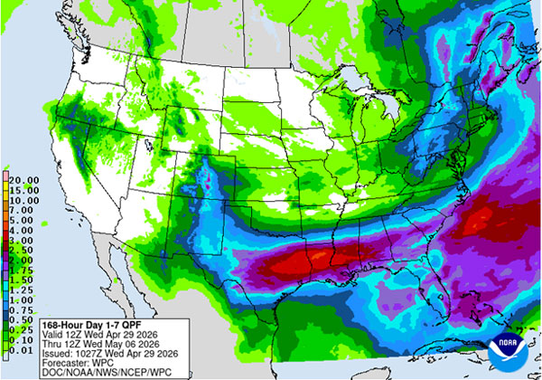
Figure 3. The National Weather Service Weather Prediction Center’s (NWS-WPC) 7-day precipitation forecast.
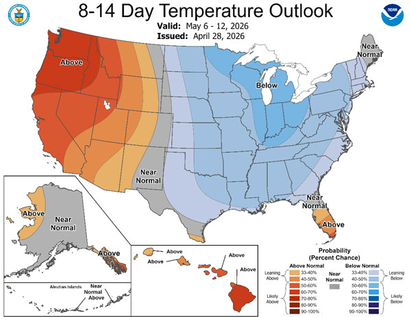
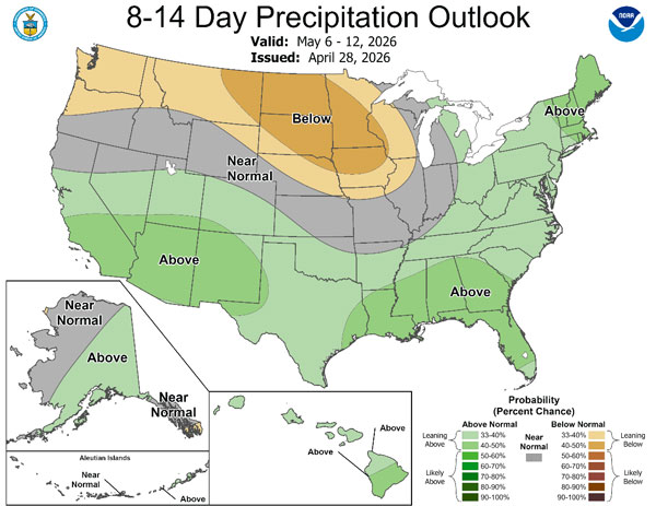
Figure 4. The National Weather Service Climate Prediction Center’s (NWS-CPC) 8 to 14-day temperature (top) and precipitation (bottom) outlooks.
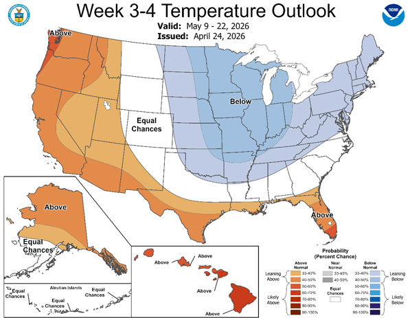
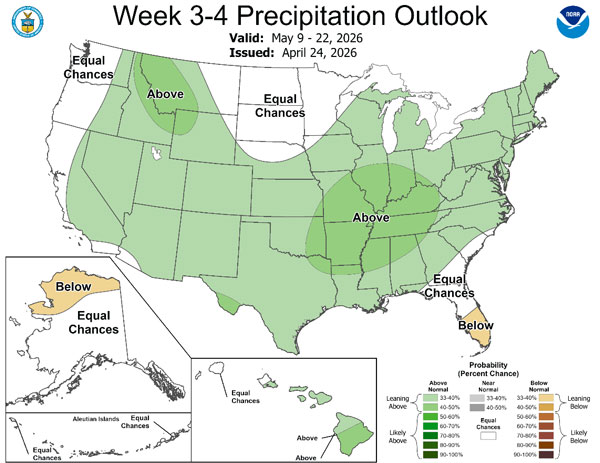
Figure 5. The Climate Prediction Center’s weeks 3 and 4 outlooks for temperature (top) and precipitation (bottom).
This article is an edited version of the weekly Kansas Drought Update and Climate Report; the full report includes additional tables and maps. If you would like to receive the full report delivered to your email each week, please send a request to Matt at msittel@ksu.edu to be added to the distribution list.
Matthew Sittel, Assistant State Climatologist
msittel@ksu.edu