The Kansas Ag-Climate Update is a joint effort between our climate and extension specialists. Every month the update includes a brief summary of that month, agronomic impacts, relevant maps and graphs, 1-month temperature and precipitation outlooks, monthly extremes, and notable highlights.
September 2021: Warm September for Corn Harvest
Statewide average temperature for the month was 73 oF, which is 4.3 oF warmer than normal. This ranks as the 10th warmest Septemper since 1895. Western Kansas had the warmest departure with an average of 5.0 oF warmer than normal. Precipitation was nearly normal (59th wettest month in 127 wet rankings). Moisture was distributed within the central portion of Kansas. Statewide average precipitation for the month was 2.85 inches, about 0.3 inches wetter than normal at the state scale.
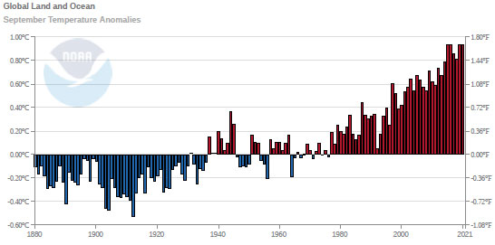
Global temperature continues to increase even with La Niña events in the equatorial Pacific churning up cooler-than-normal waters. Globally, this was the second warmest September on record (Figure 1). The most probable drought areas in October are three districts in Kansas (northwest, north central, and northeast), which could become worse as the one-month temperature outlook is above normal. However, the precipitation outlook seems to provide precipitation needed to end such light drought signals in northern Kansas.

Figure 1. Global temperature anomalies for September. Source: NOAA
View the entire September Ag-Climate Update, including the accompanying maps and graphics (not shown in this short article), at http://climate.k-state.edu/ag/updates/.