The Kansas Ag-Climate Update is a joint effort between our climate and extension specialists. Every month the update includes a brief summary of that month, agronomic impacts, relevant maps and graphs, 1-month temperature and precipitation outlooks, monthly extremes, and notable highlights.
July 2021: Statewide cool but unevenly dry
July was drier than normal. It ranked as the 54th driest July since 1895. As a percent of normal, the Northwest Division was the driest with 1.50 inches, 43 percent of normal. The Southeast was the wettest at 5.42 inches, 133 percent of normal. Unfortunately, uneven distribution was a problem, particularly in the southeast with heavy precipitation causing floods and followed by rapid drying (Figure 1).
Cooler-than-average temperatures slowed changes to the US Drought monitor. The statewide average for July was 1.4 degrees cooler than normal, ranking it as the 35th coolest July of record. There was one new daily record high maximum temperature and four record warm minimum temperatures. There were also 9 new record low maximums and 11 record low minimums. Despite the overall dryness, there were 65 new daily precipitation records, three of which were new daily records for July. Severe weather was limited in July with the report 0 tornadoes, 11 hail events, and 51 damaging wind events.
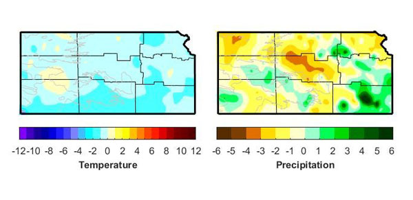
Figure 1. Departures from normal temperature (°F) and precipitation (inches) for July 2021 in Kansas. Maps by the Kansas Weather Data Library.
View the entire July Ag-Climate Update, including the accompanying maps and graphics (not shown in this short article), at http://climate.k-state.edu/ag/updates/.