The Kansas Ag-Climate Update is a joint effort between our climate and extension specialists. Every month the update includes a brief summary of that month, agronomic impacts, relevant maps and graphs, 1-month temperature and precipitation outlooks, monthly extremes, and notable highlights.
February 2022: Cooler in the south and less rainfall in the northeast
Statewide average temperature in Feburary dropped below the normal after a consective four-month warming from October to January. The statewide averaged temperature was -0.7oF cooler, which was stratifiedly distributed across the state’s latitutes. While the state was cooler than normal, the southern regions were slightly cooler compared to the rest of state (Figure 1). The temperature ranked as the 50th coldest and 79th warmest month during the past 128 years. However, considering the 4-month window for winter wheat, the average four-month (Nov. through Feb.) temperature was still the warmest since 2017.
Climatologically, Kansas January precipitation is about 1 inch. This month was slightly drier on average across the state (-0.5” departure from the normal). It ranked as the 26th driest month during the past 128 years. Similarly, considering the four-month accumulated precipitation for winter wheat, it was almost 2.5 inches drier than the four-month normal. This 4-month precipitation was the driest since 2018.
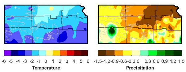
Figure 1. Departures from normal temperature (°F) and precipitation (inches) for February 2022.
View the entire February 2022 Ag-Climate Update, including the accompanying maps and graphics (not shown in this short summary), at http://climate.k-state.edu/ag/updates/.