The Kansas Ag-Climate Update is a joint effort between our climate and extension specialists. Every month the update includes a brief summary of that month, agronomic impacts, relevant maps and graphs, 1-month temperature and precipitation outlooks, monthly extremes, and notable highlights.
April 2022: Uniformly dry across the state
Statewide average temperature in April was close to the normal, with an average temperature of 53oF across the state (Fig. 1). April is one of two months (the other is October) that has a temperature that is close to the annual average temperature. April ranked as the 75th coldest and 54th warmest month during the past 128 years. However, considering the 6-month window for winter wheat growth, the average recent 6-month (November to April) temperature is ranked as the 16th warmest since 1895.
Climatologically, average April precipitation for Kansas is about 3 inches. In 2022, however, the state-wide average precipitation was only 1 inch, which was much drier than average. Most of this reduction occurred in the eastern portion of the state (1.8” below the normal) (Fig. 1). This ranked as the 3rd driest month of April during the past 128 years. Similarly, considering the 6-month accumulated precipitation for winter wheat growth, it was 3.5 inches less than the 6-month normal, which has the potential to decrease wheat grain yields.
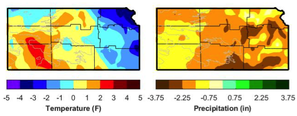
Figure 1. Departures from normal temperature (°F) and precipitation (inches) for April 2022.
View the entire April 2022 Ag-Climate Update, including the accompanying maps and graphics (not shown in this short summary), at http://climate.k-state.edu/ag/updates/
Tags: Climate